THE DARK CANYON WILDERNESS
- Canyon Walls and Open Parks
- Refuge for the Desert Bighorn
- Spectacular Prehistory
- The Utah Wilderness Coalition Proposal
Canyon Walls and Open Parks
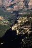
Like the Colorado River in Cataract Canyon and the San Juan River below Mexican Hat, Dark Canyon cuts into the 300-million-year-old Honaker Trail Formation, one of the oldest rock layers exposed in southern Utah. This formation's mixed limestones, shales, and sandstones and the overlying Halgaito Shale and Cedar Mesa Sandstone form the cliffs and talus slopes of Dark, Gypsum, and Bowdie canyons. The non-WSA lands around Beef Basin on the north have Cedar Mesa Sandstone canyon walls and pinnacles with canyon bottoms and open parks in the Halgaito Shale and unconsolidated sand. The rock layers of the Dark Canyon area have been lifted and tilted up slightly to the east and south by the Monument Upwarp which extends from Monument Valley to Canyonlands National Park. Relatively rapid erosion across this uplift is responsible for exposing the Paleozoic formations that are generally deeply buried across the rest of southern Utah. In upper Cross Canyon and Bull Valley, rock layers above the unstable Paradox Formation salts have slumped toward the Colorado River leaving grabens -- long parallel valleys -- which extend northward into Canyonlands National Park.Refuge for the Desert Bighorn
Riparian vegetation punctuated by cottonwoods grows in places along Dark, Gypsum, and Ruin canyons. A broad expanse of pinyon-juniper forest blankets the surrounding plateau. On the lower plateau in the western part of the area are enchanting "oriental gardens of cacti and other wildflowers set among deep, undisturbed cryptogam. The milkvetch Astragalus monumentalis and the daisy Erigeron kachinensis, both sensitive species, may occur in the area, according to the BLM. This area, like much of the southern part of Canyonlands, is an important refuge for the desert bighorn sheep. The BLM has identified most of the area (except Middle Point, Fable Valley, Beef Basin, and the Sweet Alice Hills) as crucial desert bighorn sheep habitat. Middle Point and Fable Valley are yearlong bighorn habitat, and the Beef Basin area is crucial deer winter range (BLM, 1985). The UDWR has identified a peregrine use area on the northeast edge of the area. Other species listed by the BLM include mountain lion, bobcat, ringtail cat, great horned owl, American kestrel, canyon wren, mountain bluebird, collared lizard, and Hopi rattlesnake.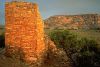
Spectacular Prehistory
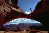
Dark Canyon was heavily used by the Anasazi, and its size and remoteness have helped preserve its rich archeological heritage. The BLM has identified 32 sites in its WSA, primarily cliff dwellings and granaries, and has concluded that "because of the inaccessibility of Dark Canyon, this [area] potentially contains numerous pristine cultural resources (BLM, 1986, p. 22). The BLM estimates that up to 2,658 sites could exist within the WSA, 1,773 of which could be eligible for the National Register. The non-WSA lands hold equally spectacular prehistoric sites. Beef Basin is a potential 35,000-acre National Register Eligible Archeological District: "The unique and accessible towers and other structures in Ruin Park are especially significant (BLM, 1985). The BLM goes on to say of the Butler Wash area just to the north and east of Beef Basin that "particular management consideration is needed to ensure continued protection if the area is not designated wilderness. (Emphasis added.) The Ruin Park towers and many other sites are in the Coalition-proposed Dark Canyon wilderness, but not in the BLM's recommended area. Continued isolation from vehicle access and large numbers of recreationists is the only hope for preserving these sites. Those who visit these ruins should refrain from touching them or walking in them.The BLM captured the allure of Dark Canyon in a hiking guide it published: "Lower Dark Canyon is set apart by an abundant supply of clear, flowing water and deep crystalline plunge pools. The hiker walks to the music of water tumbling over pour offs and rolling gently downstream. This reach of the canyon has attracted hikers ever since it was designated a Primitive Area in 1970. This administrative designation, one of the first in the nation, was a first step toward permanent congressional protection as a Wilderness Area. In 1986, the BLM recommended that the entire primitive area, now a 68,030-acre WSA, be designated as wilderness.
The agency's recommendation, however, excludes 62,000 acres of adjacent natural lands with important wilderness values. It fragmenting a single roadless area into many small subunits and assessed the naturalness and opportunities for solitude and primitive recreation of each separately. Of course, these values appear lower when one looks only at pieces of the whole. The BLM appears likely to propose forest chainings on much of the omitted wild land.
The Utah Wilderness Coalition Proposal
The Utah Wilderness Coalition supports wilderness designation for a 130,200-acre Dark Canyon wilderness to protect the entire area's extraordinary wildlife, cultural, and recreational values. Designating only the primitive area/WSA would risk losing the Anasazi sites and wildlife habitat of the plateau lands that surround the canyons. The proposed area includes the 3,700-acre Sheep Canyon unit on the west, which borders the popular Sundance Trail access to lower Dark Canyon.The lands we propose to add to the BLM's recommendation have few signs of human activity. A loop road in Beef Basin and side roads into Ruin Canyon and Beef Basin Wash are excluded from our proposal. A three-mile-long way on Middle Point is cherrystemmed to a stock facility; beyond that point the way is little used and is largely reclaimed. Our boundary follows the edge of existing forest chainings whereas the BLM drew its boundary at the canyon rims. Mineral potential is low within the area; the BLM concluded that its WSA has a "low potential for oil and gas, a "very low potential for locatable minerals, and that there is no coal, potash, or other leasable minerals (BLM, 1986, p. 19). Based on information in the BLM's land use planning documents (BLM, 1985), these conclusions also apply to the part of our proposal located outside the WSA.
Rodney Greeno
