THE GLEN CANYON WILDERNESS
"Awe was never Glen Canyon's province. That is for Grand Canyon. Glen Canyon was for delight."
So Wallace Stegner ("Glen Canyon Submersus," 1980) described the river journey only a few hundred boaters had known.
"Floating down the river one passed, every mile or two on right or left, the mouth of some side canyon, narrow, shadowed, releasing a secret stream into the taffy-colored, whirlpooled Colorado....Every such gulch used to be a little wonder, each with its multiplying branches, each as deep at the mouth as the parent canyon....Silt pockets out of reach of flood were gardens of fern and redbud; every talus and rockslide gave footing to cottonwood and willow and single-leafed ash; ponded places were solid with watercress; maidenhair hung from seepage cracks in the cliffs."
| There was a time when, in my search for essences, I concluded that the canyonland country had no heart. I was wrong. The canyonlands did have a heart, a living heart, and that heart was Glen Canyon and the golden, flowing Colorado River.
Edward Abbey
Beyond the Wall: Essays From the Outside (1984)
|
In March, 1963, the gates closed on the newly constructed Glen Canyon Dam, briefly interrupting a geologic process that had begun in the Jurassic Period. The windblown, crossbedded sands of the Navajo Sandstone, laid down in a desert climate more than 150 million years ago, had since been carved by the Colorado River into a hauntingly beautiful canyon. Now that canyon lies under the waters of Lake Powell, filling with sediment. The lake and its shoreline marinas have become one of most visited units of the National Park System, but a handful of pioneer river runners remember Glen Canyon of the Colorado as the very heart of earthly paradise.
The Canyon Returns
The reservoir and its accumulating sediments are a brief chapter of geologic evolution. Geologists predict that in a few centuries, Lake Powell will be a flat expanse of mud, sand, and boulders, with buried layers of human detritus. A few centuries more, and the dam will breach, beginning the cycle of erosion once again -- this time rapidly returning Glen Canyon to its former contour. Willow, cottonwood, and tamarisk will once again colonize the riverbanks; hanging gardens will grow on slickrock walls. Beaver, lizards, and bighorn sheep will return to their former haunts. If human beings are still seeking silence, solitude, and beauty, they too will return.
The Utah Wilderness Coalition's BLM wilderness proposal stands for the long view: the notion that we humans, being brief tenants on the planet, ought to leave a bit of the Earth as we found it. Our Glen Canyon wilderness proposal, in turn, stands for a corollary: that having altered most of the face of this lovely planet, we ought to return some small part of it to its former grace.
The Utah Wilderness Coalition Proposal
| Remember these things lost. The native wildlife; the chance to float quietly down a calm river, to let the current carry you past a thousand years of history, through a living canyon of incredible, haunting beauty.
David Brower
The Place No One Knew -- glen Canyon on the Colorado River (1963)
|
It is an audacious idea. Lake Powell, not Zion, Bryce, or Arches, is Utah's premier tourist attraction. Proposals to milk still more money from its sterile shores have been made; the State of Utah has proposed Federal land swaps to permit the construction of as many as six new marinas. The cool, echoing recesses of Glen Canyon are a nostalgic memory for only a few.
Someday, however, the Colorado River will resume its ancient work. Until that day, we propose to dedicate wilderness on each side of the river as a memorial to the lost canyon, and to its eventual, inevitable return.
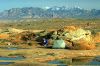
We include the Little Rockies in our proposed Glen Canyon wilderness because its canyons flow directly into the former course of the Colorado River. From high points in the unit one looks across Lake Powell to the remote, mysterious expanse of Mancos Mesa, the companion unit in the Glen Canyon area. Together these units make up 168,700 acres of BLM wild lands.
One day our descendants will be able to walk down Ticaboo Canyon, cross the muddy Colorado, and walk up Red Canyon below the imposing cliffs of Mancos Mesa. Along the way they will notice old banks of silt perched above the streambed. Perhaps they will see a plastic sixpack ring or an old bleach bottle poking out of the cutbank, and remember the brief moment in geologic time when humankind tried to remake a river.
Fred Swanson
MANCOS MESA UNIT
Highlights
The largest isolated slickrock mesa in southern Utah, Mancos Mesa's 180-square-mile table-top is bounded on every side by 1,000- to 1,500-foot-high cliffs. In a 1971 plan, the BLM recommended closing the entire mesa and Moki Canyon to mining and roadbuilding to protect a plant and animal community unusual for its large area without significant human disturbance. The BLM failed to withdraw the area from mineral entry, however, and from 1976 to 1979, extensive roadbuilding and uranium drilling (in violation of FLPMA's interim protection provisions) on the eastern third of the mesa left substantial scars. No economically significant mineral discoveries were made, and the roads were blocked to allow reclamation. The western half of the mesa is in the Glen Canyon NRA and is recommended by the Park Service for wilderness designation. The BLM initially recommended 46,120 acres for wilderness but left the entire southeastern portion and all of Moki Canyon unprotected. The final recommendation is expected to be 5,320 acres larger. The Coalition's 108,700-acre proposal would protect the entire mesa top, Moki Canyon, and about 40,000 wild acres south of Moki Canyon. The entire unit is yearlong bighorn sheep habitat (most of it is also crucial habitat).
Geology and landforms
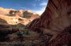
The mesa top is roughly triangular in shape with Moki Canyon on the south as the base, Red Canyon as the northeast side, and the drowned Colorado River gorge as the northwest side. Cedar Canyon and North Gulch drain into Lake Powell after cutting east to west across the width of the mesa. The entire unit is dominated by Navajo Sandstone with extensive areas of slickrock and dune sand. Cedar, Moki, and Steer Pasture canyons have deep inner canyons in the Wingate Sandstone. Windblown sand offers access into the canyons in places, notably at the "Sandslide" in Moki Canyon. There is water in several springs in the canyon bottoms.
Plant communities
The higher elevations on the east support pinyon and juniper, grading down through blackbrush, yucca, and Mormon tea to barest desert on the west. Riparian communities near the springs harbor cottonwood, oak, ash, willow, and watercress. Thanks to its inaccessibility, Mancos Mesa contains one of the few relict plant communities left in Utah. A 1970 BLM staff report described the mesa as a "near pristine example of the northern reaches of the upper Sonoran life zone." At that time, all but perhaps the northern tip of Mancos Mesa was in relict condition. (Grazing has since been expanded, however.) Valuable as a comparison area, the remaining relict community supports native perennial grasses, shrubs and some cacti. The report states that "Mancos has been isolated from the noticeable influences of man except limited grazing. Plant and animal communities are generally proceeding in a natural, unaltered environment, and few areas remain which offer pristine associations."

Wildlife
The BLM has designated the entire unit as yearlong bighorn habitat and the northern three-fourths as crucial desert bighorn sheep habitat (BLM, 1987b). This is an important native herd and supplies bighorns for transplant to other areas of Utah. Mule deer also live here, with bucks often of trophy size. Ringtail cat, mountain lion, bobcat, fox and coyote fill out the list of mammalian predators. The unit may also be peregrine falcon habitat. A number of reptiles inhabit the unit as well, including the chuckawalla lizard, unknown in most of Utah.
Archeology and history
Extensive archeological remains span 2,000 years of history and five different cultures. Lithic scatters, fireplaces, pithouses, kivas, and storage structures remain from the Basketmaker II and III, as well as the later Pueblo I, II, and III civilizations. A 1983 BLM memo states that Mancos Mesa "potentially contains numerous pristine cultural resources" and could contribute significant information on the livelihood of these peoples. In the lower reaches of Moki Canyon, the Park Service has documented dozens of Anasazi sites on NRA and BLM lands.
Recreation
Numerous remote, unnamed canyons await exploration, but gaining access to them is part of the challenge. Slickrock and sand dunes make for interesting hiking on the mesa top. Access is via a dirt road down Red Canyon or from Highway 263 between Clay Hills Divide and Halls Crossing.
BLM recommendation
The BLM recommended designation for 46,120 acres in 1986. Its final recommendation is expected to include 5,320 acres on the east end of the mesa that were left out of the draft recommendation. The agency improperly excluded 57,000 acres from study in its 1979 initial inventory decision as a result of mining exploration roads that had been constructed in violation of its wilderness inventory policy. A 1971 BLM management framework plan recommended that primitive qualities throughout the unit be protected "from mining and associated activities, roadbuilding, and mechanized travel of all forms."
Coalition proposal
We propose 108,700 acres of wilderness, with boundaries following natural features and including complete drainages wherever possible. Several vehicle tracks branch off the one passable road into the Burnt Spring area south of Moki Canyon, and the two that have noticeably impinged on the unit have been cherrystemmed out of the proposal. The vehicle track down the sand slide into Moki Canyon should be reclaimed (the BLM is considering proposals to do so at its WSA boundary on the north side of the canyon). The eastern boundary includes the land down to the road in Red Canyon, excluding areas of old mining impacts. These cliffs as well as the colorful escarpments of the Clay Hills and the Red House Cliffs in the southeast are beautiful, unusual, and completely natural and deserve protection. The mineral exploration of the late 1970s did not uncover any commercial deposits.
LITTLE ROCKIES UNIT
Highlights
While the peaks of the Little Rockies are geologically similar to the Henry Mountains, we include them in our proposed Glen Canyon wilderness because they are surrounded by slickrock canyons that -- like those in Mancos Mesa -- flow directly into the former course of the Colorado River in Glen Canyon. From high points in the unit one looks southeast across Lake Powell to the remote, mysterious expanse of Mancos Mesa, the companion unit in the Glen Canyon area. We propose 60,000 acres of wilderness to protect the rugged peaks of Mt. Holmes and Mt. Ellsworth, 50 miles of narrow, inviting canyons, and Navajo Sandstone slickrock. Access is easy from Utah Highway 276 which forms the unit's western boundary; the Glen Canyon National Recreation Area, through which the unit's canyons flow on their way to Lake Powell, forms the eastern boundary. The northern boundary is the high cliffs that line Highway 95 along North Wash before it reaches Lake Powell.
Geology and landforms
The Little Rockies were formed when an igneous intrusion pushed up flat-lying sedimentary rocks, forming a laccolithic dome similar to the nearby Henry Mountains. Erosion has since carved the laccolith into the prominent peaks of Mt. Ellsworth (8,295 feet) and Mt. Holmes (7,930 feet). Dikes and sills associated with the laccolith are exposed on the flanks of the peaks; light-colored diorite boulders eroded from the intrusive stock lie in the canyon bottoms. The Navajo Sandstone crops out around the peaks and is eroded into fins and pouroffs. The peaks were designated a National Natural Landmark in 1975 for their outstanding geologic features. One perennial stream, Trachyte Creek, drains the northeastern part of the unit, and a half-dozen small, ephemeral streams drain either into Trachyte Creek or directly into Lake Powell.
Plant communities
Since much of the unit is mountain slopes and slickrock, vegetation is sparse and consists primarily of desert shrubs such as blackbrush, Mormon tea, and shadscale, with juniper and pinyon pine scattered about. A few ponderosa pine cling to the north side of Mt. Ellsworth, where precipitation is higher and evaporation lower. Small areas of riparian vegetation are found along Trachyte Creek and in the canyon bottoms. The BLM (1986, p. 8) mentions one candidate threatened or endangered plant species, Hole-in-the-Rock prairie clover (Dalea epica), that grows in the southern part of the unit. The Maidenwater Sands hosts a natural plant community.
Wildlife
The endangered golden eagle has been sighted in the unit, according to the BLM, and a small band of desert bighorn was reintroduced to the area in 1985.
Archeology and history
Although the BLM has not finished an archeological resources inventory, it is likely that a variety of prehistoric occupation or hunting sites will be found, based on surveys in the adjacent Glen Canyon National Recreation Area.
Recreation
The unit's rough topography, broken by canyons and washes, is conducive to long day hikes and short backpack trips. Few people as yet explore this area. Trail and Swett canyons offer the easiest access to lower Trachyte Creek; Maidenwater and Woodruff canyons, narrower and more intimate, have interesting narrows and pouroffs to negotiate. Farther south, Fourmile and Ticaboo canyons offer long, remote canyons. A hike up Mt. Holmes or Mt. Ellsworth gives great views of most of the mountain ranges and canyon systems of south-central Utah. Hog Canyon, easily accessible from Highway 95 in North Wash, has a small spring at its head. All of these hikes are described in Kelsey (1987a); Hall (1982) describes a hike in Swett Canyon.
BLM recommendation
The BLM's 38,700-acre WSA, all of which it is recommending for wilderness, excludes wild lands on the north around Trachyte Point, the North Wash cliffs, and Maidenwater Canyon, and on the south near Ticaboo Mesa. The BLM held that mineral exploration roads and seismic lines put in before wilderness studies began marred natural qualities, but in a few places the WSA boundary was contracted far more than necessary. No significant mineral resources have been found, and the overall impact of exploration on the unit has been minor.
Coalition proposal
We propose a 60,000-acre Little Rockies wilderness unit, taking in 21,300 acres of wild lands that were improperly excluded from the WSA, including the scenic canyon of lower Maidenwater Creek, Hog Springs Canyon (excluding the trailhead facilities), and the south slopes of Mt. Ellsworth. The unit is virtually unblemished. A Park Service radio transmitter, which occupies a small site atop Mt. Ellsworth and is reached by helicopter, would be allowed to remain. A little-used four-wheel-drive road runs to an old mine on the northwest side of Mt. Ellsworth. A vehicle way on Trachyte Bench was built in 1979 during the wilderness review. Now unused and returning to a natural condition, most of the route is over sandy scrub terrain, and there are no permanent scars. Other signs of mineral exploration on Trachyte Bench and Ticaboo Mesa are excluded from our proposal, without making wholesale deletions of natural terrain as the BLM has done.
