THE HENRY MOUNTAINS WILDERNESS
- Frustrated Volcanoes
- A Cluster of Small Circles?
- Successful Appeals
- "Treating" the Range
- Strip Mining or Wilderness?
- MT. ELLEN-BLUE HILLS UNIT
- BULL MOUNTAIN UNIT
- RAGGED MOUNTAIN UNIT
- MT. PENNELL UNIT
- BULLFROG CREEK UNIT
- MT. HILLERS UNIT
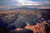 In the rectilinear landscape of southern Utah's canyon country, the Henry Mountains are a novelty -- huge purple domes looming strange and silent above the mesas and badlands that surround them. Between the high peaks of the Henrys and Capitol Reef National Park to the west, there are almost 350,000 acres of BLM-managed wild lands. It is one wilderness, spanning an exceptional variety of landforms and ecosystems. From the summit of 11,000-foot-high Mt. Pennell, the landscape plunges away to the west, dropping 6,400 feet, leveling out, then climbing 2,000 feet to the crest of the Waterpocket Fold. The panorama across this huge natural basin is one of the most dramatic and beautiful on the Colorado Plateau. It is also one of the most threatened.
The BLM would designate less than one-third of the region as wilderness, zoning the remainder for up to 40,000 acres of coal mining or deforestation. The Utah Wilderness Coalition proposal would protect all that remains of the Henry Mountains wilderness, from the crest of the mountain range to the summit of the Waterpocket Fold.
Frustrated Volcanoes
There is something mysterious about the Henry Mountains; something incongruous, something odd, something alien. Anyone who encounters them, hovering like spaceships over the lunar landscape of desert badlands surrounding them, gleaming with fresh snow or brooding in lavender tones under an umbrella of storm clouds, receives an immediate and lasting impression that they do not quite belong where they are. "They are by far the most striking features of the panorama," observed the geologist Clarence Dutton, "on account of the strong contrast they present to the scenery about them. Among innumerable flat crest-lines terminating in walls, they rise up grandly into peaks of Alpine form and grace like a modern cathedral among catacombs -- the gothic order of architecture contrasting with the elephantine."
| Directly east of us, beyond the domes of [the Waterpocket Fold], rise the Henry Mountains. They are barely 35 miles distant, and they seem to be near neighbors. Under a clear sky every detail is distinct and no finer view of them is possible. It seems as if a few hours of lively traveling would bring us there, but it is a two days' journey with the best of animals.
Clarence Dutton |
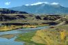
The Henrys are an ecological as well as a geological anomaly. "Projecting so far above the surface of the desert, they act as local condensers of moisture, and receive a generous supply of rain," noted Gilbert. "Springs abound upon their flanks, and their upper slopes are clothed with a luxuriant herbage and with groves of timber." While the Mancos Shale badlands at their feet are among the most biologically barren places on earth, the high peaks of the Henrys harbor forests of juniper, pinyon, ponderosa, r, spruce, aspen, and bristlecone pine. Such ecological diversity supports a wide variety of plant and animal species. Some 700 plant species exist in the BLM's Henry Mountains planning unit, including 14 species listed as threatened or endangered. The Utah State Department of Natural Resources has identified 62 "high interest species" of wildlife in the Henry Mountains region, including beaver, deer, cougar, bighorn sheep, and a herd of more than 300 buffalo -- the largest free-roaming, hunted buffalo herd in the nation. The mountain range, together with the benchlands and valleys on its flanks, provides 100,000 acres of critical summer and winter range for deer and buffalo.
A Cluster of Small Circles?
| At the time of [the Henry Mountain's] discovery by Professor Powell the mountains were in the center of the largest unexplored district in the territory of the United States -- a district which by its peculiar ruggedness had turned aside all previous travelers.
Grove Karl Gilbert |
In 1979, when the Bureau of Land Management began its inventory of Utah wild lands, the Henry Mountains region was a prime candidate for wilderness study. But by the fall of 1980, when the BLM completed its inventory, something had gone wrong. The BLM had arbitrarily omitted over 240,000 acres of wild lands from its wilderness inventory -- more than two-thirds of the Henry Mountains wilderness. Ignoring hundreds of thousands of acres of rugged mesa, canyon, and badlands terrain, the BLM had reduced a vast natural area to a cluster of small circles drawn around the summits of four high peaks in the range. All else had been dropped from the inventory.
In the two largest wilderness inventory units in the region -- Mt. Ellen and Mt. Pennell -- the BLM dropped more than 100,000 acres of land which the agency itself had acknowledged to be free of human impacts. Utah conservationists were astonished at the omissions. The BLM had dropped from the inventory some of the most beautiful, interesting, and important wild lands in the region, including some 50,000 acres surrounding Thompson, Wildcat, and South Caineville mesas and the eerie Blue Hills badlands, 15,000 acres of critical buffalo winter range on Swap Mesa, 37,000 acres of deep canyons along lower Bullfrog Creek, and 65,000 acres of Mancos Shale badlands south of Swap Mesa and Mt. Pennell.
Successful Appeals
In making the cuts, the BLM had repeatedly violated both the law and its own inventory policies, which clearly state that the agency must identify all lands with wilderness character as part of its inventory. In 1981, Utah conservationists appealed the BLM's inventory decisions, and in 1983, the Interior Department's Board of Land Appeals found the BLM in error on nearly 90 percent of the lands under appeal in the region. The IBLA directed the BLM to reconsider its decisions. The BLM reconsidered -- and once again dropped the same lands from the inventory. Once again Utah conservationists appealed, and once again the IBLA found the BLM decision in error. This time the IBLA simply ordered the BLM to add 65,000 acres to the Mt. Ellen and Mt. Pennell WSAs.But appeals could not force the BLM to acknowledge the outstanding character of the Henry Mountains wilderness. When the agency announced its draft wilderness recommendation in February, 1986, its meager 87,280-acre wilderness proposal omitted nearly 300,000 acres of wild lands surrounding the Henry Mountains -- roughly three-quarters of the Henry Mountain wilderness. The Ragged Mountain, Long Canyon, and Bullfrog Creek roadless areas should be open to development, the BLM decided. For the Mt. Pennell wilderness inventory unit, a 141,000-acre roadless area of stunning beauty and diversity, the BLM recommended no wilderness at all. The agency finally added a small part of Mt. Pennell, and increased the size of its Mt. Ellen recommendation, only following strong public protest.
Why has the BLM so tenaciously opposed wilderness designation in the Henrys? The answer lies buried in the agency's planning documents. At the time of the wilderness inventory, the nation was in the midst of an energy crisis, and the Carter Administration had identified coal as the fuel of the future. The mesas and badlands bordering the Henry Mountains on the west -- the lands repeatedly dropped from the BLM's wilderness inventory, and from its draft wilderness recommendations -- contain coal.
 By 1981, the BLM had completed a study which determined that over 100,000 acres within the Henry Mountains coal field should be opened to coal leasing, including 22,000 acres found suitable for strip mining. Had these lands been included within the Mt. Ellen and Mt. Pennell WSAs, they would have been closed to strip mining until the Congress could determine whether they should be protected as wilderness. Instead, all lands found suitable for coal development were summarily dropped from the two WSAs.
Ironically, the BLM was zoning for strip mining on a coal field that is of negligible value in comparison to the nation's vast coal reserves -- and to the scenic and recreational value of the wild lands which would be permanently scarred by strip mining. In total, the Henry Mountains coal field contains an estimated 230 million tons of recoverable coal -- but that coal may not be feasible to mine at all, given the aridity of the area and the distance to markets.
"Treating" the Range
Meanwhile, the BLM's desire to promote huge increases in the number of livestock on the range had begun to influence its wilderness recommendations for the Henry Mountains WSAs.By 1983, when the agency completed its Henry Mountains Grazing Environmental Impact Study (BLM, 1983b), it was clear that the range was seriously overgrazed. "Evidence of overgrazing still exists," stated the EIS. "Non-native, weedy annual plant species have become established; cheatgrass, Russian thistle, sunflowers, and various unpalatable mustards are common. There has been a gradual replacement of herbaceous species by woody species of lower forage value."
Throughout large portions of the Henry Mountains planning unit, overgrazing was so severe that it had caused serious soil erosion. The EIS identified more than 50,000 acres of rangelands in the planning unit as being in "severe" or "critical" erosion condition. A study of 46 streams in the planning unit revealed that over 50 percent of their riparian habitat was in poor condition due to overgrazing.
The problem is simple and clear: there are too many animals for the range. Since the passage of the Taylor Grazing Act in 1934, the BLM had made reductions in the number of livestock, yet the range remained overgrazed. Recent BLM trend studies had shown that range conditions are improving on less than one-third of the study plots -- and are declining on 20 percent. "The current numbers of big game (particularly bison) and allotted numbers of livestock presently overuse available forage in key...areas," concluded a 1988 BLM planning document. "Continuation of heavy use in these areas...will necessitate a reduction in the numbers of livestock and/or bison if ranges are to be protected."
While buffalo and deer have high visibility in BLM grazing studies, their numbers are negligible in comparison to livestock. In 1983, the BLM estimated that throughout the Henry Mountains planning unit, forage use by livestock was six times the use by wildlife. While the Henry Mountains buffalo herd numbers between 300 and 400 animals, and the Henry Mountains deer herd may have a population of several thousand, the 58 livestock permittees in the planning unit are running approximately 15,000 cattle and sheep on the range.
If there are too many animals for the available forage, the solution would seem as elementary as the problem: reduce the number of animals. But the BLM's management prescription for the Henry Mountains planning unit is precisely the opposite. In 1984, the agency announced that its long-term forage allocation for livestock throughout the planning unit would be an increase of 89 percent over 1983 levels of use. If implemented, the plan could nearly double the number of livestock on the range.
To support the increase in livestock, the BLM proposes to increase the amount of available forage by means of "vegetation treatment projects," in which blocks of pinyon-juniper forest would be destroyed by chaining or burning to create new artificial pastures for livestock. The Henry Mountains Grazing EIS (BLM, 1983b) proposed over 24,000 acres of such treatments, scattered across the forested flanks of the range. While the treatment projects were billed as habitat for wildlife, the BLM's own documents reveal that 82 percent of the additional forage would be consumed by livestock.
Where proposed range treatment projects lay within wilderness study areas, the BLM's solution was simple: lands identified for range treatment would not be recommended for wilderness. Thus in 1986 the agency recommended "no wilderness" for the entire 74,000-acre Mt. Pennell WSA in part because of a single proposed range treatment project -- variously depicted as 1,000 to 5,000 acres in size -- on the wild southwestern flank of the mountain. The BLM announced in 1990 that it would recommend 25,800 acres of its WSA. But in all, over 4,000 acres of proposed treatments lie within the Henry Mountains WSAs.
Wilderness designation will not eliminate livestock grazing in the Henry Mountains. The Wilderness Act allows grazing to continue at existing levels of use in designated wilderness areas. Instead, wilderness designation will help to ensure the long-term productivity of the range by preventing destructive developments such as strip mining and by placing upper limits on the number of animals on the range.
Strip Mining or Wilderness?
For the Henry Mountains wilderness, the choices for the future are clear. The BLM would allow at least 40,000 acres of strip mining and deforestation to scar the landscape between Capitol Reef National Park and the high peaks of the Henrys. By contrast, the Utah Wilderness Coalition proposal would protect long-term values, including wildlife habitat, scenic vistas, and the region's great potential for attracting tourism.The Coalition's 349,300-acre proposal would protect over 230,000 acres of superb natural landmarks which the BLM would zone for development. It would protect a complete ecological spectrum, ranging from the windswept alpine zone at the summit of Mt. Ellen, down through the forests of spruce, aspen, ponderosa, and pinyon pine, to the badlands surrounding the range. It would protect South Caineville Mesa, one of the largest relict plant areas in the state. It would protect the strange and beautiful Blue Hills badlands, and the lonely promontories of Wildcat, Thompson, Tarantula, and Swap mesas. It would protect tens of thousands of acres of critical winter habitat for buffalo and deer. Above all, it would protect the silence, mystery, and strange, compelling beauty of these visitors from another world.
MT. ELLEN-BLUE HILLS UNIT
Highlights
Two distinct landforms and vegetative areas characterize the unit: the virtually barren Blue Hills badlands and the 11,000-foot peaks of Mt. Ellen, which support dense pinyon-juniper, aspen, and spruce-fir forests. In juxtaposition, Mt. Ellen and the Blue Hills form a single roadless area -- one of the largest in Utah -- of spectacular ecologic, scenic, and recreational diversity. Mt. Ellen is a stunning backdrop for Capitol Reef National Park's slickrock domes and cliffs and for the nearby Escalante, San Rafael Swell, and Dirty Devil wilderness areas. The BLM's recommended wilderness unit excludes the spectacular mesas and badlands in the western part of the unit for the sake of insignificant coal deposits and uranium exploration. The Utah Wilderness Coalition's 116,900-acre proposal would protect sensitive watersheds, wildlife habitat, and relict plant communities.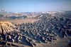
Geology and landforms
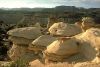
Mt. Ellen, at 11,615 feet, is the highest peak in the Henry Mountains. From the summit of its long, rolling ridge unfolds a panorama of dissected canyon country and mountain ranges. To the west of the peak are the mesas and badlands of the Blue Hills, carved into the Mancos Shale. These stark erosional features have been described as "ever so much badder than Badlands National Monument" (Hunt, 1980). Fossilized shark teeth are found here. The entire area has fascinated geologists ever since G.K. Gilbert's landmark 1875 monograph on the Henrys. Gilbert proposed a new theory of mountain uplift, the laccolith, now understood to have formed the La Sal and Abajo Mountains as well.Plant communities
Life zones ranging from the Upper Sonoran to Hudsonian are represented here. Aspen, subalpine r, Douglas r, and ponderosa pine dominate the slopes of Mt. Ellen; these are interspersed with windswept grasslands. Bristlecone pine grow on the highest slopes. A pinyon-juniper forest mantles the base of the mountain, grading into desert shrubs and eventually the utterly barren land of the Blue Hills. The BLM has designated South Caineville Mesa as an Area of Critical Environmental Concern (ACEC) because of its near-relict plant community. The mesa, which has not been grazed since 1950, supports abundant bunchgrasses (found in minimal densities on grazed lands) along with sagebrush, saltbush, and dwarf mountain mahogany. A 3,680-acre area, the Gilbert Badlands of Mancos Shale, harbors a unique relict plant community of mat saltbush.Wildlife
The slopes of Mt. Ellen provide critical habitat for the nation's only free-roaming, hunted buffalo herd. Mule deer, pronghorn antelope, and cougar also live here along with various small mammals and birds. The mesas offer fine promontories from which to watch raptors soar along a main hawk migration route. Virtually all species of raptors can be seen during the migration season including golden eagles and prairie falcons.Archeology and history
Although detailed surveys have not been done, the BLM (1986) notes 7 campsites and chipping sites around Mt. Ellen and 29 similar sites in the Blue Hills. An old stone herder's cabin on South Caineville Mesa, a lonely outpost, has been nominated to the National Register.Recreation
The summit of Mt. Ellen is a relatively easy jaunt along the ridge north from Bull Creek Pass; when snow blocks the road, ascents may be made from Lonesome Beaver Campground. Extended backpacking trips are possible via the Sweetwater Creek drainage or around the lower elevations of Mt. Ellen. The BLM notes that there are 60 miles of hiking routes in its WSA alone. Detailed hiking information is found in Kelsey (1986a; 1987a).BLM recommendation
The BLM recommended wilderness designation for Mt. Ellen itself, part of the Blue Hills, and connecting benchlands. Areas of equal wilderness values were split off and deleted. Some 7,300 acres were to be added to the recommendation in 1990 -- still a fraction of the omitted lands. The boundary proposed in 1986 skirts South Caineville Mesa with no difference in naturalness between the part deleted and that remaining in the WSA. The Blue Hills were also split through completely natural areas. These deletions closely follow the lines of mineral leases and claims. Most of the BLM's boundary follows section lines deleting magnificent portions of the Blue Hills from wilderness designation. The BLM proposal also deleted the important buffalo habitat found on the scenic Thompson and Wildcat Mesas. In violation of its wilderness study policy, the BLM has allowed bulldozing of a forest, construction of a reservoir, and construction of a new road. Instead of insisting on reclamation of these intrusions, the agency plans to drop the affected lands from its wilderness proposal. On the southeast corner of the WSA, the BLM illegally chained about 300 acres during the wilderness study. The agency recommended this portion for wilderness in 1986, claiming that it had been rehabilitated, but its final proposal is expected to omit the area.Coalition proposal
We propose wilderness designation for 116,900 acres, including areas excluded by the BLM (South Caineville Mesa, Thompson Mesa, Wildcat Mesa, Upper Sweetwater Creek, Oak Creek Ridge, and Cedar Creek). Dry drill holes and detailed geologic information substantiates the conclusion that there are no significant oil or gas conflicts within the area. Most of this unit is in a completely natural condition. The BLM lists 12.8 miles of ways, 2.5 miles of fence, and six livestock reservoirs within its WSA. Exxon cleared several acres and reconstructed nearly a mile of road to drill for oil and gas; there was no production, and the area was revegetated. The only impact on the 4,000-acre South Caineville Mesa is an historic stone shack near the mesa's southeastern ridge. The steep canyon, which serves as the only major access route to South Caineville Mesa, contains an eroded stock trail which has a minimal effect on naturalness. East of the mesa, our boundary follows a pipeline and access roads north to near the Fremont River. Wildcat Mesa is also substantially natural. In its intensive inventory documents, the BLM mentions no impacts on naturalness in the Upper Sweetwater Creek drainage or the deleted areas near Cedar Creek and Oak Creek Ridge.BULL MOUNTAIN UNIT
Highlights
The granite-cliffed dome of Bull Mountain (see Mt. Ellen map) is the northeast buttress of the Henry Mountains and a landmark for visitors to the surrounding canyons and deserts. Bull Mountain's striking landscape offers great vistas across the northern Colorado Plateau, excellent day hikes beginning from an established BLM campground on the west boundary, and crucial summer range for deer and bison. Bull Mountain is separated from the Mt. Ellen-Blue Hills unit on the west and the Ragged Mountain unit at two points on the south by only narrow unpaved roads. The Utah Wilderness Coalition proposes designation of 12,400 acres. The BLM recommends 11,800 acres, omitting scenic lands on the east side of the mountain.Geology and landforms
Like the other peaks in the Henry Mountains, Bull Mountain is the core of an igneous intrusion exposed by erosion of overlying sedimentary rocks. It is a bysmalith, in which the overlying rocks were lifted not by folding but by faulting, giving it steeper slopes than other peaks in the Henrys. Bull Mountain's golden cliffs and high ridges dominate the western half of the unit, while low-lying badlands and rims characterize the eastern half. Elevations vary from 5,000 feet in the northeast to 9,800 feet in the southwestern corner on Wickiup Ridge. Bull Creek drains along the western boundary and Granite Creek along the eastern side of the mountain. Granite Creek is the headwaters for Beaver Wash, a riparian area designated as an ACEC in the Dirty Devil proposed wilderness.Plant communities
Stands of aspen, ponderosa pine, and r grow at higher elevations, but pinyon-juniper and shrub-grass communities dominate the unit. Barren cliffs and badlands cover large areas, as well. The Cronquist wild-buckwheat (Eriogonum cronquistii), a sensitive species, occurs here.Wildlife
The BLM identified 4,550 acres of crucial deer summer range and 7,000 acres of crucial bison summer range in the WSA. The bison summer range is in the western side of the unit, and the deer summer range is in the southwestern part (BLM, 1983b, p. 53, p. 51). All non-WSA lands and the northeastern quarter of the WSA are yearlong antelope habitat (BLM, 1983b, p. 55).Recreation
Visitors to Bull Mountain enjoy excellent hiking, climbing, camping, geologic sightseeing, and wildlife viewing. The summit offers superlative views south and west to other peaks in the Henry Mountains, east to the Dirty Devil Canyons, and north to the Muddy Creek badlands and San Rafael Reef. The hike to the summit of Bull Mountain begins from the Lonesome Beaver campground (Kelsey, 1987a). The hike down Wickiup Ridge (a ridge with several peaks connecting Bull Mountain's summit with Mt. Ellen to the southwest) and Granite Ridge goes through a delightful aspen forest with distant views.BLM recommendation
The BLM recommends its 11,800-acre WSA for designation but fails to recommend several hundred acres that were improperly released from study during the wilderness inventory. In its 1980 intensive inventory decision, the BLM exaggerated the extent of impacts in the eastern portion of the unit. It excluded the claimed impacts and three state sections by drawing a straight-line boundary, thus violating inventory policy by not placing its WSA boundary at the edge of physical disturbance. The land excluded from the BLM's recommendation are almost entirely scenic, highly erosive Morrison badlands that are the foreground for views from Bull Mountain.Coalition proposal
We propose wilderness designation for the entire 12,400 acres of wild lands around Bull Mountain to protect outstanding scenic values, sensitive watersheds, and important wildlife values. These lands have insignificant mineral potential; the entire unit should be protected from ORV abuse, unwarranted mineral exploration, and destructive chainings in order to protect overriding natural values.RAGGED MOUNTAIN UNIT
Highlights
This unit contains the most visually striking example of the geologic forces that created the Henry Mountains. Rock layers pushed upward by molten rock form concentric circles of cliffs and canyons at the center of the unit. Ragged Mountain offers scenic vistas of this uplift as well as other peaks in the Henrys and across the surrounding deserts. While the BLM did not designate Ragged Mountain as a WSA, we propose a 23,300-acre unit to protect this central link in the Henry Mountain wilderness.Geology and landforms
Like Bull Mountain, Ragged Mountain itself is a bysmalith (an igneous intrusion with faulted sides). Just to the east, though, at the center of the unit is what may be the best expression in the Henry Mountains of a laccolith's doming effect on overlying sediments (see area overview). Here, The Block, a 7,646-foot peak, is surrounded by rings of Dakota, Morrison, Summerville, Entrada, Carmel, and Navajo formations. The harder layers form cliffs facing toward the Block. Canyons in the softer formations meet in Pyserts Hole east of the Block. Elevations vary almost 4,000 feet from 5,200 feet in North Wash on the eastern boundary to 9,113 feet at Ragged Mountain. Pennellen Pass, the low point on the ridge between Mt. Pennell and Mt. Ellen, lies on the western boundary of this unit.Plant communities
Pinyon and juniper forest predominates at higher elevations on the west; desert shrubs and grasses at lower slopes on the east.Wildlife
The BLM identified the western half of the unit as crucial summer range for bison and the south-central portion as crucial winter range for deer (BLM, 1983b, p. 51, 53).Recreation
Hikes through Pyserts Hole to Raggy Canyon and other drainages around The Block begin from the Crescent Creek road on the eastern side of the unit (this road joins Highway 95, 26 miles south of Hanksville just north of the junction of Highways 95 and 276). Ragged Mountain is most easily climbed from Garden Basin on the northwestern side of the mountain.BLM recommendation
The entire unit was released from wilderness review during the intensive inventory. The BLM claimed that only 15,000 acres retained their natural character and then dropped even that acreage by misapplying the outstanding opportunities criterion. In its November 1980 intensive inventory decision the agency found that opportunities for solitude "are less than outstanding on the majority of the unit due to poor vegetative screening." On the basis of this statement, the BLM violated inventory policy in two ways: (1) outstanding opportunities need only be present in part of the unit in order to qualify the entire unit for wilderness study and (2) vegetative screening is not the only factor in outstanding solitude; the unit's large size, blocked configuration, and rugged topography should also have been considered. Moreover, the vegetative screening provided by the unit's dense pinyon-juniper forest contributes to outstanding opportunities for solitude. The decision ignored the outstanding recreation values of the unit's spectacular geologic formations and scenic vistas.Coalition proposal
A 23,300-acre Ragged Mountain wilderness unit connecting the northern and southern peaks of the Henry Mountains should be designated to protect scenery, recreation, wildlife, and watershed values. The BLM has dropped its proposals for chainings within this unit, removing the only conflict with wilderness.MT. PENNELL UNIT
Highlights
The second highest peak in the Henry Mountains, Mt. Pennell crowns an area of great topographic and ecologic diversity. Averaging 12 miles east-west and 14 miles north-south with nearly 7,000 feet of relief, this is an awe-inspiring landscape of badlands, mesas, and mountains. From atop Mt. Pennell's summit at 11,371 feet, stunning vistas reveal how the badlands and mesas link the Henry Mountains to Capitol Reef National Park. None of this landscape was included in the BLM's 1986 recommendation, and a mere 25,800 acres was to be included in the agency's final recommendation. The Utah Wilderness Coalition proposal for designation of 141,200 acres as wilderness would safeguard it in its entirety.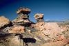
Geology and landforms
The expansive badlands in the southern half of the unit vary from relatively þat or rolling to extremely rugged. These badlands, with their abstract forms and stark shadows, offer outstanding sightseeing and photography. In the northwest quarter, Swap Mesa and Cave Flat are an intermediate step between the gray Mancos Shale badlands below and the light-colored high cliffs of the Mesa Verde Group surrounding Tarantula Mesa above. Mt. Pennell rises over all in the northeastern quarter, its igneous core exposed by the erosion of the overlying sediments. All but the northeastern and northwestern edges drain into Bullfrog Creek, which runs from north to south through the center of the unit. The BLM (1986, p. 14) rates 11 percent of the unit as in a critical erosion condition and 55 percent as moderate.Plant communities
The gentler badlands have shadscale, blackbrush, and grasses while the more rugged areas are barren. The mesas and the lower slopes of Mt. Pennell support pinyon-juniper forests; the higher slopes, oakbrush, aspen, and fir. The endangered Wright's fishhook cactus (Sclerocactus wrightiae) is found in the unit; Cronquist daisy (Eriogonum cronquistii) and Winkler cactus (Pediocactus winkleri), candidates for threatened or endangered listing, may be present. Five perennial streams and 11 springs support 38 acres of riparian vegetation (BLM, 1986, p. 14-15).Wildlife
The BLM (1986, p. 17) has identified at least 48,000 acres of the unit as "crucial-critical deer and/or bison range" and notes that mountain lions and coyotes are also present.Recreation
Mt. Pennell offers excellent opportunities for primitive and unconfined recreation, including rock climbing, backpacking, day hiking, nature study, photography, wildlife viewing, and even mountain skiing in winter. The five-mile-long route up Mt. Pennell, outlined in Kelsey's guide (1987a), climbs more than 3,500 feet. The diorite outcrop called The Horn is an excellent place to rock climb, offering smooth vertical faces as well as tamer hiking routes from the north and west (Kelsey, 1987a). The badlands offer excellent day hiking and photography opportunities.BLM recommendation
The BLM initially recommended none of its 74,300-acre WSA for wilderness designation and excluded an equal amount of wild land from the WSA. The final proposal is expected to be 25,800 acres. The non-WSA lands consist of about 33,000 acres in the Pennell Creek and Saleratus Wash badlands south of Mt. Pennell and about 40,000 acres on and north of Tarantula Mesa. The agency claimed (in its 1980 intensive inventory and 1983 reinventory decisions) that the Pennell Creek and Saleratus Wash badlands lacked outstanding solitude or primitive recreation. The "exploration disturbances" in the Saleratus Wash area are decades-old bulldozer tracks on highly erodible shales which are now largely unnoticeable. These extensive badlands are some of the most rugged terrain in all of Utah and provide solitude and beauty rivalling any wild place in America. The lands on and north of Tarantula Mesa were excluded for no stated reason in the BLM's 1980 intensive inventory decision. By excluding the chained portions of the mesa, our proposal retains the nearly pristine forest on the western and northern spurs of the mesa and the huge canyons cutting into its northern face -- Divide, Spring, Five, and Seven canyons.The BLM also gave no explicit rationale for recommending none of the WSA lands for wilderness designation. The 1,270 acres of strippable coal on Cave Flat are designated unsuitable for leasing by the BLM because of critical bison range and low oil and gas potential, and because hardrock mineral deposits "have been studied extensively since the 1890s and have remained subeconomical to develop due to their limited extent and quality" (BLM, 1986, p. 16-17). Twelve hundred acres are identified for potential chaining on the west side of Mt. Pennell, but this is hardly an excuse for not designating the other 73,000 acres of the WSA. The key to the BLM's reasoning lies not in its evaluation of resource conflicts, but in its evaluation of the wilderness resource itself. First, it claimed that 3,300 acres do not meet the naturalness criterion because of 12 miles of ways and 29.1 miles of roads (BLM, 1986, p. 19). These are, in fact, bulldozer tracks and vehicle ways which are largely unnoticeable in the context of the surrounding wild lands. Then the BLM claimed that only 17,800 acres have outstanding solitude and primitive recreation. Predictably, the outstanding area is found only on Mt. Pennell and not on Swap Mesa or the badlands south of Swap Mesa. Those areas were added to the WSA only after two conservationist appeals and a reversal by the IBLA. The BLM's unwillingness to recommend designation for this WSA is nothing less than an unwillingness to admit it was wrong. It also reflects the antipathy of the agency's politicized line officers to wilderness even in the absence of substantive conflicts.
Coalition proposal
At 141,200 acres, Mt. Pennell is the largest unit in our proposed Henry Mountains wilderness. This breathtaking landscape clearly deserves protection for its own sake and to complement the adjacent wild lands in Capitol Reef National Park. Our proposal includes important wildlife habitat, the unchained portions of Tarantula Mesa, and the magnificent escarpments surrounding Spring Canyon.BULLFROG CREEK UNIT
Highlights
Bullfrog Creek (see map of Long Canyon, Escalante area) is an intermittent stream that begins high on the western slopes of the Henry Mountains and flows south for 30 miles to the reservoir in Glen Canyon. Most of the first 18 miles lie in the badlands of the Mt. Pennell wilderness unit, the next 10 miles in an eye-popping thousand-foot-deep canyon in this unit, and the last 2 miles in the adjacent Glen Canyon National Recreation Area. The BLM released this unit from further wilderness consideration in its 1979 initial inventory. The Utah Wilderness Coalition proposal would preserve nearly the entire wild course of the creek, interrupted only by chainings on the headwaters, the unpaved Starr Springs-Eggnog road, and the Burr Trail.Geology and landforms
The canyons of Bullfrog Creek and its western tributary, Clay Canyon, are in the reddish-brown Entrada Sandstone and the chocolate muds of the Summerville Formation. The benches above the canyons, Middle Point and Clay Point, are in the colorful conglomerates, clays, and sandstones of the Morrison Formation, the light-colored Dakota Sandstone, and the lower layers of the gray Mancos Shale badlands (Hintze, n.d.). About 7,000 acres of this unit on Clay Point were identified as part of a 10,000-acre fossil plant locality by three Brigham Young University scientists (Welsh and others, 1980). They noted:The Salt Wash and Brushy Basin Members of the Morrison Formation are here exposed very well and contain an unusual concentration of fossil wood....It is principally to preserve some remnant of the large logs of this extensive Jurassic fossil conifer community that this area is proposed. Triassic fossil woods are well represented in the park system by Petrified Forest National Park but the equally, if not more, significant Jurassic woods, such as represented here, have not been placed under some protective umbrella....Primary concern here is for the rapid disappearance of the fossil wood from this Jurassic unit. Nowhere in the park system are extensive Jurassic fossil petrified forests preserved, yet this area, in which Morrison wood is abundant, is now being rapidly gleaned by rock hounds with extensive utilization of off-road vehicles.
Plant communities and wildlife
Sparse desert shrubs, mostly shadscale and blackbrush, cover most of the unit. Large areas are barren. Pinyon and juniper trees are found on the upper benches. The bench areas offer winter range for mule deer; the flats in the southeastern part of the unit are yearlong range for antelope (BLM, 1983b).Recreation
In addition to the outstanding opportunities for geologic sightseeing on Clay Point described above, the unit also offers outstanding hiking, backpacking, and photography in Bullfrog Creek canyon and Clay Canyon and on the rims of the canyons. The Burr Trail (which begins on Highway 276 six miles north of Bullfrog Marina) gives access to the western rim of the canyons. This road crosses Bullfrog Creek below the unit in Glen Canyon National Recreation Area. The Eggnog crossing of Bullfrog Creek on the north boundary is on the road that leads west and south from the BLM's Starr Spring Campground (which is reached from Highway 276 between mile posts 17 and 18) to the Burr Trail.BLM recommendation
The BLM did not designate Bullfrog Creek as a WSA, alleging that it had lost its natural character due to mineral exploration and off-road vehicle use.Coalition proposal
Our field work shows that only 3,000 acres of the BLM's 24,000-acre inventory unit (on the northern part of Clay Point and Hansen Canyon) are unnatural. Additional wild lands the BLM did not inventory bring the size of this unit to 36,900 acres. In the mid-1950s, a jeep track was put down Bullfrog Creek from Eggnog on the north. This has not been passable for more than 10 years, and there is little evidence of the vehicle way today. There are two 1/4-mile-long vehicle tracks across the benches to Clay Seep and Thompson Seep. These unmaintained and rarely used short tracks are also insignificant intrusions.MT. HILLERS UNIT
Highlights
The third highest peak in the Henry Mountains, Mt. Hillers is located between Mt. Pennell and the Little Rockies; as such it links the Henrys with the Glen Canyon proposed wilderness. The 18,600-acre unit offers fine scenery, hiking, and camping as well as important big game habitat. Mt. Hillers rises prominently to the west of Utah Highway 276 between Highway 95 and Bullfrog. A well-maintained gravel road leads from the highway to the BLM's Starr Spring Campground, a good place to begin a climb of the mountain. A dirt road circles west from Starr Spring to the north side of the mountain to two other starting places for climbing Mt. Hillers: Woodruff Stone Cabin and Cass Creek.Geology and landforms
The exposed igneous ridges of Mt. Hillers illustrate the geologic forces that formed this laccolithic mountain range. As in all of the Henrys, views from the top are outstanding. The Pink Cliffs, large slabs of Navajo Sandstone tilted up by the igneous intrusion on the south slope of the mountain, are highly scenic and geologically interesting.Plant communities
Douglas fir, ponderosa pine, and bristlecone pine grow on the steep slopes of the mountain.Some of the densest pinyon-juniper forest in the Henry Mountains is found on the bench areas of this unit.
