THE LABYRINTH CANYON WILDERNESS
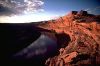
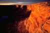
Twenty miles south of the Interstate 70 bridge, the Green River sinks gently into the land, winding for 50 miles through a series of "bowknot curves before entering Canyonlands National Park. This is Labyrinth Canyon, one of the last great wild rivers of the West, and an integral part of a 700,000-acre roadless region that includes Canyonlands.
Labyrinth Canyon's geological and archeological wonders are internationally recognized, and its recreational assets are extolled in a half-dozen guidebooks. The BLM's own planning documents emphasize the area's scenic and primitive character. Yet the BLM has recommended wilderness designation west of the river only, cutting the canyon in two and leaving more than half of the Labyrinth Canyon wilderness open to roadbuilding, mineral exploration, hydropower development, and indiscriminate off-road vehicle use.
By contrast, the Utah Wilderness Coalition's 171,700-acre Labyrinth Canyon wilderness proposal would protect the entire canyon system, while excluding all significant human impacts.
Wild River Corridor
"There is an exquisite charm in our ride today down this beautiful canyon. It gradually grows deeper with every mile of travel; the walls are symmetrically curved and grandly arched, of a beautiful color, and reflected in the quiet waters....We are all in fine spirits and feel very gay, and the badinage of the men is echoed from wall to wall."
Thus wrote John Wesley Powell, recalling his voyage of discovery through Labyrinth Canyon in 1869. For Powell, as for every river runner who has followed, the soaring sandstone walls, mirror-smooth water, and radiant gold light of Labyrinth Canyon have been irresistible.
Unique among Utah's wild rivers, the Green River through Labyrinth Canyon offers nearly 50 miles of smooth water unbroken by rapids or falls. It is a river runner's paradise. Guidebooks describe it in superlatives:
"...one of the finest river canyons I have floated in my twenty years of running rivers...calm and peaceful, a scenic wonder without parallel." (Verne Huser, Canyon Country Paddles)
"...the finest beginning canoe-camping trip in the state." (Gary Nichols, River Runner's Guide to Utah).
In 1974, an estimated 4,000 river runners boated the canyon, and according to the BLM, floatboating in Labyrinth has tripled since 1980.
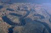
Labyrinth Canyon is the last vestige of what Glen Canyon had once been -- an elegant display of the power of a wild river cutting through the Navajo Sandstone, creating a textbook example of an entrenched meander. At Bowknot Bend, for instance, the Green River makes a nearly complete loop 7.5 miles long, doubling back to within just 1200 feet of itself. Throughout Labyrinth, the canyon walls are riddled with alcoves and caves. Stupendous natural bridges cling to the rim. A previously unreported double bridge was discovered in Labyrinth Canyon in 1986.
| About six miles below noon camp we go around a great bend to the right, five miles in length, and come back to a point within a quarter of a mile of where we started. Then we sweep around another great bend to the left, making a circuit of nine miles, and come back to a point within 600 feet of the beginning of the bend. In the two circuits we describe almost the figure 8. The men call it a `bowknot' of a river; so we name it Bowknot Bend.
John Wesley Powell
Canyons of the Colorado (1895)
|
Like its geology, the biological and cultural resources of the Labyrinth wilderness are rich and diverse. Deer graze among tamarisk and willow along the river. Beaver glide across lagoons at the mouths of sidecanyons. A dozen species of fish, including the endangered Colorado squawfish, bonytail chub, and humpback chub, live in the river. Coyote, bobcat, fox, and desert bighorn sheep roam the sidecanyons and benchlands. Hawks, vultures, and golden eagles share the updrafts with recently reintroduced peregrine falcons. Pronghorn antelope graze among the dunes and slickrock domes along the canyon's rims.
Deep in Horseshoe Canyon, a 35-mile-long sidecanyon, lies the Great Gallery, one of the finest museums of prehistoric rock art in the American Southwest. A 2,500-acre unit of Canyonlands National Park protects the site, but the rest of the canyon, including less well known pictograph panels, remains unprotected. Elsewhere in the Labyrinth Canyon system archeologists have discovered human artifacts nearly 9,000 years old. Among and below the human artifacts they found the dung of mammoth, bison, camel, sloth, and an extinct species of horse.
The BLM's Fractured Wilderness Proposal
One might expect that the BLM would seek full wilderness protection for such an outstanding area as Labyrinth Canyon. But the BLM's wilderness proposal is actually a blueprint for development.
| If the east side of Labyrinth Canyon is just as rugged and primitive as the west side, and if the old mining remnants do not detract from its natural character, why has the BLM eliminated the entire east half of the canyon from its wilderness recommendations?
|
In 1979, during the earliest stages of its wilderness inventory, the BLM drew a roadless area boundary right up the bottom of Labyrinth Canyon. Since the Green River in Labyrinth is navigable to motorboats, the BLM concluded that it was owned up to the high-water mark by the State of Utah. Thus the Labyrinth wilderness was bisected, in the BLM's view, by a corridor of non-federal land.
West of the river, the BLM identified two wilderness study areas (WSAs) spanning the length of Horseshoe Canyon, both of which it is now recommending for wilderness designation.
East of the river, the agency further fragmented the area into three separate units, and immediately dropped all three units from its wilderness review.
Ironically, the BLM had earlier earmarked more than 14,000 acres in Tenmile and Hellroaring canyons -- both east of the river -- as potential primitive areas. "...Hellroaring and Tenmile are both still in a pristine status, one staff report concluded. "This, along with their natural ruggedness and beauty warrants consideration of the primitive area designation. The BLM created a "scenic river corridor in 1977 to prevent oil and gas exploration within Labyrinth Canyon, and in 1979 it proposed the Green River in Labyrinth as a candidate for Wild and Scenic River designation.
The BLM's subsequent rationale for eliminating more than 30,000 acres of wild lands from its wilderness recommendation is far from convincing. "Opportunities for solitude and primitive recreation are probably present, explains the wilderness inventory evaluation sheet for the roadless area surrounding Tenmile Canyon, "however, the topography is typical of...the general area. Because the topography is typical, opportunities...are seen as average and not outstanding. Earlier BLM staff reports had reached precisely the opposite conclusion: "While there are other canyons of a similar nature in the general area, Tenmile is unique in that it still remains in an undisturbed condition.
 Elsewhere along the east bank, the BLM claimed that the canyon had lost its naturalness as a result of uranium mining. During the past 40 years developers have riddled some of the benchlands near Labyrinth with vehicle ways and seismic lines, searching for oil, uranium, and potash deposits which they never seem to find. And during the 1950s, uranium prospectors pushed a jeep trail to the mouth of Spring Canyon and nine miles upstream along the east side of Labyrinth Canyon to a mining camp at the mouth of Hey Joe Canyon.
These mining relics have now been abandoned for a quarter of a century, and while some of them are still visible, they are insignificant in comparison to the vast canyon system surrounding them. In high water, portions of the trail to Hey Joe Canyon have been inundated by the Green River, and in places it has been covered by rock slides. It has never been maintained, and its eventual obliteration is inevitable.
Moreover, the BLM has included identical mining impacts within its proposed Horseshoe Canyon wilderness directly across the river, stating that they do not affect the outstanding wilderness character of the canyon. "Natural processes are slowly reclaiming the road cuts, concludes the DEIS. "The imprints are localized and do not detract from the WSA's natural character.
Held Open For Mining Exploration
If the east side of Labyrinth Canyon is just as rugged and primitive as the west side, and if the old mining remnants do not detract from its natural character, why has the BLM eliminated the entire east half of the canyon from its wilderness recommendations?
Behind the official rationale about "less than outstanding wilderness values, there lies a more plausible explanation: during the wilderness inventory of 1979, BLM lands on the eastern perimeter of Labyrinth Canyon were intensively explored for potash and uranium. In 1977, the BLM had approved a proposal by Buttes Oil and Gas to develop a giant potash solution mining plant just east of the canyon. Wilderness studies would have restricted exploration for uranium and potash.
But even as Buttes began drilling its first exploratory wells in 1978, the market for domestic potash was collapsing. By 1986, Moab's nearby Texasgulf potash plant had laid off 375 of its 400 workers, and Buttes had mothballed the project near Labyrinth Canyon. Meanwhile, the price of uranium fell through the floor, forcing the closure of uranium mills throughout the southwest -- including the Atlas uranium mill in Moab.
The BLM's analysis of the mineral potential of its Horseshoe Canyon WSAs demonstrates that the economic value of development in Labyrinth Canyon is negligible; years of exploration have yet to discover an economically developable resource. Even by the agency's own estimates, any deposits would be small. In the Horseshoe Canyon (South) WSA, "the likelihood for production of oil from tar sand is thought to be minimal; the WSA "has low potential for...oil and gas; there are "no known commercial deposits of locatable minerals, and "no known deposits of leasable minerals. As in the Horseshoe Canyon (North) WSA, oil and gas exploration has been uniformly unsuccessful, and "the extremely rugged surface in the majority of the WSA could make drilling uneconomical. As for potash: "the likelihood of this area being a target for exploration and possible development is very remote.... The WSA is "considered geologically unfavorable for coal; manganese deposits "are chiefly small and low grade, and copper deposits "would probably be small. In 25 years of uranium exploration and mining, three historic uranium mines in the WSA have produced "less than 100 tons of uranium ore, and "all surface deposits probably have been discovered.
Of all the development proposals for Labyrinth Canyon, perhaps the most questionable is one for a hydroelectric dam. Studies have identified two potential damsites which would flood Labyrinth Canyon, destroying yet another magnificent wild river to generate only 165 megawatts of power.
The Utah Wilderness Coalition Proposal
In Labyrinth Canyon, the choices for the future are clear. The BLM recommendation would leave the entire river corridor and the east half of the canyon open for development, as well as much of the west half. Future mineral exploration could scar Labyrinth and its magnificent sidecanyons -- and still produce little or nothing of significance.
The Utah Wilderness Coalition seeks to preserve the wilderness character of the entire canyon system. We recommend wilderness designation for 171,700 acres in two units, Upper Horseshoe Canyon and Labyrinth Canyon. These units incorporate the following key areas omitted from the BLM's recommendation: Three Canyon, Tenmile Canyon, Hellroaring Canyon, Spring Canyon, and The Spur.
Ray Wheeler
| At 2:05 p.m. we entered Labyrinth Canyon. This masterpiece of nature is well named. The river twists and turns sinuously. Red sandstone walls rising two hundred to four hundred feet surrounded us and hemmed in the river -- what a quick change from open country into a canyon -- but the water remained quiet and smooth.
Barry Goldwater
Delightful Journey Down the Green and Colorado Rivers (1940)
|
LABYRINTH CANYON UNIT
Highlights
Labyrinth Canyon and its spectacular sidecanyons, arrayed along 46 miles of the Green River from Trin-Alcove Bend to Canyonlands National Park, dominate this 120,000-acre unit of the Labyrinth wilderness. Preserving this northernmost component of the wild Canyonlands region would ensure that the magnificent 120-mile wilderness float trip from below the town of Green River to the conþuence with the Colorado River would remain peaceful and uncluttered by the artifacts of civilization. The unit joins the Upper Horseshoe Canyon unit at the detached part of Canyonlands National Park.
Geology and landforms
River runners enjoy the sight of Navajo Sandstone cliffs gradually rising out of the flat-lying desert as they float down the smooth waters of the Green. By Trin-Alcove Bend, the cliffs are an imposing barrier to overland travel. Additional access points are found at Tenmile, Spring, Hellroaring, and Horseshoe canyons. Above the canyons, rolling benchlands culminate in dramatic overlooks of the river. By the time the river reaches Mineral Bottom and Canyonlands National Park, the cliffs of the Wingate Sandstone are exposed high above.
Plant communities
The BLM identified 2,400 acres of relict plant communities on isolated, inaccessible mesas at Bowknot Bend and Horseshoe Bend. The unit also includes riparian, desert shrub, and grassland vegetation types. An endangered primrose (
Oenothera megalantha) may occur in the unit. Prince's plume thrives in Spring Canyon, and cottonwood, sage, and Gambel oak grow in many of the lower sidecanyons.
Wildlife
Riparian areas along the Green River and major sidecanyons provide diverse habitat for many species of fish, waterfowl, reptiles, and mammals (see area overview). Desert bighorn sheep have been seen on the east side of the river and may have entered the west side of the unit from adjacent park land. Pronghorn and mule deer also live in the unit yearlong. The endangered Colorado squawfish is found in the Green River; the bonytail chub and humpback chub (also endangered species) may occur. Peregrine falcon and bald eagle may use the unit; the BLM identified potential peregrine falcon habitat in its Horseshoe Canyon (North) WSA and bald eagle habitat along the Green River. (The falcons were recently reintroduced to the unit.) The U.S. Fish and Wildlife Service indicates that the unit may be potential habitat for three candidate endangered species: ferruginous hawk, razorback sucker, and white-faced ibis.
Archeology and history
Early river explorers left inscriptions at Bowknot Bend and at several other locations along the Green River. The BLM has noted several prehistoric sites, thought to be from the Anasazi culture, within its WSA and suggests that more sites may exist outside the WSA.
Recreation
An estimated 10,000 people enjoyed trips to the Labyrinth Canyon in 1982, and use (particularly by boaters) is increasing. In 1982, the National Park Service included this stretch of the Green River in its inventory of rivers eligible for Wild and Scenic designation. The river gives easy access to the lower parts of Labyrinth's sidecanyons, which offer good hikes. Most of these sidecanyons, notably Horseshoe and Tenmile, are also accessible from two-wheel-drive or jeep roads in their upper portions. Hiking the rim of Labyrinth Canyon provides dramatic views of cliffs, pinnacles, river bends (especially the famous Bowknot Bend), and a 60-foot natural bridge (Barnes, 1977).
BLM recommendation
More than three-fourths of the wild lands making up the Labyrinth Canyon unit were excluded from wilderness study by the BLM. What is left is a tiny 20,500-acre WSA (Horseshoe Canyon North) that takes in some of the wild lands to the west of the river. The BLM alleged that the lands it dropped were not natural -- but the jeep trails and mining exploration scars are insignificant intrusions into an essentially wild landscape. Within the WSA, the BLM identified two seldom-traveled ways, three short livestock trails, three developed springs, one water pipeline, a mining trail, portals, tunnels, and several pieces of equipment. Intrusions outside the WSA are similar and should be included.
Coalition proposal
Our proposal takes in 120,000 acres of wild, undeveloped lands, skirting the significant impacts without dropping whole drainages (and the entire east bank of the river) as the BLM has done. Our boundary excludes cherrystemmed ORV routes at Tenmile Point, Spring Canyon Point, Deadman Point, Mineral Point, Mineral Canyon, and The Spur. The Spring Canyon trail to the mouth of Hey Joe Canyon is rapidly eroding and is impassable to all but the most determined four-wheelers. It should be closed at the south rim of Spring Canyon and allowed to be reclaimed by nature. The mining camp in Hey Joe Canyon is cherrystemmed from our proposal along the abandoned cable system that was used to supply it from the south rim of Hey Joe Canyon. The abandoned mining operations at Bowknot Bend, a minor intrusion, are included in both the BLM's and Coalition's proposals.
UPPER HORSESHOE CANYON UNIT
Highlights
The upper forks of Horseshoe Canyon gather in this 51,700-acre unit of our proposed Labyrinth Canyon wilderness. The unit borders Canyonlands National Park at the Horseshoe Canyon detached unit of the park. The Glen Canyon National Recreation Area forms the eastern boundary of the unit. Thus Horseshoe, like the Labyrinth Canyon unit to the north, is a significant part of a much larger wild region despite the political subdivisions.
Geology and landforms
Horseshoe is Labyrinth's largest sidecanyon, stretching 35 miles north from Hans Flat to the Green River. It cuts into the Navajo and Wingate sandstones, forming a deep gash in the surrounding benchlands. The grassy parks which separate the canyons feature views to the La Sal Mountains and the Book Cliffs. Tributary canyons to Horseshoe are less deep but offer remoteness and solitude.
Plant communities
Pinyon-juniper, desert grass, and blackbrush grow on the benchlands. This grassland vegetative community would add significantly to the diversity of the wilderness system.
Wildlife
Mule deer, antelope, fox, coyote, and badger live in the unit. The UDWR introduced desert bighorn sheep onto the nearby Orange Cliffs in 1982; the unit contains habitat for this species. Bell's vireo and golden eagle may occasionally be seen in the unit.
Archeology and history
The unique "Barrier Canyon style of prehistoric rock art is largely conned to this unit and to the adjacent detached part of Canyonlands National Park. (One of the outstanding panels in the park unit was recently vandalized, demonstrating the importance of limiting vehicle access to this area.) Cowboy Cave contains some of the richest and oldest paleontological remains in the state. Scientic studies of this site have yielded important new data about large prehistoric mammals on the Colorado Plateau.
Recreation
A 35-mile hike down the length of the Horseshoe Canyon system begins at Hans Flat and ends at the Green River in our proposed Labyrinth unit. Many miles of sidecanyons can also be explored in Spur Fork, Moqui Fork, and Bluejohn Canyon. A two-wheel-drive road from Utah Highway 24 leading to Hans Flat at the Maze entrance to Canyonlands National Park gives access into the upper forks of Horseshoe Canyon. Routes begin at the Twin Corral Flats airstrip, Hans Flat, and the Head Spur. A trailhead located about six miles off of the Hans Flat road gives access to Horseshoe Canyon via the detached part of Canyonlands National Park. See also Kelsey (1986a, 1987a) and Barnes (1977).
BLM recommendation
The BLM proposes to designate 36,000 acres of its 38,800-acre Horseshoe Canyon South WSA as wilderness. The agency claims that the 2,800 acres deleted from its recommendation, and 13,200 acres excluded from the WSA, have low wilderness values, lack topographic and vegetative screening, and are not natural. The BLM's exclusion of the northern fingers of the WSA on either side of a state section would allow for a new road or other development to separate this unit from the national park land to the north of the state section. The BLM identified a handful of "substantially unnoticeable intrusions in its WSA: two miles of fence, three corrals, one reservoir, two drill sites, some improved springs, and 23 miles of ways in various stages of natural rehabilitation.
Coalition proposal
Our 51,700-acre proposed wilderness unit includes wild lands that the BLM needlessly excluded from its wilderness recommendation. These lands are important antelope and deer habitat; they were excluded by the BLM after it claimed (contrary to its wilderness study policy) that there was insufficient topographic and vegetative screening to permit solitude. The BLM also claimed that adjacent roads and corrals detract from solitude in this area. But the sense of solitude here is as great as in the area that the BLM recommends for wilderness. Our boundary cherrystems a road less than a mile long to Windy Point Spring on the northeast boundary and a road one-tenth of a mile long to Granary Spring on the west boundary. Outside the WSA, but within our proposal, is a two-mile-long jeep track across blown sand and grasslands on the Head Spur with no evidence of construction or maintenance, a three-mile-long vehicle way on the High Spur, and a 3.5-mile-long jeep track extending from the Windy Point Spring cherrystem to Water Canyon near the Canyonlands National Park boundary. These intrusions do not signicantly detract from the naturalness of the area, and should be included in the wilderness. An old vehicle track beginning south of Granary Spring and leading northeast to the Red Nubs was illegally graded by a Wayne County road crew in the spring of 1990; this way was not maintained and had been receiving little use. The BLM acted quickly to halt the intrusion and required the county to revegetate the route. The route should be included in the wilderness in order to preserve the unit's wild interior and limit vehicle access to the pictograph panels in Horseshoe Canyon.
