THE MOQUITH MOUNTAIN WILDERNESS
- Extraordinary Habitats
- A Silent World
- Machines Over Wilderness?
- The Utah Wilderness Coalition Proposal
 Tucked between Coral Pink Sand Dunes State Park and the town of Kanab is Moquith Mountain, an ecologically diverse extension of the Vermilion Cliffs that is easily accessible off of U.S. Highway 89. Here, slickrock plateaus sprout pinyon and juniper, while vegetation carpets the edges of flowing streams. Aspen groves flourish at the heads of two canyons and hanging gardens cling to the cliff bases. But the area's most surprising feature is its active sand dunes dotted with groves of ponderosa pine. The BLM recommended against wilderness, probably because of heavy ORV use in the adjacent state park; the Coalition believes that a 26,500-acre wilderness is needed to prevent degradation of the dunes and their life forms.
Extraordinary Habitats
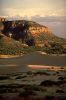
Moquith Mountain is a small plateau reaching about 7,000 feet and covered with thick stands of ponderosa pine mixed with Gambel oak and isolated stands of aspen. From its heights are expansive vistas across the vivid pinks of the Coral Pink Sand Dunes, dotted with rich green islands of isolated ponderosa pine groves, to the equally stunning colors of the White and the Pink Cliffs to the north. To the east are views into the cliffs and canyons of the area, covered with pinyon and juniper, and beyond to distant mesas and cliffs. The canyon rims offer vertiginous views of sheer, desert-varnish-streaked walls which line narrow, rushing streamcourses.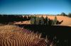 Along the rims, the brilliant green of manzanita stands out against the vivid redrock, which is dotted with the blue-grey of the banana yucca and the dark, rounded forms of blackbrush. Many of the signature plants of the Upper Sonoran zone are represented along the rims and in the canyons: rabbitbrush, cliffrose, littleleaf mountain mahogany, Apache-plume, etc. Boxelder and cottonwood grow along the eight miles of perennial streams in the canyons. The South Fork of Indian Canyon houses a magical hanging garden, the heads of two unnamed canyons harbor mysterious quaking aspen groves, and in Water Canyon, Douglas fir groves perch on north-facing ledges -- remnants of a colder and moister period.
Accessible only with ropes and rappelling skills, the 225 acres in Water Canyon and South Fork Indian Canyon represent two of the last relict riparian areas in the state. Tall rushes and grasses, including a number of unfamiliar species, grow in the stream itself. Hanging gardens, oak, maple, and Douglas fir thrive in this completely natural area.
The area contains Erigeron religiosus (a rare fleabane daisy of the Zion area), Asclepias welshii (a threatened milkweed), and Astragalus striatifious (a rare milkvetch). Wildlife includes the resident mule deer and cougar, cottontail rabbit, raven, mourning dove, and coyote. Three sensitive species live here: roadrunner, Lewis's woodpecker, and fox sparrow. Two endangered species, bald eagle and peregrine falcon, visit the area. The varied terrain provides an abundance of habitats that remain uninventoried even for a definitive species checklist, let alone for rare and endangered species.
Archeological surveys performed for the Southern Utah Coal Project revealed densities of over 50 sites per 23,000 acres. A thorough inventory of archeological sites would likely disclose many. The mysterious faces and figures of the South Fork Indian Canyon pictographs are the best-known evidence of prehistoric rock art in the area.
A Silent World
Two developed campgrounds and several undeveloped campgrounds bordering the area provide good starting points for day hikes and backpacks into the area. The top of Moquith Mountain and the South Fork Indian Creek-Water Canyon area are favored destinations. One does not have to venture far to find oneself in a silent and pristine world, broken only by the croak of a raven or the rush of wind in the pinetops. The area is part of the BLM's 50,632-acre Moquith Mountain Special Recreation Management Area. The agency states that "educational values are particularly significant because they are diverse, conveniently concentrated in a small area and accessible."Machines Over Wilderness?
The BLM recommended against wilderness for its 14,830-acre Moquith Mountain WSA. No rationale was given, although off-road vehicle use is permitted in three-fourths of the area. A sandy way leads to the top of Moquith Mountain and another to the South Fork of Indian Canyon. Vehicles branching off these routes have created ruts and scars in the sand dune areas, but these are slowly being reclaimed by cryptogamic soil and grasses. These vehicles, however, continue to run across the small population of the threatened milkvetch identified in the area.Few other conflicts exist. The BLM cites an antique corral, nine miles of fence, three spring developments, one windmill, and some stumps and logs here and there, but these are substantially unnoticeable or are on the edge of the unit. The trend, however, appears to be towards further degradation of this outstanding ecosystem through continued ORV use and woodcutting -- activities readily available in surrounding developed areas.
The Utah Wilderness Coalition Proposal
We recommend wilderness designation for a 26,500-acre area, including additions to the BLM's WSA in the Cottonwood Creek drainage and to the northeast of the WSA. In Cottonwood Canyon we cherrystem a road and pipe to the BLM's boundary, including in our proposal the east side of the canyon. Although ORV use in the area is currently small, its use as a motorized playground will lead to the area's degradation. Wilderness status would protect fragile sand dune and cryptogamic soil areas from damage (the BLM notes that 56 percent of soils in its WSA fall into the severe or critical erosion class). Since ORV users have free access to the adjacent state park, it is reasonable to reserve the Moquith Mountain area for those who want to enjoy its superb scenery and unique life forms in peace.Dave Hamilton
