THE SAN JUAN-ANASAZI WILDERNESS
- Anasazi Country
- Booming Recreation
- Arch Canyon -- Focus of Conflict
- The Utah Wilderness Coalition Proposal
- NOKAI DOME UNIT
- GRAND GULCH UNIT
- FISH AND OWL CREEK CANYONS UNIT
- ROAD CANYON UNIT
- SAN JUAN RIVER (SUGARLOAF) UNIT
- COMB RIDGE UNIT
- ARCH AND MULE CANYONS UNIT
 It is difficult to imagine the Mormon pioneers crossing this rugged country in horse-drawn wagons, coming upon half-mile-wide gashes stretching across the landscape. Their route to the settlements at Bluff is now a historic trail. Archeological researchers are uncovering evidence of far older roads used by the enigmatic Anasazi Indian culture, which occupied most of this area.
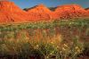
Today the San Juan-Anasazi wilderness is one of the most popular destinations in Utah for backcountry visitors. Canyon adventurers often see Anasazi ruins as they hike through this enormous outdoor museum. The area is also biologically diverse, with streams and riparian vegetation complementing the lovely forests of Cedar Mesa and providing habitat for wildlife including deer, cougar, and many bird species.
As in much of southeastern Utah, unrestricted vehicle access has allowed pothunters to vandalize ancient ruins and off-road-vehicle users to tear up fragile soils. To protect the public's land from the abuses of the few, the Utah Wilderness Coalition proposes 395,800 acres of wilderness in seven units, ranging from the wide-open slickrock of Nokai Dome to the startling bare-rock spine of Comb Ridge.
Anasazi Country
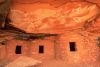
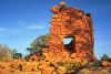
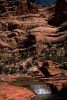
Although the Anasazi left the area 700 years ago, their traces still exist in such deep canyons as Arch, Slickhorn, Grand Gulch, Fish, Owl, and Mule. Cliff dwellings made of mud and stone perch like swallow's nests on south-facing canyon exposures. In several canyons, stone towers once housed the Indians, and on the ground nearby, scatterings of broken pottery, along with corncobs and gourds desiccated by a thousand summers, hint at the daily lives of these desert dwellers. Circular kivas where the Anasazi gathered underground for religious ceremony, and curious pictographs on the sandstone walls are evidence of their spiritual legacy.Recently discovered along Comb Wash near the mouth of Arch and Mule canyons is a continuous series of sites that the Anasazi used intensively. Some of these structures may have rivaled those found at Chaco Canyon, according to a BLM archeologist. The area has been likened to a prehistoric city whose presence was unsuspected a few years ago. An ancient road system that apparently connected habitation sites may change our fundamental understanding of the Anasazi culture. Much remains unknown about the Anasazi, and many potentially important archeological sites await discovery. Accordingly, it is important to protect this former homeland of the Anasazi from indiscriminate development.
The concentration of archeological sites in this region, up to several hundred per square mile, may be as great as anywhere in the United States. Unfortunately, most of these sites are vulnerable to pothunters, and many of the important ruins have been vandalized already. Looters continue to steal valuable artifacts, yet the BLM is not adequately funded, staffed, or motivated to protect the cultural values on its lands. Although the BLM established the 33,000-acre Grand Gulch Primitive Area in 1974 to protect the archeological resources of the area, little money is allocated to protect the sites through education and law enforcement.
 The BLM recently proposed to manage 400,000 acres of Cedar Mesa as a National Conservation Area (NCA). Accompanying this congressional designation would be increased funding to stabilize ruins, additional rangers to educate people and protect sites, a visitor center, and better trail management. However, the NCA would not necessarily preclude motorized access to sensitive archeological sites, limit mining exploration and development, or disallow "chaining" projects, which uproot trees and may destroy archeological sites to create artificial cattle pasture. If the legislation were accompanied by wilderness designation, these problems could be overcome.
Much of Cedar Mesa's cultural heritage is unprotected. If local officials had their way, it is likely that several of the ancient Anasazi roads would become county roads for automobiles, and much of Cedar Mesa would be open for unrestricted oil and gas development. The Utah Wilderness Coalition's proposal will help protect many of the ancient roads and structures by making them less easily accessible to vandals. The UWC proposal would also preclude new road construction in the wilderness.
Booming Recreation
| Southeastern Utah seems destined to have many visitors who are attracted by the scenery of a region remote from main lines of travel . . . . the exceptionally interesting trail through the Clay Hills, Castle Wash, Wilson Mesa, and across the San Juan to Navajo Mountain, and the trail through the Henry Mountains and the Kaiparowits region to Escalante, are feasible for adventurers who place unusual experiences above daily comforts.
Herbert Gregory |
In contrast to these busy canyons, the western part of the San Juan-Anasazi wilderness, the remote and austere Nokai Dome unit, is visited infrequently and offers complete solitude. Adjacent to the San Juan arm of the Glen Canyon National Recreation Area, this unit contains the long, deep forks of Mikes Canyon and the rolling slickrock-and-sand expanse of Grey Mesa, which the historic Mormon Trail traverses.
Arch Canyon -- Focus of Conflict
The greatest controversy over the use of this area, however, is on its northeastern edge below the Abajo Mountains. Arch Canyon, a deep sandstone gorge that contains three natural stone arches, many archeological sites, several interesting sidecanyons, a perennial stream, and a variety of wildlife, was recommended for designation as a National Monument by the National Park Service in 1937. Its appeal as a recreational area is undeniable, and it is heavily used by hikers, hunters, and horse riders. Unfortunately, Arch Canyon has also come to symbolize the difficulties facing the public's wild lands. The canyon's solitude, archeological values, and riparian areas are threatened by growing off-road vehicle use; its water supplies have been fouled periodically and its vegetation overgrazed.Narrow canyon bottoms with delicate riparian areas such as in Arch Canyon are simply no place for motorized vehicles or heavy cattle grazing. In 1989, the Chrysler Corporation began sponsoring an annual "Jeep Jamboree" in Arch Canyon. This gathering of ORVs threatens to tear up wild country and damage natural resources on a regular basis. Conservationists are fighting to keep repeated vehicle use from creating a road up Arch Canyon, and have asked the BLM to reduce or eliminate livestock grazing in Arch Canyon (whether or not it is designated wilderness). The Grand Gulch Primitive Area, which has been managed to exclude domestic livestock and ORVs, offers a good example of what such management can do in just a few years. In Grand Gulch, the grasses are denser and more diverse, streamside vegetation more luxuriant, erosion diminished, and wildlife more abundant than in nearby canyons.
The Utah Wilderness Coalition Proposal
The Utah Wilderness Coalition advocates leaving the San Juan-Anasazi area as close to its natural condition as possible by designating a wilderness area of 395,800 acres. The BLM would protect only 204,090 acres, missing all of the Nokai Dome unit, all of Arch Canyon, the wild slopes north of the San Juan River between Bluff and Mexican Hat, and much roadless land in three of the four remaining units. Full protection of the area is needed to safeguard its priceless archeological resources and ensure opportunities for low-impact backcountry recreation.NOKAI DOME UNIT
Highlights
Sixty miles west of Blanding lies the 100,400-acre Nokai Dome unit, one of the most remote areas in Utah. Contiguous with the San Juan River arm of the Glen Canyon National Recreation Area, this rugged and lonely land contains numerous deep canyons, scenic expanses of slickrock, and breathtaking vistas of the surrounding country. Experienced hikers will find challenging terrain in Mikes, Castle, and Lake canyons, and desert bighorn find here their yearlong habitat.Geology and landforms
A vast expanse of sandstone of the Mesozoic and Paleozoic eras, the Nokai Dome unit slopes gradually down to Lake Powell. Slickrock and sandblow dominate the uplands. Mikes Canyon and Castle Creek, which both harbor rare spring-fed streams, have cut cliffs into the sandstone. Lake Canyon provides a water source in the northwestern corner. Views from Nokai Dome include Navajo Mountain to the southwest, the Waterpocket Fold to the northwest, and the spires of Monument Valley to the south. Highway 263, which is the northern boundary of the unit, is managed as a scenic highway corridor.Plant communities
Some pinyon-juniper is found at higher elevations, but blackbrush and associated desert shrubs dominate the unit. Small but delightful areas of riparian habitat are found in the bottom of Mikes, Castle, and Lake canyons and some of their tributaries. The Clay Hills support some grassy parks.Wildlife
The Nokai Dome unit is part of the yearlong habitat of the desert bighorn sheep (BLM, 1986a, p. 3-43) and is also habitat for a number of desert species, including the endangered peregrine falcon. Beaver are found in riparian areas.Archeology and history
Although this unit has not been thoroughly inventoried, it was used by Archaic, Basketmaker, and Anasazi cultures. The lower canyons have numerous storage structures and some habitation sites; stone chipping and camping sites are found on the benchlands. The historic Hole-in-the-Rock Trail, where a group of Mormons trekked to Bluff, Utah, cuts across the western portion of the unit.Recreation
Visitation to Nokai Dome is limited owing to its remote and untamed nature. Water is limited to a few cliffside springs and the lower reaches of the canyons, but if one is well prepared, there are exceptional hiking and backpacking opportunities. Mikes Canyon can be reached via its upper tributaries or overland from the Clay Hills road; Castle Creek and Nokai Dome itself can be reached via four-wheel-drive routes. The solitude in this unit is almost more than one can bear. The views of the Henrys, the Little Rockies, Lake Powell, and the surrounding countryside are unparalleled in the Plateau country.BLM recommendation
The BLM declined to study this vast expanse of wild land for its wilderness potential, claiming that the area was heavily impacted by mineral exploration. It divided the unit into four small parcels and dropped each from its wilderness inventory. The subdivision of the unit along various vehicle ways violated the BLM's wilderness inventory policy. The Hole-in-the-Rock Trail, a four-wheel-drive vehicle route, is not maintained as a road. The way along Castle Creek follows a sandy wash impassable to passenger vehicles. A mineral exploration road up onto Nokai Dome itself was bladed in places but is now limited to four-wheel-drive vehicles.Coalition proposal
We propose 93,400 acres of wilderness. Our boundary cherrystems the vehicle ways noted above, including the historic Mormon Trail, a popular off-highway route in the area. Mining exploration tracks and drill pads in the unit are largely overgrown, eroded, or blown over with sand and do not significantly affect the unit's wildness. If natural reclamation were given some assistance, these scars would continue to fade. Rather than cast out the entire unit because of past bulldozing and drilling in a few areas, we should allow the tremendous wild character of the region to reestablish itself.GRAND GULCH UNIT
Highlights
Grand Gulch, one of the most popular hiking areas in the state, is the centerpiece of the 139,800-acre Grand Gulch roadless area. Other, less-visited canyons are also cut into the broad upland that slopes southwest from Highway 95 to the San Juan River. The unit has hundreds of miles of canyons and sidecanyons, thousands of archeological sites (many of them threatened by abuse and misuse), and important desert bighorn habitat.Geology and landforms
Johns Canyon, Slickhorn Canyon, and Grand Gulch are cut into the 800-foot-thick Cedar Mesa Sandstone of Permian age. These canyons have also exposed older Pennsylvanian rocks in their lower stretches before reaching the San Juan River. Deep overhangs and alcoves line these canyons and their tributaries, many of which shelter Anasazi dwellings. Downstream from Grand Gulch, Steer Gulch and Whirlwind Draw enter the San Juan. The broad upland benches that separate the canyons range in elevation from 6,600 feet in the northeast at Grand Flat to 4,100 feet in the southwest at the Clay Hills road.Plant communities
A pinyon-juniper forest dotted with sagebrush parks covers more than half of the unit. The more arid blackbrush-desert shrub community is found at lower elevations to the southwest. Grand Gulch, Slickhorn, and Johns Canyon flow during most of the year and contain riparian habitat such as cottonwood and willow. The BLM's WSA includes four sensitive species, the milkvetches Astragalus cottamii and Astragalus monumentalis, the Kachina daisy (Erigeron kachinensis), and the death camas (Zigadenus vaginatus) (BLM, 1986, p. 15.)Wildlife
The unit encompasses nearly 3,000 acres of crucial deer winter range, according to the BLM, and mule deer inhabit some of the canyons year round. Although bighorn have not been abundant in recent years, 3,900 acres of crucial bighorn range are also found in the unit. Spotted skunk and ringtail cat live in the wetter canyons, and the unit is home to a number of small mammals and birds. The endangered bald eagle spends its winters here.Archeology and history
This unit houses a "wealth of pristine Anasazi cultural resources" (BLM, 1986, p. 19). Nearly 600 archeological sites have been recorded from both the Basketmaker and Pueblo cultures of the Anasazi, and the BLM estimates that its WSA alone may contain more than 11,000 additional unrecorded sites, three-fourths of which could be eligible for the National Register. Unfortunately, vandalism is a serious problem, and the footfalls of thousands of well-meaning visitors have also disturbed many sites. Elsewhere in the unit, the Hole-in-the-Rock Trail marks the passage of early Mormon settlers on their way to Bluff, Utah, in 1879.Recreation
Hiking, backpacking, camping, horseback riding, and the study of archeology and nature drew an estimated 20,000 visitor days of use in 1985, up from 2,000 a scant 11 years earlier (BLM, 1986, p. 20). The BLM has attempted to redirect some traffic to neighboring wild lands that offer equally grand hiking and greater solitude; we suggest visiting Grand Gulch during the late fall or early spring, when crowds are smaller and the lighting on the rocks is sublime. Alternatively, try the outlying canyons such as Steer Gulch or Whirlwind Draw. In past years, a permanent BLM ranger, assisted by six or seven temporary staff, were on hand to manage traffic and educate visitors about protecting the Anasazi ruins. Recent budget cuts have left only one seasonal ranger and some volunteers -- hardly the protection this superb area deserves. All this at a time when the agency is drawing plans for huge, budget-draining forest chainings elsewhere in the area.BLM recommendation
The BLM recommends that all of its 105,520-acre WSA be designated wilderness. But the agency dropped from its initial inventory 40,000 acres of roadless lands, including the upper part of Grand Gulch and the western part of the area around Steer Gulch and Whirlwind Draw. There are no known mineral conflicts in this area, and it is as wild as the WSA -- perhaps more so.Coalition proposal
We propose a 139,800-acre wilderness unit, including the roadless land that the BLM dropped from its inventory. A half-dozen old vehicle ways, totalling about 16 miles in length, are included in both the BLM's proposal and ours. The BLM has closed these to vehicle use. The unit retains its overall sense of naturalness and remains the central part of our San Juan-Anasazi wilderness, linking the slickrock mesas of the Nokai Dome unit with the rest of Cedar Mesa to the east.FISH AND OWL CREEK CANYONS UNIT
Highlights
The canyons of Fish Creek and Owl Creek, as well as the less well-known but also beautiful canyons of Dry Wash and lower Mule Creek, harbor important archeological resources worthy of protection. Our 59,000-acre wilderness unit would help protect these endangered resources as well as a popular backpacking area. The unit is located in the southeastern part of Cedar Mesa and forms a wilderness stretching from Comb Ridge to the Grand Gulch Plateau. The unit is encircled by the rest of the San Juan-Anasazi wilderness and is separated from the Comb Ridge and Road Canyon units by only a single dirt road.Geology and landforms
Fish Creek and its western tributary, Owl Creek, are steep-sided, narrow canyons cut into the southeast-dipping Cedar Mesa Sandstone, the only formation with significant exposure in the unit. Dry Wash and lower Mule Canyon drain the eastern part of the unit and, like Fish Creek, flow to the southeast into Comb Wash. In places the slickrock walls are 600 to 800 feet high; prominent arches also occur. The continuous vertical cliffs formed in the Cedar Mesa Sandstone permit access into the canyons only at a few breakdowns. The twists and turns of the canyons give an intimate feeling, whereas on the mesa tops one can see across the canyons to the imposing west face of Comb Ridge.Plant communities
Dense stands of pinyon and juniper cover most of the uplands in the unit, broken by sagebrush parks and some expanses of bare slickrock. This is the forest that lends all of Cedar Mesa its inviting appearance, less harsh than lower-elevation desert canyons. The BLM (1986) reports four candidate threatened and endangered species, the milkvetches Astragalus cottamii and Astragalus monumentalis, the Kachina daisy (Erigeron kachinensis), and the death camas (Zigadenus vaginatus). Riparian habitat is found along the creek bottoms; the BLM (1986a) lists a potential Area of Critical Environmental Concern for riparian habitat in Fish Creek, Owl Creek, and Butler Wash.Wildlife
The unit provides seasonal habitat for mule deer and the endangered bald eagle. Petroglyphs indicate that the area was once desert bighorn habitat; their reintroduction should be considered.Archeology and history
The entire unit was heavily used for agriculture by the Anasazi people; near-perfect kivas and cliff dwellings can be found in Fish and Owl Creek, as well as numerous burial and chipping sites. Undisturbed Basketmaker sites are also present. The mesa tops above Mule Canyon and the cliff walls themselves contain one of the greatest densities of archeological sites in the United States. The historic Hole-In-The-Rock pioneer trail forms the southwestern boundary of the unit.Recreation
Fish and Owl Creek Canyon are among the most popular backpacking areas on Cedar Mesa. Multi-day backpacking trips take in a loop of these canyons, passing through twisting, narrow slickrock walls. For years the BLM encouraged use of this area as an "overflow" from Grand Gulch. Use has increased steadily from about 2,500 visitor-days in 1980 to 6,160 in 1984 (BLM, 1986, p. 18). Outfitting makes up a significant proportion of these totals. Lower Mule and Dry Wash canyons are shorter, less traveled, and provide outstanding opportunities for solitude on day hikes. The mouths of all of these canyons can be reached by hiking west from the dirt road that runs along Comb Wash between Utah Highway 95 and U.S. 163. This road is passable to two-wheel-drive vehicles in dry weather, but rainstorms may necessitate four-wheel-drive. Cars can also be parked at the Kane Gulch Ranger Station atop Cedar Mesa on Utah 261 for round-trip hikes through Fish and Owl Creek Canyon.BLM recommendation
The BLM initially recommended that 35,220 acres out of its 46,440-acre WSA be designated as wilderness. Its final recommendation is expected to be 40,160 acres. Following agency custom, the slightly less rugged eastern parts of the unit were excluded, part during the initial inventory and part during the WSA study. Much of this area is proposed for costly, destructive forest chaining. The BLM's arbitrary WSA boundary left out the archeologically rich lower part of Mule Canyon, as well as Baullie's Bench and Dry Wash. The claim was that these areas lacked outstanding opportunities for solitude. Oil and gas leases cover much of the unit, despite its high wilderness values; in fact, the BLM has allowed drilling in an area they had recorded as habitat for the endangered bald eagle. However, the potential for mineral resources is low due to unfavorable geologic conditions.Coalition proposal
We propose a 59,000-acre wilderness unit, restoring to protection the lands BLM deleted in lower Mule Creek, Dry Wash, and Baullie's Bench. Despite the agency's claim, excellent solitude is to be found on those lands, not just in areas of dense vegetation or behind steep canyon walls. Like the mesa tops, the natural open areas surrounding the mouths of the canyons are integral to the unit. Our proposal excludes intrusions along the seven-mile-long Comb Wash overlook road, which extends between Dry Wash and Mule Canyon. A cherrystem excludes the two-mile-long road extending west from the eastern boundary and a two-mile-long road extending northwest between Fish Creek and Dry Wash.ROAD CANYON UNIT
Highlights
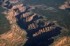
This 60,100-acre unit, which forms the south-central block of the San Juan-Anasazi wilderness, includes the narrow slickrock canyons of Road Canyon and Lime Creek. The unit's name is a misnomer; there are no roads in Road Canyon. The unit is separated from the adjoining Comb Ridge and Fish and Owl Creek units by a single four-wheel-drive road. A two-wheel-drive road taking off from the Valley of the Gods loop road (off of U.S. Highway 163 and Utah 261 north of Mexican Hat) gives access to the main fork and west fork of Lime Creek Canyon. The upper ends of these canyons as well as Road Canyon itself can be reached from Utah 261 on top of Cedar Mesa, and the mouths of Road and Barton canyons can be reached from U.S. 163 via a dirt road that begins just north of the bridge over Comb Wash.Geology and landforms
The edge of Cedar Mesa, which bisects this unit, abruptly drops 1,000 feet in places. The view from the mesa rim takes in the isolated monoliths and rock fingers of the Valley of the Gods, the huge Raplee Anticline rising over the San Juan River, and distant mountains in Colorado and New Mexico. (Summer visibility averages 100 to 130 miles.) Cutting across the mesa top are narrow, sinuous stair-stepped sandstone chasms, in their upper reaches 600 to 800 feet deep. To the south these canyons enter an area of brittle, deep red to purple Halgaito Shale before draining out into the expanse of the Valley of the Gods. A beautiful variety of colors and erosional forms is found here.Plant communities
The pinyon-juniper forest of Cedar Mesa carpets the upper parts of the unit with its dark, velvety green. As this plateau breaks off into canyon and desert floor, the forest is replaced by desert shrubs. According to the BLM, two threatened or endangered candidate species, the milkvetch Astragalus cronquistii and the daisy Erigonum clavellatum may live in the unit (BLM, 1986, p. 16).Wildlife
Like the Fish and Owl Creek unit to the north, Road Canyon is populated by a typical variety of wildlife, including the elusive cougar, some deer, and migrant bald eagles. Bighorn sheep have used the area in former years, according to the BLM (1986); however, there are no plans to reestablish their populations.Archeology and history
There are well-preserved Anasazi and Basketmaker sites in the canyons and mesa tops. Limited surveys in the area suggest that the unit may contain more than 6,000 archeological sites, with more than 4,000 possibly eligible for the National Register (BLM, 1986, p. 21). The historic Hole-In-The-Rock Trail, a Mormon pioneer route, borders the unit on the northeast.Recreation
Road Canyon and Lime Creek Canyon, the two major drainages in the unit, offer excellent overnight hikes. Far fewer people visit this unit than the neighboring Grand Gulch and Fish and Owl Creek units. The BLM estimates use at only a few hundred visitor days per year, most of which are part of the educational programs of the National Outdoor Leadership School. The full length of Road and Lime Creek canyons can be hiked, although a 50-foot pouroff in lower Lime Creek requires routefinding through a natural rock tunnel. The strange, multicolored badlands between Barton Canyon and Comb Wash make fascinating exploration.BLM recommendation
To its credit, the BLM recommended 45,720 acres of its 52,420-acre WSA for wilderness, and has announced that it will recommend all of the WSA in its final EIS. Earlier, the BLM had inexplicably dropped from its inventory the benches and badlands between Barton Canyon and Comb Wash. There are numerous oil and gas leases in the unit, but their development potential appears to be low.Coalition proposal
We propose a 60,100-acre wilderness unit encompassing the desert benchlands that the BLM deleted, including some of the pinnacles, escarpments, and peaks within the Valley of the Gods. The rolling landscape provides excellent screening from other users, enhancing the sense of seclusion. Wilderness designation is needed to prevent ORV use from disturbing fragile soils and solitude. Our proposal cherrystems the dirt road running between Road and Lime Creek canyons. There appear to be no other conflicts with wilderness designation.SAN JUAN RIVER (SUGARLOAF) UNIT
Highlights
The float trip down the San Juan River from Bluff to Mexican Hat passes between the Navajo Reservation and BLM land to form the southernmost boundary of the San Juan-Anasazi wilderness. The BLM side was not studied for its wilderness potential, despite its high scenic and recreational values. The unit also includes the plateau between the river and Highway 163. A hiker can travel a portion of the waterway by entering the canyon where the river exits from the Raplee anticline, known locally as the Navajo Rug, and the upland region can be reached from the north by dirt roads leaving Highway 163 near the crest of Lime Ridge. An alternative take-out is near Mexican Hat Rock, where a rough sandy road reaches the river and forms the downstream unit terminus.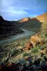
Geology and landforms
The San Juan River cuts deeply through Pennsylvanian sedimentary rocks some 300 million years old. The Lime Ridge and Raplee anticlines are bisected by the river and form walls up to 800 feet high. Bioherms -- ancient mudbanks with heavy concentrations of algae and other fossils -- can be found along the canyon bottom. An enormous abandoned river meander, with the imposing pinnacle of Sugarloaf Butte rising from its center, lies in the interior of the unit. The sandy bottomed river falls at a rate greater than that of the Colorado River in the Grand Canyon, and the combination of high gradient and heavy sediment loading results in sand waves, an uncommon phenomenon. For details on the geology of the area see Baars (1986).Plant communities
The mesas above the river are dominated by desert shrubs spaced widely apart on the often rocky soils. Some riparian vegetation is found along the river, with shady cottonwood stands near the upstream boundary of the unit. Box elder grows along some lazy turns of the canyon, and tamarisk is ever-present.Wildlife
Fox, coyotes, lizards, mountain lions, bighorn sheep, snakes, and eagles can be found in the unit. The river holds a population of channel catfish, among other aquatic species.Archeology and history
A unique Clovis point hunting site thousands of years old has been found on the edge of the unit on Lime Ridge. The Anasazi culture left little trace in the deep San Juan River canyon itself, but there are extensive rock art panels upstream from this unit and numerous cliff dwellings across the river on the Navajo Reservation in Chinle Wash. (Permission should be obtained before visiting those sites.)Recreation
The San Juan River is a popular float trip, with warm water and red rock scenery. The river is traveled by raft, kayak, and canoe; however, there are some rapids on this stretch, and any trip should include experienced river runners. Commercial outfitters offer guided trips. The float from Bluff to Mexican Hat can be done as a day or overnight trip. A hike across the plateau from Highway 163 towards Sugarloaf Butte provides stunning and seldom seen vistas down into the river canyon. Also worthy of a visit from the plateau is the abandoned rincon, which drops suddenly and spectacularly from the surrounding mesa.BLM recommendation
The BLM inexplicably failed to give this unit WSA status. It exaggerated the extent of a few localized impacts and incorrectly mapped nonexistent roads. It appears that the agency may have gotten carried away with a marking pen and cut the unit in half by drawing a road which, if it actually existed, would run from Highway 163 off the top of Lime Ridge and over several hundred feet of airspace above the river. Perhaps a developer would dream of such an architectural feat, but you'll find only the wide-open skies over the unit.Coalition proposal
We propose that 13,200 acres of the San Juan River Canyon be protected along the river from Comb Wash to Mexican Hat Rock and out to Highway 163 and the highway powerline corridor. Our unit would protect the multi-colored patterns formed by overlapping uplifted rocks on the west side of Comb Wash which have at various times been threatened by strip mining proposals. The unit would also help preserve the San Juan River corridor to ensure that a wilderness trip remains possible. The canyon has been considered as a reservoir site, although there are no serious proposals at this time. Our proposal cherrystems the dirt roads atop Lime Ridge.COMB RIDGE UNIT
Highlights
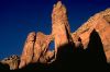
The scenic culmination of a drive on Utah's Highway 95 is the climb over Comb Ridge, one of the Southwest's most spectacular geologic features. But those who get out of their vehicles and wander south along the ridge discover still more magnificent vistas, as well as hidden sidecanyons offering quiet seclusion. We propose a 15,000-acre wilderness unit, about 15 miles long by 1-1/2 miles wide, forming the eastern border of the San Juan-Anasazi wilderness. Access is easy from Highway 95 at the unit's north end or Highway 163 at its south end, and from the dirt road along Butler Wash. The approach to the ridge's sheer western wall is best left to the hawks and eagles that frequent the unit.Geology and landforms
Comb Ridge is a 600-foot-high sandstone monocline that runs in a north-south direction for nearly 90 miles, curving west past Kayenta, Arizona. The ridge's greatest expression is within the proposed wilderness unit, where its near-vertical western wall and gentler eastern slope are visible from many vantage points in the region. From its top are 360-degree views taking in the Abajos, Cedar Mesa, the patterned badlands below Bartlett Canyon, the spires of Monument Valley, and the Mule's Ear above the San Juan River. Comb Ridge itself is visible stretching toward the Abajos to the north and the San Juan River to the south. The east flank of the ridge is cut by many short canyons, most of them straight, narrow, and secluded.Plant communities
Only the occasional hardy shrub or juniper grows on the exposed sandstone of Comb Ridge. The more gradual eastern slope, however, hosts a scattering of pinyon and juniper trees and their associated desert shrubs.Wildlife
Comb Ridge is prime raptor habitat and the birds can be seen wheeling and diving along the precipitous face of the ridge. Deer also inhabit the unit.Archeology and history
Archeological sites are found in rifts along the side of the ridge. In places Anasazi footholds are cut into the stone.Recreation
A hike up the sloping slickrock to the edge of Comb Ridge pays off in fabulous views. Hikers can track the high edge of the ridge for most of the unit's 15-mile length but should use discretion and choose their route carefully. The west face of the ridge offers challenging rock climbs for expert climbers. While the top of the ridge draws attention with its high profile, the short, narrow sidecanyons on its eastern flank are subtle and secret. A shady green pool lies below Monarch Cave, awaiting swimmers on a scorching afternoon.BLM recommendation
The BLM dropped Comb Ridge from its wilderness inventory, alleging that the unit is too small to offer solitude and primitive recreation. But exploration of the unit reveals just those qualities: it is extremely rugged and the topography provides secluded spots as well as grand vistas, with plenty of challenge for hikers and climbers.Coalition proposal
We propose a 15,000-acre wilderness unit and know of no conflicts with wilderness designation.ARCH AND MULE CANYONS UNIT
Highlights
This 15,300-acre unit begins as a slice through a great dome of slickrock rising above Comb Wash and then trails up into tall groves of ponderosa pine where impressive natural arches stand. The upper four miles of Arch Canyon are part of a roadless area under Forest Service management. Undisturbed cliff dwellings in both Arch and Mule canyons bespeak the Anasazi culture. Hiking opportunities are excellent, and the scenery is unmatched. The National Park Service recommended National Monument protection for Arch Canyon as early as 1937. Access is from Highway 95 and the road up Comb Wash.