THE DIRTY DEVIL WILDERNESS
- At the Edge of The Block
- Abundant Wilderness
- The Mining Invasion
- Red Carpet for Tar Sand?
- Conservation or Exploitation?
- DIRTY DEVIL-FRENCH SPRING UNIT
- FIDDLER BUTTE UNIT
 The primitive beauty of the Dirty Devil country has inspired proposals for national monument, national park, and wild and scenic river designations. In 1965 some 50,000 acres surrounding the lower Dirty Devil River canyon were included in the Glen Canyon National Recreation Area. The remainder of the canyon system lies on BLM land. Yet, despite strong public support for protecting the entire region, the BLM has failed to recognize its importance. The agency's wilderness recommendations omit two-thirds of the BLM-managed wild lands in the Dirty Devil region. Instead of protecting these lands, the BLM proposes to open them for uranium and tar sand development, creating a 100-square-mile mining and industrial zone at the heart of the canyon system.
Such development would destroy forever the primitive character of the Dirty Devil region. It is one wilderness, with a scenic, recreational, and bioregional integrity that reaches from canyon rim to canyon rim. The Utah Wilderness Coalition's 263,500-acre proposal would protect that integrity for future generations.
At the Edge of The Block
Deep within the Dirty Devil River canyons lies a mesa called "The Block." It is a formidable object, a thousand-foot-high fortress with cliff walls curving inward to form deep bays and coves and reaching outward as jetty-like arms. A dense forest of juniper and pinyon pine carpets the 5,000-acre mesa top. Deer, bighorn, and an occasional human visitor climb the single foot trail that leads up through the cliffs to the summit.
| The outlaws would rustle their cattle into [Robbers] Roost, which was a five-mile circular flat that had lookout points on all sides . . . . Isolated from settlements by miles of desert and box canyons, it was almost inaccessible except to the few that knew the route . . . . It was a fortressed triangle of deep canyons, rivers and mesas and perfectly suited the needs of the outlaws.
Robert Redford |
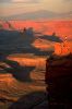
One by one, the landmarks burn with light. To the north lies The Big Ridge, a thousand-foot-high, fifteen-mile-long land bridge that forms the northern wall of Fiddler Cove. Massive buttes and pyramids rise from the floor of the Cove and, at its center, spiked by a lightning-strobe, stands Fiddler Butte, a sphinx-like monolith 900 feet high. Thunder rolls across the Cove, roaring like surf against its walls. To the west, the Henry Mountains seem to rise and fall against a backdrop of intermittent green light. On the northern horizon, a pink flash silhouettes the San Rafael Reef, Factory Butte, and the black hulk of Thousand Lake Mountain.
Somewhere below, lost in shadow, the Dirty Devil River trickles quietly between 500-foot-high canyon walls on its 90-mile journey from Hanksville to the Colorado River.
Abundant Wilderness
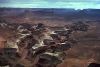
For centuries the Dirty Devil canyon system has been a barrier to civilization, a 300,000-acre wilderness suspended between sheer walls. It remains so today. Here one can find, in abundant supply, all that one could hope for in wilderness. The landscape is an infinite series of novel and beautiful shapes. There are colorful cliffs, winding slot canyons, rincons, alcoves, pools, waterfalls, buttes, towers, domes, spires, and arches. During the spring snowmelt boaters ride the length of the river in kayaks and canoes. Hikers and climbers find still more adventure; a recent guidebook (Kelsey, 1987a) features 200 miles of backcountry hiking routes within the Dirty Devil canyon system.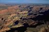 The entire Dirty Devil area provides important habitat for wildlife. Herds of antelope roam the plateau country along both canyon rims. Remote sidecanyons harbor rare populations of beaver, desert bighorn sheep, and at least nine species of plants and animals which the BLM has identified as "sensitive." Prehistoric artifacts are abundant here, as they are throughout the Colorado Plateau. Recent studies by the National Park Service and the BLM (1984) suggest an average density of 24 archeological sites per square mile, or up to 11,000 rock shelters, campsites, lithic scatters, stone tool quarries, and petroglyph sites throughout the Dirty Devil region.
Since the 1930s, there has been a series of proposals for preserving the primitive character of the Dirty Devil canyons. In 1936, Wilderness Society founder Bob Marshall identified the Dirty Devil canyons as an integral part of the 8.9-million-acre Colorado River canyons roadless area -- the largest remaining block of wilderness in the lower forty-eight states. In the same year, the U.S. Department of the Interior launched a proposal to create a 4.5-million-acre Escalante National Monument in Utah. The monument's western boundary would have included nearly 200,000 acres surrounding the lower Dirty Devil River canyon. A 1961 proposal by Interior Secretary Stewart Udall would have included some 37,000 acres of the Dirty Devil region within Canyonlands National Park. In 1970, the BLM identified a candidate Dirty Devil primitive area of over 300,000 acres, and by 1979 the National Park Service had identified the entire length of the Dirty Devil River as a potential addition to the National Wild and Scenic River System.
The Mining Invasion
| Instead of blocking new development on lands under study for wilderness designation, the BLM had become an agent for development. Even |
Virtually all of the new roadwork was illegal, for Cotter Corporation had failed to apply for road right-of-way and drilling permits, as required by law. Where such developments might permanently impair the wilderness character of lands under review, they were strictly forbidden by the BLM's wilderness inventory regulations. Yet only after conservationists discovered the new roads did the BLM finally intervene. A 1979 BLM lawsuit forced the company to fully reclaim any new roadwork within the Dirty Devil WSA. Faced with the costs of repairing its damage -- and a sharply declining market for uranium -- Cotter abruptly canceled its exploration program.
Meanwhile the BLM was conducting its wilderness inventory. In response to the pressure from Cotter, the agency rushed to eliminate huge blocks of land from the inventory. During a special "accelerated inventory," the BLM reduced the original roadless area of more than 400,000 acres to three separate fragments: a 61,000-acre Dirty Devil WSA, a 25,000-acre French Springs-Happy Canyon WSA, and a 27,000-acre Fiddler Butte WSA. Between the three WSAs, and precisely at the center of the Dirty Devil canyon system, the BLM dropped from wilderness study nearly 100,000 acres, including a 16-mile-long segment of the Dirty Devil River itself. The lands omitted contained many of the region's most striking landmarks, including Sam's Mesa, lower Happy Canyon, The Pinnacle, The Big Ridge, The Block, Fiddler Cove, and Fiddler Butte.
Thus began an eight-year-long war of wills between Utah conservationists and the BLM. Instead of blocking new development on lands under study for wilderness designation, the BLM had become an agent for development. Even inside its three wilderness inventory units, the BLM continued to authorize the construction of new roads, new drillpads, mine assessment work, and reservoir construction. Yet the BLM's mandate to preserve wilderness was clear and direct. Congress had specifically instructed the agency to protect all of its wild lands from new development while they remained under wilderness review. Utah conservationists fought back with protests and formal appeals. In 1983 and 1985, they won important victories before the Interior Board of Land Appeals (IBLA). The BLM had demonstrated no good reason, the IBLA ruled, for omitting Fiddler Butte from the Fiddler Butte WSA. The two successful appeals ultimately forced the BLM to add 47,000 acres to the WSA.
Red Carpet for Tar Sand?
Uranium exploration, wildcat oil wells, new road and reservoir construction -- all were serious threats to the primitive character of the Dirty Devil canyons. But by 1982, there was a new and far more dangerous threat. A coalition of 15 petroleum companies filed a proposal to develop a 66,000-acre tar sand mining complex spanning French Springs Canyon, Happy Canyon, The Big Ridge, and Fiddler Cove. The proposed development would have transformed the Dirty Devil region into a huge mining and industrial complex, causing environmental damage so thoroughly catastrophic that the BLM's 400-page environmental impact statement required more than 50 pages merely to describe it.Over the 160-year life of the project, a total of 35,000 injection and production wells would be bored throughout 54,000 acres of land. Subterranean explosions and fires would cause extensive subsurface fracturing over 39,000 acres, destroying natural aquifers and causing subsidence rockfalls and steam blowouts on cliff faces. More than 30,000 acres of soil would be disturbed, and 14,000 acres of land would be stripped completely of vegetation. Some 2,000 archeological sites would be disturbed. There would be a dam and reservoir on the Dirty Devil River and a water pipeline running the length of Happy Canyon. Hundreds of miles of roads would be built throughout Happy and French Springs canyons, The Big Ridge, and Fiddler Cove. There would be a bridge over the Dirty Devil River, and the Flint Trail -- a narrow, winding, adventurous jeep trail that climbs to the top of the Orange Cliffs -- would be crowned, ditched, and paved to accommodate some 600 vehicles per day.
On-site facilities would include five steam generation plants, an electrical power plant, coking, sulphur recovery, and sewage plants, oil storage tanks, a reservoir, and a solid waste dump. Noise levels would be high enough to cause hearing impairment within 600 feet of the extraction zone. The refinery's stack would dominate the western horizon of Canyonlands National Park, sending up a smoke plume by day and a halo of artificial lighting by night. Its emissions would regularly violate federal air quality standards within Arches and Canyonlands National Parks. Traffic, habitat disturbance, and noise would drive bighorn sheep, peregrine falcon, and other sensitive species of wildlife out of the region.
Even before the BLM had completed its environmental impact statement, a sharp downturn in worldwide oil prices put a sudden end to tar sand development in Utah.
In comparison to world oil reserves and national consumption, the entire oil reserves of the Dirty Devil region, even under the most optimistic estimates, are but a drop in the bucket. And oil from tar sand is much too costly to be economically viable in the foreseeable future. But if the world's resources of cheaper oil were depleted before alternative energy sources became viable, there could once again be a push to exploit the Dirty Devil tar sand deposits.
Conservation or Exploitation?
The energy companies -- and the BLM -- are betting on another energy crisis. They are betting against energy conservation, and they are betting against cleaner and more economical sources of energy. The BLM seems committed to tar sand development in the Dirty Devil region no matter what its environmental effect. That commitment is abundantly clear in the agency's wilderness recommendations. The BLM would omit 40,000 acres from the Fiddler Butte WSA so as "to reduce tar sand conflicts," as the recommendation flatly states. Most of the 25,000-acre French Springs WSA would be opened to development. "About 20,460 acres of the WSA are involved in lease conversion application for tar sand development," the BLM explained. "Development work, extraction, and patenting would be allowed...."Such development would destroy the wilderness character of the entire region. The Dirty Devil canyon system is one wilderness, with an esthetic and physical integrity that would be lost forever to a 60,000-acre tar sand mining complex. Gradually, after decades of erosion, the scattered mining impacts of the 1950s and the 1970s are being reclaimed and revegetated. Mudslides and gullies are slowly obliterating the Cotter Corporation's illegal road work on Sam's Mesa, in Happy Canyon, and along the Dirty Devil River gorge between Happy Canyon and Twin Corral Canyon. The Dirty Devil canyons remain triumphantly wild.
While the BLM has failed to recognize the importance of protecting the entire canyon system, the Utah Wilderness Coalition has made region-wide integrity its primary goal. Our 263,500-acre wilderness proposal would protect the entire Dirty Devil wilderness, healthy and intact, for future generations to explore.
DIRTY DEVIL-FRENCH SPRING UNIT
Highlights
In the 1890s, the Dirty Devil canyons were a hideout for Butch Cassidy and the Wild Bunch. Today these canyons still remain off the beaten path -- a place to elude civilization. There are 40 miles of river canyon and eight major sidecanyons up to 15 miles long with high, curved sandstone walls rivalling the Escalante in beauty. The BLM's 72,110-acre proposal leaves out spectacular Happy Canyon, the expansive tops of Sam's Mesa and the Big Ridge, and 16 incomparably beautiful miles of the river itself. The agency excluded these lands because of old roads which are now impassable, and because of highly unlikely tar sand development. By including them, the Utah Wilderness Coalition's 175,300-acre proposed Dirty Devil-French Spring unit, along with the Fiddler Butte unit, would protect the river's entire length from Hanksville to Lake Powell and all of its sidecanyons.Geology and landforms
Motorists on Utah Highway 95 south of Hanksville scarcely suspect that the low, reddish hills rising to the east conceal a vast canyon system lying beyond. The Dirty Devil River and its tributaries have carved as deep as 2,000 feet into the gently uplifted land, leaving a retreating series of cliffs and benches, a classic example of canyon lands topography. The slickrock sandstones of the Glen Canyon Group (Wingate, Kayenta, and Navajo formations) dominate the unit, but the lower river canyon and Happy Canyon have wide valleys in the Chinle clays and spectacular narrows in the White Rim sandstone. Dinosaur footprints are exposed on sandstone slabs in the unit.Plant communities
This is arid country broken by a handful of seeps and springs that support lovely hanging gardens and by the willow- and tamarisk-lined Dirty Devil River. Much of the unit is bare rock and sand. Large Fremont cottonwoods are found in sidecanyons, such as Robbers Roost, where flash floods and their remnant pools are the main water source. Elsewhere the overpowering dryness leaves the land to well-adapted species such as blackbrush, saltbush, shadscale, and ephedra, with juniper and pinyon growing at higher elevations and on mesa tops to the east. Sam's Mesa and The Big Ridge contain relict plant communities. Beaver Wash Canyon has 4,800 acres of near-relict riparian vegetation; although grazed by cattle, this clear-watered canyon supports willow, cattail, and sedge and provides excellent habitat for beaver and migratory waterfowl.Wildlife
Animals are similarly limited by scarce water here: there are some deer and antelope, and possibly desert bighorn sheep. A rare population of beavers has created dams along verdant Beaver Wash. Golden eagle use the area, and its cliffs provide excellent nesting sites for the endangered peregrine falcon, although no use is documented. The BLM notes that Bell's vireo, a sensitive species, may also be found here.Archeology and history
A relic of the Old West, the Dirty Devil wilderness provided a haven for bygone outlaws. Less well documented are rock art sites, granaries, and lithic scatters, some dating back to Archaic times. The limited surveys that have been done indicate that the entire unit probably contains thousands of sites, mostly those used by a nomadic rather than settled people.Recreation
The Dirty Devil River, a candidate for wild and scenic listing, may be floated during high runoff in kayaks, canoes, or small rafts; it makes an excellent backpack, too, either as a week-long trip down its entire length or as shorter trips via its sidecanyons. Kelsey (1987a) describes 11 hikes within the unit, some requiring skilled routefinding. The casual visitor can appreciate the magnificent view out over the canyons from Burr Point, at the end of a fairly good dirt road leading west from Highway 95 about 15 miles south of Hanksville. A pathway marked by stone cairns leads to the river from Angels Point.BLM recommendation
The BLM recommends designating the 61,000-acre Dirty Devil WSA and 11,110 acres of the 25,000-acre French Spring-Happy Canyon WSA. More than 83,000 acres, however, were not even studied. In the late 1970s, the Cotter Corporation illegally built over 20 miles of roads for uranium exploration in the southwestern portion of the unit. In the same area, old exploration roads and landing strips built in the 1950s had largely returned to nature and were impassable when FLPMA was passed in 1976. (The BLM's inventory policy required WSA boundaries to be based on the extent of impacts when FLPMA was passed.) But the BLM, in its answers to protests and an appeal by the Sierra Club, simply cited their mere existence as a reason for dropping the very center of the Dirty Devil canyons from further wilderness consideration and coincidentally dropping most of the new roads, too. It did this despite the requirements of the inventory policy to document the extent and nature of impacts at the time of FLPMA's passage. The new roads built by Cotter began to return to nature, too, so that vehicles once again could not reach Sam's Mesa or travel the roads in Happy Canyon or along the river -- at least until Wayne County road crews, acting without legal authorization, attempted to reconstruct parts of these roads onto Sam's Mesa. Because these roads traverse lands vital to the integrity of the region, they should be allowed to revegetate naturally.Coalition proposal
We propose a 175,300-acre wilderness unit. Commercial resources of hard-rock and leasable minerals are unlikely, according to the BLM, and the removal of energy minerals (including tar sand and uranium) would be prohibitively expensive and damaging to the environment (see area overview). Some old uranium exploration roads and landing strips from the 1950s are included, as is Cotter Corporation's illegal "upgrading" of those scars in the 1970s. Those roads are returning to nature and are generally impassable by vehicles. Rather than fracture the wilderness at Sam's Mesa (which was included in the BLM's draft WSA boundary in 1979), we propose a unified wild area surrounding the Dirty Devil and all of its major sidecanyons from just below Hanksville to the Fiddler Butte unit and the Glen Canyon National Recreation Area. Unlike the BLM's recommendation, our proposal includes undisturbed mesas, benches, cliffs, and canyon bottoms.FIDDLER BUTTE UNIT