THE KAIPAROWITS PLATEAU WILDERNESS
- No Trails, No Guidebooks
- Life in a Hard Place
- Coal Dreams
- Market Forces Halt Project
- The BLM Recommendation -- Driven by Coal
- Usurping the Role of Congress
- Abundant Coal -- Scarce Wilderness
- WAHWEAP-PARADISE CANYON UNIT
- NIPPLE BENCH UNIT
- WARM CREEK UNIT
- SQUAW CANYON UNIT
- BURNING HILLS UNIT
- FIFTYMILE MOUNTAIN UNIT
- FIFTYMILE BENCH AND CAVE POINT UNITS
- CARCASS CANYON UNIT
- HORSE SPRING CANYON UNIT
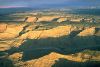
 Surrounded by the canyons of the Paria, Escalante, and Colorado Rivers, the Kaiparowits Plateau is one of the most remote and least visited wild areas in the southwestern United States. Rugged landscape, isolation, and sheer size have made the Kaiparowits a refuge for a remarkable variety of plants and animals. The Plateau features a climax forest of thousand-year-old juniper and pinyon trees, an exceptionally large and diverse population of raptors, spectacular displays of metamorphosed rock created by natural coal fires, and some 300 recorded archeological sites. But the Plateau's most valuable commodities are those most difficult to measure: wind, space, distance, silence, and solitude.
The Kaiparowits Plateau also harbors an estimated 5 to 7 billion tons of recoverable coal. But to amortize the enormous cost of transporting the coal, development on a huge scale would be required, which would destroy the Plateau's wild character.
 The BLM's wilderness recommendation for the Kaiparowits is predicated upon just such a future, for it systematically excludes all lands identified as potential sites for power plants, coal mines, oil exploration, or coal transportation corridors. By contrast, the Utah Wilderness Coalition's proposal would preserve one of the largest remaining blocks of undeveloped public land in the nation.
No Trails, No Guidebooks
From the northern rim of the Kaiparowits Plateau, at evening, the shadow of the Straight Cliffs reaches eastward toward the intricate canyon system of the Escalante River. Directly below is Coyote Gulch, one of the most beautiful -- and popular -- hiking areas in the state. The contrast between the Kaiparowits and Escalante areas is as great as the cliffline separating them. For there are no smooth, well-watered canyon bottoms to follow on the Kaiparowits as there are in the Escalante, nor any published hiking guides. Routes are pencil lines on a topographic map. If the Escalante offers splendid wilderness trips for the novice, the Kaiparowits challenges the most experienced.
| The deer trotted away into the spruce, scarcely showing fear. Small game was abundant. Birds in flocks fluttered by at the approach of the horses . . . . Winding grey aisles of sage led back mysteriously; huge blocks of cliff choked some passages; caverns yawned. Along the outside of the main wall the scattered groups of oak, the lines of spruce, the dots of cedar looked as if they had been planted on the grey grassy level to insure the effect of stateliness, of park-like beauty.
Zane Grey |
Only after seven days of exploration, camped at the brink of a huge amphitheater, did I see the first evidence of 20th-century man. Far away to the south, surrounded by stone monoliths, lay the glittering lights of Glen Canyon Dam.
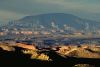
In the annals of southern Utah exploration, the Kaiparowits Plateau is seldom more than a looming presence, always visible at a distance, but seldom actually visited. Clarence Dutton, author of the definitive geological study of the high plateaus of southern Utah, pondered the Kaiparowits from a safe distance of 60 miles away on the crest of Arizona's Kaibab Plateau: "Due northward," he wrote, "rises the great wall of the Kaiparowits Plateau. This giant cliff is 60 miles in length and nearly 2,000 feet high. Throughout its course it wavers but little from a straight line...."
Surrounded by the colorful canyons of the Paria, Escalante, and Colorado Rivers, the vast blue-green wedge of the Kaiparowits, with its wide, level benches, its broad canyons and harsh cliff-lines seems forbidding by contrast. Just reading place names on the map makes one's throat feel dry: Death Ridge...Carcass Canyon...Dry Bench...The Scorpion...The Burning Hills...Last Chance Gulch...Harvey's Fear. The geologist Herbert Gregory wrote in 1931 that "...vegetation in the Kaiparowits region has an unfriendly environment....Many plants have no near neighbors; they stand as individuals in tracts of several acres or are present by twos or threes in areas of several square miles...."
Yet the remoteness, the size, the harsh terrain, the heat, the aridity, the streams poisoned with alkali and arsenic, the wind, the silence when there is not wind, the overpowering solitude of the Kaiparowits -- these are precisely the commodities which make it valuable. It is a fierce and dangerous place, and it is wilderness right down to its burning core.
Life in a Hard Place
The diverse landforms of the Kaiparowits, despite their harshness, host a remarkable variety of plants and animals. From south to north, the land rises 2,000 feet in a series of giant steps. Antelope graze in sage-dotted valleys on the southern perimeter. Grey shale badlands swarm against gold-colored cliff walls. As the valleys twist north into the rising land, they grow deeper and narrower, forming huge, branching canyon systems. Between the canyons lie the great benches of the Kaiparowits, carpeted with an ancient forest of juniper and pinyon pine. Still further north, the land rises to 7,000 feet at the northern rim of the Plateau. Deer, bear, cougar, coyote, bobcat, fox, and badger live in this high country, and its rugged cliffs and canyons are spotted with groves of fir, ponderosa pine, and spruce.The first major environmental impact study of the region -- the BLM's 1975 Kaiparowits Power Project EIS -- noted the variety of species. "The Plateau is unique ecologically because there is a blending of both cold desert and warm desert species," concluded the study. "The harsh, arid terrain supports a surprisingly diverse population of small mammals," it continued, and "...the total number of [bird] species occurring in a year throughout the Kaiparowits area is surprisingly large."
Wildlife studies suggest that as many as 59 species of mammals, 200 species of birds, and 46 species of reptiles and amphibians may inhabit the Kaiparowits (BLM, 1976; 1986). Raptors are especially abundant -- at least 22 varieties of hawks, eagles, and owls can be found on the Plateau. The very remoteness of this country is one of its greatest assets. Raptor populations, for example, "have not suffered the degree of loss common to many other areas," explains the Kaiparowits Project EIS, because "some of the major causes of mortality elsewhere are largely absent in the Kaiparowits area." Likewise, deer are abundant on Fiftymile Mountain, because "the inaccessibility of this high bench provides considerable protection from hunters." For plants, too, the Kaiparowits is a place of last refuge. Of the 841 plant species found on the Plateau, 42 are threatened or endangered, or are candidates for such listing -- nearly half of those listed in Utah.
Culturally, as well as ecologically, the Kaiparowits is richly diverse. Situated at the intersection of three major prehistoric cultures, the Plateau has long been a magnet for archeological study. "From the first year of the Upper Colorado River Basin Archeological Salvage Project," wrote archeologist Elizabeth Lister in 1964, "it has been recognized that the Kaiparowits Plateau might contain important clues that would aid in answering questions in the archeology of the Southwest...." At least 300 archeological sites have been recorded on the plateau, and in recognition of their scientific importance, the BLM has established a protection area called the Fiftymile Mountain Archeological District.
Coal Dreams
In the mid-1970s four of the West's largest utility companies launched a campaign to transform this wilderness into one of the largest industrial complexes in Utah. Their proposal -- the Kaiparowits Power Project -- called for the construction of a 3,000-megawatt power plant on Fourmile Bench, in the heart of the Kaiparowits. Coal for the plant would come from four underground mines in nearby Wesses Cove and on Smoky Mountain.Today, to a visitor strolling among ancient pinyon pines on the proposed power plant site, the environmental impacts of the proposal are difficult to comprehend. Nine thousand acres of vegetation would have been destroyed during construction. A network of roads, power lines, pipelines, pumping stations, and coal slurry lines would have blanketed the western half of the Kaiparowits Plateau. A new road 67 miles long would have cut the Plateau in half, bringing the thunder of heavy truck traffic rolling across the heart of the area. Upper Wahweap Canyon would have become a 300-acre gravel quarry. A new road would have sliced the length of Wesses Canyon, destroying its natural springs and pools. One hundred and twenty million tons of solid waste would have been dumped in a 1,550-acre disposal area on Fourmile and John Henry benches. A new town of 20,000 would have wiped out 4,000 acres of critical antelope habitat on East Clark Bench.
And there would have been the power plant -- a blaze of lights invading the night sky, its 600-foot-high towers belching some 316 tons of pollutants every day into the clear air of southeastern Utah, sending a yellow haze drifting toward Bryce Canyon, Grand Canyon, Glen Canyon, and the Escalante River.
Yes, the Kaiparowits Plateau has coal -- an estimated 15 billion short tons (Doelling and Graham, 1972). Only one half to one third of that coal is recoverable -- perhaps 5 to 7 billion tons, or less than 4 percent of the nation's proven recoverable reserves. But only maximum development could justify the huge costs of construction in this remote region and the cost of transporting the coal to distant markets. The price of Kaiparowits coal would be the destruction of the wilderness character of the Kaiparowits Plateau.
Market Forces Halt Project
In April 1976, with demand for electrical power in southern California falling far short of projections, Southern California Edison abruptly backed out, and the Kaiparowits Power Project fell apart. Environmentalists were blamed for the project's demise. But in the end, economics determined the outcome.The fundamental problem of Kaiparowits coal is the cost of getting it to market. With abundant and more accessible coal available elsewhere in the state and the nation, Kaiparowits coal may never be economic to mine. "...development of the Kaiparowits Plateau coal will face significant economic and environmental problems," explains the BLM in its 1986 Utah wilderness DEIS. "These problems include poor accessibility, lack of abundant water, high costs of underground mining, and competition from nearby areas where coal is more readily available and of better quality...."
But risky economics and appalling environmental hazards alone may not prevent the development of Kaiparowits coal. If the developers cannot bring the power plants to the coal, then they may try to bring the coal to the power plants. In 1979, Union Pacific Railroad unveiled a proposal to build a new railroad across southern Utah and into the heart of the Kaiparowits coal fields. One year later, the U.S. Department of the Interior and the State of Utah conducted a major study of potential railroad and truck haul routes on the Plateau. "Despite delays, an agenda for development at Kaiparowits still exists," explains a study by the U.S. Geological Survey (Sargent, 1984). "Plans....envisage shipment of coal to distant users by truck, conveyors, rail, and (or) slurry line."
The BLM Recommendation -- Driven by Coal
| We stood on the edge of far-as-the-eye-can-see, incredibly beautiful, utterly wild land," Sease recalls, "and I would say, `Gary, why are you eliminating this?' And he'd say, `Because there are no outstanding opportunities for primitive recreation.' And I'd say, `And there's no outstanding opportunities for solitude, either?' And Gary would say, `You're right. You can have solitude here, but it's not outstanding solitude.' And the man kept a straight face while he said that. Had the helicopter left us there . . . we would have known what outstanding solitude was all about. |
According to the BLM, these lands lacked outstanding opportunities for solitude or primitive recreation. The Wahweap roadless area, for example, was cut from the inventory because "although an opportunity for solitude is present, it is judged to be the equivalent of opportunities in other topographies of its kind...." Solitude could not be found on the unit's vast forested benchlands, the BLM concluded, because "the pinyon-juniper forest...does not offer superior visual screening on this terrain...."
In the fall of 1980, Sierra Club representative Debbie Sease toured the Wahweap roadless area with Utah BLM state director Gary Wicks. Their helicopter touched down on the southern tip of Fourmile Bench. "We stood on the edge of far-as-the-eye-can-see, incredibly beautiful, utterly wild land," Sease recalls, "and I would say, `Gary, why are you eliminating this?' And he'd say, `Because there are no outstanding opportunities for primitive recreation.' And I'd say, `And there's no outstanding opportunities for solitude, either?' And Gary would say, `You're right. You can have solitude here, but it's not outstanding solitude.' And the man kept a straight face while he said that. Had the helicopter left us there...we would have known what outstanding solitude was all about."
Usurping the Role of Congress
The real reasons for the BLM's inventory omissions on the Kaiparowits had little to do with solitude. Wilderness study area designation would have been one more roadblock to the development of Kaiparowits coal. Though five BLM inventory team members had recommended WSA (wilderness study area) status for the majority of Kaiparowits wild lands, their recommendations were ignored by managers in the Cedar City district office. In effect, the local BLM managers assumed Congress's role, deciding what ought to be preserved, not just what qualified for preservation. "We tried to make the decision for somebody else, that we had no right to make," recalls one member of the inventory team. "We cut the pie the first time. If Congress never sees the whole pie, then they don't make decisions on it, do they? And that's exactly what happened."The mismanagement of the BLM wilderness inventory on the Kaiparowits led environmentalists to appeal the agency's wilderness inventory decisions before the Interior Board of Land Appeals (IBLA) in 1981. To support their claim that six major roadless units had been overlooked, Utah conservation groups sent a small army of volunteers into the field. After reviewing their work -- more than 200 pages of affidavits and 242 photographs -- the IBLA returned a stunning verdict on the BLM inventory. In the largest reversal of an agency decision in the history of the IBLA, all 300,000 acres of appealed lands on the Kaiparowits were remanded to the BLM for reevaluation. Faced with the prospect of a lawsuit that could lock up the entire Kaiparowits region in litigation for years, the BLM reinstated nearly 80 percent of the appealed roadless areas to WSA status.
In 1986, when the BLM announced its draft wilderness recommendation for those Kaiparowits WSAs, few observers were surprised at the outcome. Of 12 key roadless units on the Kaiparowits Plateau, the BLM could find only two worth designating as wilderness. Virtually all proposed sites for power plants, railroads, coal mines, and coal transportation corridors had been omitted from the agency's wilderness recommendations on the Kaiparowits. Between the BLM's proposed Fiftymile Mountain wilderness unit on the northeast corner of the Plateau, and its proposed Wahweap wilderness unit on the southwest corner, some 450,000 acres of wild land had been zoned for industrial development. And in early 1990, the BLM announced that it would drop the Wahweap unit from its final wilderness recommendation, leaving only Fiftymile Mountain in its proposal.
Abundant Coal -- Scarce Wilderness
The Utah Wilderness Coalition proposal for the Kaiparowits region is based on one simple premise: the land is superb wilderness and deserves to be protected as such. Wild areas as large as the Kaiparowits are extremely rare anywhere in the world. But coal and oil reserves such as those which may exist in the Kaiparowits region are small in comparison with those of other regions of the nation and the world.Our 650,500-acre proposal would protect the sweeping vistas and the important archeological resources of Cave Flat and Fiftymile Bench. It would protect deer, bear, and cougar habitat among the rugged, forested cliffs and canyons along the rim of the Straight Cliffs. It would preserve thousand-year-old pinyon and juniper trees, and thousands of acres of critical winter forage for deer on the high benches at the interior of the Plateau. The Utah Wilderness Coalition proposal would ensure isolation for bighorn sheep in the rugged cliffs west of Glen Canyon, and would preserve critical antelope calving grounds in the valleys and badlands to the south. But most important, the Utah Wilderness Coalition proposal would preserve an opportunity to experience solitude, danger, excitement, and challenge found in few other places on earth.
WAHWEAP-PARADISE CANYON UNIT
Highlights
The largest unit of the Kaiparowits wilderness, this expanse of wild country begins just 10 miles south of the town of Escalante and continues across Paradise Bench to the Wahweap Creek drainage northwest of Lake Powell. Long, winding canyons -- in places narrow and intimate -- dissect the plateau tops, offering both far-ranging vistas and remote hiking. The unit includes an area of ancient juniper trees on Fourmile Bench. The BLM dropped part of the unit (the Death Ridge WSA) in its wilderness study and recommended only 70,000 acres of the remainder (the Wahweap WSA) in 1986. The final recommendation omits the unit entirely. The unit is joined to the Grand Staircase wilderness at The Cockscomb, forming a huge wilderness expanse broken only by the Cottonwood Creek road.Geology and landforms
The steeply dissected topography in the northern part of the unit is dominated by Death Ridge, at 7,956 feet one of the highest points in the Kaiparowits Plateau. Paradise Canyon and Escalante Canyon (a second one) cut through the high benches south of Death Ridge and converge to form Last Chance Creek in the Burning Hills unit. The land forms a staircase down toward the southwest, displaying the Carmel, Entrada, Dakota, Tropic, Straight Cliffs, Wahweap, and Kaiparowits formations. The BLM notes that the Wahweap Formation in the unit contains fossils. The Cockscomb, a prominent serrated ridge, lies at the western boundary.
Vegetation
The benchlands are heavily forested with pinyon pine, juniper, and in higher elevations, ponderosa pine. In the wash bottoms are serviceberry, snowberry, holly-grape, and buffaloberry, growing thick in places. Riparian vegetation grows along Wahweap and Tommy Smith Creeks as well as in Fourmile and Long canyons. The BLM lists Atwood's beardtongue (Penstemon atwoodii) on Death Ridge and in Right Hand Collet Canyon, and Cronquist aster (Xylorhiza cronquistii) in the southeastern part of its Death Ridge WSA; three sensitive plant species including Cymopterus higginsii (Higgin's biscuitroot), Astragalus malacoides (Kaiparowits milkvetch), and Viguiera soliceps (Paria sunflower) inhabit the Wahweap unit, according to the BLM. The Fourmile Bench Old Tree Area harbors a number of 1,400-year-old pinyon and juniper trees which have significant scientific value.Plant communities
The transition from the hot, arid desert floor to the higher plateau country has created diverse habitats within the unit. Mule deer live here throughout the year; the tracks of black bear and mountain lion have been sighted in the northern part; there are even a few antelope on the lower, open benches. The BLM notes that bald eagles and peregrine falcons have been sighted in the unit.Archeology and history
Inventories conducted for proposed coal-mining projects have identified numerous sites used by virtually every prehistoric Indian culture of the region. The sites are mostly suggestive of temporary hunting and gathering use rather than permanent dwellings, according to the BLM.Recreation
Although few people visit the area due to its remoteness and lack of water, interesting hikes are available. Trap Canyon has a short "narrows," unusual in the Kaiparowits. The deeply incised Escalante and Paradise canyons offer a long loop trip; Paradise Canyon has narrow, convoluted sections and the western wall of Escalante Canyon has been likened to the Straight Cliffs. Views from Death Ridge take in the Henry Mountains, the Aquarius Plateau, and the whole of the Kaiparowits region. Wahweap, Tommy Smith, Fourmile Canyon, and Long Canyon have intermittent water. The stunning view of The Cockscomb entertains drivers on the Cottonwood Creek road, and the cliffs and benches rising beyond Lake Powell form a scenic backdrop to the reservoir.BLM recommendation
In 1986, the BLM recommended only 70,380 acres of wilderness for its Wahweap WSA, and dropped the entire WSA from its final recommendation. The BLM dropped Death Ridge from wilderness study in 1980, claiming that the unit lacked outstanding opportunities for solitude. Conservationists appealed to the IBLA, pointing out that the size of the unit, its rough topography and winding canyons, and thick vegetation combined to give excellent solitude. The IBLA told the BLM to look at the unit again, and the agency reinstated it as a WSA. But in 1986, the agencyomitted the unit from its recommendations, citing no specific reason. The agency left out 64,020 acres of the Wahweap WSA from its recommendation, excluding the upper canyons of Wahweap Creek and the northern part of the WSA. The BLM has also set aside an extensive area for pinyon-juniper chaining and sagebrush removal. Conservationists suspect that potential mineral resources underlie the BLM's decision. Exploration or development of these resources would entail high economic and environmental costs due to the remote, arid location; the area may never be suitable for mining regardless of wilderness designation.Coalition proposal
We have identified a total of 228,000 acres that deserve wilderness designation. Our boundary follows narrow, little-used dirt roads, and excludes impacts along the periphery of the unit such as old chainings, seedings, and coal exploration tracks. We include undeveloped lands on Paradise Bench and Ship Mountain Point that connect the BLM's Death Ridge unit with its Wahweap WSA. We also include the Fourmile Bench Old Tree Area, which is absent from the BLM's recommendation. Primitive vehicle ways extend up Death Ridge and into Right Hand Collet Canyon and Escalante Canyon, but for most of their lengths, these ways are primitive, overgrown, and difficult to distinguish from the surrounding countryside. The known solitude and remoteness of this vast wild tract outweigh its speculative mineral values.NIPPLE BENCH UNIT
Highlights
Nipple Bench abuts Glen Canyon National Recreation Area just north and east of Glen Canyon City. The bench offers a scenic view overlooking Lake Powell and the southern Kaiparowits Plateau, and is important habitat for big game. The mesa rim offers good hiking. The BLM dropped the unit in its initial wilderness inventory; we propose 31,600 acres of wilderness.Geology and landforms
The prominent cliffs rising to the north above the Glen Canyon City-Smoky Mountain road (Route 277) are perhaps the most memorable part of this drive. Below the cliffs, isolated rocks sit on top of pedestals of mud and silt amid the badlands north of Lake Powell. Nipple Bench is an intermediate plateau, lying above these badlands and below the higher main plateau of the Kaiparowits. Nipple Canyon, shown on some maps as Lone Rock Canyon, forms the western boundary.Plant communities
The lower badlands are almost devoid of vegetation; desert shrub species such as sagebrush, rabbitbrush, and shadscale grow in the higher areas.Plant communities
The western part of the unit is antelope range (ERT, 1980, p. 3-21). Several springs located on the periphery of the unit are important for wildlife.Archeology and history
Prehistoric site densities are expected to be high (more than 11 sites per square mile) on top of Nipple Bench, according to ERT (1980, p. 3-27). Sites would likely date from the Anasazi period. Studies for the Kaiparowits power project by the Museum of Northern Arizona located significant fossil vertebrates and plants in the north-central part of the unit. The investigators deemed these fossils to be of "major importance" (BLM, 1976, p. A-614). The fossils are in the Cretaceous Wahweap Formation, and include abundant fragments of turtle shells and dinosaurs, as well as several crocodile teeth. There is "an excellent chance that fossil mammals will eventually be discovered" here, the researchers noted.Recreation
Hikes into rugged drainages below cliff walls begin along the road east of Glen Canyon City. The bench area can also be explored from a road leading from the north. This road goes to a scenic viewpoint at the southern cliff edge of Nipple Bench; it is cherrystemmed from our wilderness proposal.BLM recommendation
The BLM claimed that the unit was impacted by mineral exploration, but these activities took place more than 20 years ago and are difficult to see on the ground. Nipple Bench was projected to have a water-supply pipeline and maintenance road as part of the Kaiparowits power plant (BLM, 1976); this may have influenced the agency to drop the unit.Coalition proposal
We support designation of the natural portion of this unit as wilderness. The huge spaciousness of the bench offers heightened experience of solitude. Fewer than 300 acres of the unit are impacted. Our boundary cherrystems an often-used road across Nipple Bench to an overlook to the south. We also exclude about a thousand acres in the north-central part of the unit, where the BLM has been developing a water catchment system for livestock.WARM CREEK UNIT
Highlights
Warm Creek is located in the heart of the Kaiparowits Plateau and is surrounded by the Wahweap-Paradise Canyon, Squaw Canyon, and Nipple Bench wilderness units. Its benches and canyon rims offer views across the southern edge of the plateau into the Glen Canyon National Recreation Area. A coal mine and processing facilities, formerly proposed here as part of the Kaiparowits Power Project, are once again proposed within the unit. Our wilderness proposal would preserve wildlife habitat, archeological resources, and backcountry recreation opportunities from further coal exploration that has thus far proven to be speculative.Geology and landforms
John Henry and Wesses Canyons, which combine to form Warm Creek Canyon, separate the three major benches (Tibbets, John Henry, and Spring Point) that project into the unit from the central Kaiparowits Plateau. The benches, which, at an elevation of 5,000 feet lie below the higher parts of the Kaiparowits Plateau, are formed of the sandstones and mudstones of the Wahweap Formation of Cretaceous age; fossil vertebrates and plants are found in this formation. The canyons are cut into the Cretaceous Straight Cliffs Formation. Although the soils in the unit are fragile and susceptible to erosion, the Warm Creek drainage contributes relatively little sediment to Lake Powell (BLM, 1976, p. II-198). This may be due to the lack of human development in the unit.Plant communities
Pinyon pine and juniper grow on benches, primarily in the northern part of the unit. Springs contribute to perennially moist areas in the upper parts of the main canyons, supporting tamarisk and a few cottonwood trees. The lower slopes are sparsely populated by grasses and shrubs such as shadscale, Mormon tea, fourwing saltbush, and sagebrush.Plant communities
A small population of mule deer use the area, probably wintering in the canyons and moving to the higher benches in summer. The western part of the unit is habitat for antelope, which are commonly found farther to the west.Archeology and history
Studies for coal development projects (BLM, 1976; ERT, 1980) indicate that prehistoric site densities are relatively high in parts of the unit, especially near springs which may have supported ancient agricultural uses. The sites consisted of lithic scatters (stone tool-flaking areas), campsites, and some rockshelters. One study (BLM, 1976, p. II-274) identified 26 sites within a single area proposed for coal mining, and an additional 17 sites adjacent to the mine. These studies, which covered less than 10 percent of the total area that would have been affected by coal mining, revealed over 600 prehistoric and historic sites.Recreation
Warm Creek's location in the middle of the proposed Kaiparowits wilderness area gives it good opportunities for solitude. Views down into the lower benches and badlands leading into the Glen Canyon NRA are especially striking. The grand backdrop of the upper Kaiparowits Plateau is ever present to the north. Access is fairly easy from the dirt road up Smoky Hollow.BLM recommendation
The BLM dropped Warm Creek from its wilderness inventory, claiming that coal exploration and engineering work for the Kaiparowits power project disqualified it for wilderness designation. But the old jeep tracks and drilling sites, located primarily in the northern and western parts of the unit, are slowly returning to a natural appearance after two decades of disuse.Coalition proposal
We propose a 21,000-acre wilderness unit, taking in the undisturbed lands and excluding the primary vehicle ways that receive current use. Coal exploration tracks and scars across the sandy benches, the legacy of poor power-plant planning, should be allowed to fade. Our boundary excludes several primitive roads by cherrystems: one on Tibbet Bench that follows a pipeline from Tibbet Spring three miles to a stock watering reservoir and one on the north (North Branch Creek) four miles to a regularly used stock camp at a spring. The proposed Andalex coal mine would be located in Missing Canyon within the unit, but there is little market for coal from this region and the mine is unlikely to prove economic to operate. A new road is proposed down John Henry Canyon to provide access to the minesite.SQUAW CANYON UNIT

Highlights
The south-central part of the Kaiparowits Plateau has dramatic vistas of isolated rock pillars, barren cliffs, and fluted canyon cliffs. The unit lies west of Burning Hills and east of Warm Creek. The BLM dropped the unit from review in its initial wilderness inventory; we recommend 11,200 acres for wilderness.Geology and landforms
The unit is composed of steep, incised drainages with alternating short benches and cliffs which have carved out the west-facing side of Smoky Mountain. Smoky Hollow drains south along the western boundary of the unit to join Warm Creek. Squaw Canyon lies east of and parallel to Smoky Hollow in the center of the unit. The base of the cliffs in the unit is composed of Tropic Shale; the cliffs and bench tops are Straight Cliffs Formation. Smoky Hollow is the most scenic part of Smoky Mountain and possesses some of the most scenic vistas found in all of the Kaiparowits Plateau.Plant communities and wildlife
Some pinyon and juniper grow on the Smoky Mountain bench in the northeastern part of the unit, with blackbrush and sage predominating across most of the bench. The lower slopes are alkali scrub with barren shale badlands. Little information is available about the unit's wildlife resources; mule deer probably use the benches during the summer and the lower slopes during the winter.Archeology and history
The unit is part of a larger area extensively used by the Kayenta Anasazi and later the Southern Paiute Indians; archeological site densities are expected to be moderate to high, based on studies for coal development in the area (ERT, 1980, fig. 3-6).Recreation
Access is from a well-traveled secondary road leading 15 miles east and north from Glen Canyon City. As this road climbs up the "Kelly Grade" to the top of Smoky Mountain, vistas open out across the cliffs and badlands of the unit. Hikes in Squaw Canyon begin from the Smoky Mountain bench on the north or from a primitive road leading up from Warm Creek on the south. This is rugged country and water is generally unavailable.BLM recommendation
The BLM's initial inventory conclusion and rationale was terse for this area: "The naturalness of the unit has been impaired by extensive coal exploration activity and access roads." The BLM inventory map shows that these impacts are concentrated on the higher, flatter areas; there is a significant natural area in the lower and steeper parts of the unit. The agency probably dropped the unit because a coal haul route for the Kaiparowits power plant had been proposed across it.Coalition proposal
Our field inventory shows that in the canyons themselves, there is almost no evidence of any human activity. The BLM simply failed to change its boundary to exclude only those significant human impacts as its inventory policy required. Coal exploration tracks northeast of the unit are still being used by vehicles and are excluded from our proposal.BURNING HILLS UNIT
Highlights
Located in the core of the Kaiparowits Plateau between the Wahweap-Paradise Canyon and Fiftymile Mountain units, the Burning Hills unit rewards the visitor with treks down intimate, winding canyons and views across a rugged and colorful landscape. A 20-mile-long canyon system offers solitude, with water available in a few places. The unit is named for naturally occurring underground coal fires that have turned exposed hilltops red. The remaining coal seams have led the BLM to withhold a wilderness recommendation for the unit. But as in the rest of the Kaiparowits area, severe economic and environmental constraints render the coal of marginal value compared to the wilderness resource.Geology and landforms
Two north-south ridges, Smoky Mountain on the west and Burning Hills on the east, are divided by a major canyon, Last Chance Creek, and its three large tributaries, Reese's Canyon on the east and Dry Wash and Drip Tank Canyon on the west. Last Chance Creek runs intermittently in its 20-mile course south to Lake Powell. The Burning Hills themselves are a series of pink, round-topped, rugged and steep hills, composed of Cretaceous strata, with many finger-like canyons below. Smoky Mountain has a precipitous, 800-foot-high cliff edge which forms a sheer wall much of the way to the floor of Last Chance Creek.Vegetation
The typical pinyon-juniper forest of the Kaiparowits Plateau blankets the ridgetops in the north and west parts of the unit. In places mountain mahogany grows as tall as 15-20 feet. In the canyons and washes sloping off this plateau are found ancient juniper trees, scrub oak, and single-leaf ash, which turns golden-red in the fall. Rabbitbrush, serviceberry, blackbrush, and buffaloberry form a dense underscoring to the pinyon-juniper woodland. Small riparian areas line the canyon bottoms near springs, such as in Cigar Creek Canyon. The BLM notes the presence of two sensitive plant species: Cymopterus higginsii (Higgins' biscuitroot) on Smoky Mountain and Penstemon atwoodii (Atwood's beardtongue) in the north end of Dry Wash.
Plant communities
Mule deer are common here, and find winter range in the lower, southern exposures which stay clear of snow longer than the high plateau. The BLM lists cougar and various game birds as well, and suggests that some desert bighorn sheep introduced near Lake Powell may have migrated into suitable habitat within the unit. The BLM also notes that the sensitive Lewis's woodpecker and western and mountain bluebird are found in the unit, and that the endangered peregrine falcon and bald eagle found along Lake Powell may also use the unit.Archeology and history
Our field researchers have found lithic scatters (stone chips, flakes, points, and scrapers) throughout the unit, including upper Reese and Last Chance canyons and the Burning Hills proper. Two rock shelters were also found.Recreation
Remoteness, rugged topography, and dense vegetation on the bench tops and in the upper canyons make for outstanding opportunities for solitude. Water is limited, so day hikes and overnight trips starting from nearby roads are most suitable. The lower drainages are wide, deep, winding, and broken by numerous side drainages, with many opportunities for exploration. Hikes are possible down Last Chance Creek from the Smoky Mountain road, down Reese Canyon from near Collet Top, and in various smaller sidecanyons, notably Cigar Creek and Needle Eye. The bench tops are a good place to wander around, and the scorched, nearly barren Burning Hills themselves are a remarkable sight. Few people visit the unit at present.BLM recommendation
After dropping Burning Hills from its wilderness inventory in 1980, the BLM designated a 61,550-acre WSA following formal appeals from Utah conservation groups. The agency recommended against wilderness for the WSA in 1986. No specific reasons were given, but its DEIS notes the presence of nearly 500 million tons of recoverable coal in the WSA. Seventeen pre-FLPMA coal leases cover 13,100 acres in the WSA, according to the BLM. The BLM's minerals consultant pointed out that any coal development here would encounter problems of "poor accessibility, lack of abundant water, high costs of underground mining, and competition from nearby areas where coal is more readily available and of better quality...." (BLM, 1986).Coalition proposal
We propose a 68,400-acre wilderness unit that forms a key part of our Kaiparowits Plateau wilderness. The unit is in a natural condition and offers fine solitude and recreation to the adventurous explorer. Intrusions include a few vehicle ways and oil drill pads around the periphery of the unit, and a few stock improvements, corrals, and an old cabin, all of which are listed by the BLM as "substantially unnoticeable" within its WSA. A mesa on the northern part of the unit, lying outside the WSA, has been partially chained but the remainder is natural and is included in our proposal. The potential for minerals other than coal are rated as unfavorable, and the unit has little promise of significant coal recovery. The outstanding wilderness values of Burning Hills clearly outweigh the limited development potential.FIFTYMILE MOUNTAIN UNIT
Highlights
The scenic culmination of the Straight Cliffs, Fiftymile Mountain offers some of the most spectacular viewpoints on the Kaiparowits Plateau. The unit abuts wild lands in the Glen Canyon National Recreation Area that are recommended for wilderness designation by the National Park Service. Our proposal would preserve the diverse topography and landforms and varied wildlife habitat ranging from the high plateau to the desert environs of Lake Powell.Geology and landforms
Deep canyons, upwarps, monoclines, and hogbacks contribute to the diverse topography of the unit. Included are 42 miles of the spectacular Straight Cliffs, the prominent wall that rises to the west of the Escalante country. Colorful exposures of the Navajo Sandstone are found in Rock Creek and Little Valley.Plant communities
Most of the unit is covered with a pinyon-juniper forest, with the remainder in desert shrub and sagebrush vegetation types. The BLM (1986) notes that some canyons support aspen, maple, and oak, and upper Rogers Canyon supports Atwood's beardtongue, a sensitive species.Wildlife
Fiftymile Mountain exhibits the diversity of wildlife found throughout the Kaiparowits Plateau. According to the BLM, the unit has habitat for as many as 45 species of mammals, 125 species of birds (including 13 species of raptors believed to nest in the unit), 17 species of reptiles, and 3 amphibians. Major game species are mule deer, cougar, and mourning doves. The unit includes some of the best habitat for mule deer on the Plateau. Peregrine falcon and bald eagle nest along Lake Powell to the south and have been sighted within the unit (BLM, 1986, p. 25).Archeology and history
The Fiftymile Mountain Archeological District contains more than 300 sites, including Anasazi habitations and granaries (BLM, 1986).Recreation
Diverse topography makes the Fiftymile Mountain unit conducive to solitude and wilderness activities. The unit is virtually unblemished, without a trace of roads or trails except at its boundaries. Extensive backpack trips through deep canyons and to spectacular vista points can be made here. Access is by jeep roads that form the northern and southern boundaries of the unit, branching off of the Hole-in-the Rock Road just south of Hurricane Wash and near the head of Sooner Gulch. Access from the west is more arduous, following two-wheel-drive and jeep roads leading west of U.S. Highway 89 at Glen Canyon City. Hall (1982) describes the hike to Navajo Point, which is the southeast tip of Fiftymile Mountain in the Glen Canyon NRA. The access trail up the Straight Cliffs is within this unit.BLM recommendation
In 1986, the BLM recommended 92,441 acres for wilderness, but omitted major parts of the roadless area, including the face of the Straight Cliffs, the scenic walls of Collet Canyon, the area known as East of the Navajos, and the west side of Rogers Canyon -- all despite the absence of identified conflicts with wilderness. The agency said these lands had "marginal wilderness quality" -- in spite of the spectacular landforms and great solitude found in the area. The BLM's desire to encourage mineral development may be the real reason; the BLM allowed uranium exploration on the benches of the Straight Cliffs and in Rogers Canyon, consequently dropping much of the Straight Cliffs and Fiftymile Bench. (The mining road into Rogers Canyon has been abandoned and is largely reclaimed.) In several cases the BLM cherrystemmed impassable vehicle ways, such as a route from the Glen Canyon NRA into the southern part of the unit. The final BLM recommendation is expected to omit an additional 1,080 acres.Coalition proposal
We support wilderness designation for 173,900 acres out of an original roadless area of 196,966 acres. Conflicts with wilderness designation are minimal. Oil and gas deposits, if present, are probably too small to recover; small, dispersed deposits of uranium, if they exist, will not be economic to mine in the foreseeable future. The BLM (1986, p. 35-36) considers coal production in the WSA unlikely in the near future because of high production costs and remote markets.FIFTYMILE BENCH AND CAVE POINT UNITS
Highlights
At the foot of the southern Straight Cliffs above the lower Escalante canyons lie BLM wild lands separated from the surrounding vast wilderness only by primitive roads. The Escalante wilderness lies just to the northeast across the Hole-in-the-Rock Road; the drainages of Fortymile Gulch and Willow Creek begin in these units. The Fiftymile Mountain unit of the Kaiparowits wilderness rises to the south and west. Wilderness designation for these units will help to ensure that these essentially unbroken wild regions are not separated by inappropriate development. The BLM dropped both units from its wilderness inventory.Geology and landforms
A thousand-foot-high cliffline of the Summerville, Morrison, and Dakota formations runs the length of these units, separating the Tropic Shale on Fiftymile Bench from the Entrada Sandstone canyons and sandy flats along the Hole-in-the-Rock Road. This cliffline is in turn dwarfed by the rampart of the Straight Cliffs rising above.Plant communities and wildlife
Shadscale, blackbrush, ricegrass, and other species characteristic of these dry cliffs and foothills predominate. Mule deer and small mammals and other animals typical of desert benchlands are found here. The unit is probably an important transition zone for wildlife, containing forage that does not grow on the lower benches, and may serve as winter range for mule deer.Recreation
Hikes along the cliffline reward visitors with grand vistas of the Escalante Canyons and much of southern Utah. The units are the foreground for views from Fiftymile Mountain and a scenic backdrop for the lower Escalante Canyons.BLM recommendation
The BLM claimed that Fiftymile Bench was "heavily intruded from mineral exploration." It offered no description of the kind and location of impacts. Our field checks show that impacts are limited to less than 3 percent of the total Bench area. Those impacts are not significant when compared with the surrounding wilderness area. In Cave Point, the BLM found no outstanding opportunities for solitude or primitive recreation, despite the unit's location at the center of Utah's largest expanse of wild lands, and its proximity to recommended wilderness in the Glen Canyon NRA. Although it acknowledged that "excellent panoramas of the Escalante River drainage and the Henry Mountains are possible from the top of the Fiftymile Bench" and noted the presence of spectacular 100-foot-high pedestal rocks, it classified them as "supplemental values" only.Coalition proposal
Wilderness designation for 11,100 acres in Fiftymile Bench and 4,800 acres in Cave Point is needed to protect the scenic and recreational values of the Kaiparowits and Escalante wild regions. Water developments at Cottonwood Spring and Pole Well are excluded by cherrystems.CARCASS CANYON UNIT
Highlights
The 2,000-foot-high Escalante Rim, the prominent escarpment west of the Hole-in-the-Rock Road, forms the backbone of this unit, located just south of the town of Escalante. Nearly 50 miles of deeply entrenched canyons, some more than 700 feet deep, cut through this northeastern rampart of the Kaiparowits Plateau. The BLM recommended against wilderness despite finding "outstanding" opportunities for solitude and primitive recreation in its 46,711-acre WSA. Our proposal includes the WSA, the adjacent Devils Garden study area, and additional wild lands.