THE SAN RAFAEL SWELL WILDERNESS
- Geology Exposed
- Habitat for Wildlife and Adventurers
- Wilderness Recognized 50 Years Ago
- IPP: The Phantom Power Plant
- Why such an abbreviated proposal?
- Circular Dominoes
- The `Dozers Move In
- The Utah Wilderness Coalition Proposal
- SIDS MOUNTAIN UNIT
- MEXICAN MOUNTAIN UNIT
- SAN RAFAEL REEF UNIT
- WILD HORSE MESA UNIT
- MUDDY CREEK UNIT
- HONDU COUNTRY UNIT
- DEVILS CANYON UNIT
- UPPER MUDDY CREEK UNIT
- CEDAR MOUNTAIN UNIT
- MUSSENTUCHIT BADLANDS UNIT
- RED DESERT UNIT
- LIMESTONE CLIFFS UNIT
- JONES BENCH UNIT
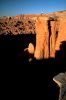
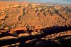
 The San Rafael Swell is a world of jagged cliff faces, narrow slot canyons, and hidden valleys littered with domes and towers. Its landscape is an encyclopedia of earth history, displaying diverse exposed rock formations and erosional forms. It is a popular destination for hikers, climbers, and river runners. But the scenic beauty and historic solitude of the Swell is increasingly threatened by mineral exploration and indiscriminate off-road vehicle use.
Proposals for legislation to protect the San Rafael Swell have been made repeatedly during the past 50 years, culminating with recent proposals for a San Rafael National Park. Yet faced with a clear choice between protection and development, the BLM has zoned for development throughout the interior of the San Rafael Swell, refusing even to study the wilderness character of half a million acres of wild lands.
The Utah Wilderness Coalition's 752,900-acre wilderness proposal would safeguard the region now and complement any additional protections that may be afforded through National Park designation.
Geology Exposed
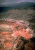
The San Rafael Swell is a microcosm of the entire Colorado Plateau: a huge basin ringed by highlands, studded with mesas and buttes, traversed by powerful, sediment-laden desert streams, and crisscrossed by canyon systems. Because uplift and erosion have been greater in the interior, the oldest rock formations are exposed in the core of the Swell, surrounded by concentric rings of younger rocks which radiate outward like waves in a pond.Each rock formation has created its own unique world. In the heart of the Swell, two perennial streams have bored deeply into the rising land, revealing one of the oldest rock layers exposed in the region -- the 250 million-year-old Coconino Sandstone. So narrow are these canyons, called "The Chute" and "The Black Box," that flood debris hangs from their walls 30 to 50 feet above the canyon floor.
Above the Coconino lies the Kaibab Limestone, a resistant layer which forms the broad floor of Mexican Bend, the hidden valley where the outlaw Butch Cassidy once left two posses eating his dust. Above the Kaibab lie the red beds of the Moenkopi and Chinle formations, forming the intricate, spired redrock mazes of Red Canyon, Penitentiary Canyon, and Keesle Country. Above the Chinle rise the petrified sand dunes of the Wingate, Kayenta, and Navajo formations. Smooth, hard, elegantly sculptured masses of bare rock, these formations form the great outer wall of the San Rafael Reef and the huge, monolithic buttes and towers in the interior of the Swell.
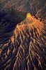
 The rock formations collectively named the San Rafael Group lie for the most part outside the Swell. They include the colorful Entrada Sandstone, which forms the brilliant orange cliffs and towers of Cathedral Valley, Salt Wash, and the Red Desert, and the famous hoodoos of Goblin Valley, just south of the Swell. Higher still lie the psychedelic badlands of the Morrison Formation, an intricate "painted desert" littered with agate, chert, barite, celestite, geodes, gastroliths, dinosaur bones, and glittering shards of gypsum. South and west of the Swell, dark volcanic mountains loom over the badlands, radiating knife-sharp dikes, or fins, of jet-black basalt. And above all this, forming a sea of blue-grey hills to the south and east of the Swell, lies the Mancos Shale, at 65 to 100 million years the youngest rock in the region.
Habitat for Wildlife and Adventurers
This rugged and varied terrain supports an exceptional variety of wildlife. In recent years, the Utah Department of Wildlife Resources (UDWR) has established a population of more than 70 bighorn sheep in the Swell. The UDWR estimates the total carrying capacity of the Sids and Mexican Mountain WSAs alone at nearly 2,000 sheep. More than 300 pronghorn antelope occupy the desert east of the Swell, occasionally venturing into its interior (BLM, 1986). In the jagged cliffs ringing Mexican Mountain, the UDWR has identified more than 11,000 acres of critical peregrine falcon habitat.Not surprisingly, the San Rafael Swell also provides critical habitat for climbers, hikers, and boaters. Just three hours' drive south of Salt Lake City, the Swell is the nearest and most accessible part of southern Utah's canyon country for residents of the Wasatch Front. Its attractions are featured in at least six different guidebooks. Since 1986, Utah publishers have released three new books about the Swell, one of which describes more than 300 miles of hiking routes inside Utah Wilderness Coalition-proposed wild lands. By the turn of the century, according to BLM estimates, non-motorized recreation in the Swell could increase to more than 10 times its current level.
Wilderness Recognized 50 Years Ago
Before 1970, the country surrounding the Swell was one of the most remote regions of the West, a 1.8-million-acre block of rugged and desolate landscape reaching west to the forested ramparts of the Wasatch Plateau, and south into Capitol Reef National Park. But in 1970, with the completion of Interstate 70, access was improved and visitation dramatically increased, bringing a host of new development threats into the heart of the Swell. Mineral exploration accelerated during the late 1970s, and by 1982 off-road vehicle abuse had become a serious problem.Recognizing the danger of such threats, Utahns and conservationists around the nation have repeatedly called for legislation to protect the San Rafael Swell. At least a dozen such proposals have been made in the past 50 years. The first proposal for a new national park in the vicinity came in 1935, when the Utah State Planning Board proposed a 360,000-acre "Wayne Wonderland" national park. In 1936, Wilderness Society founder Bob Marshall identified a roadless area of nearly 2 million acres in the San Rafael Swell -- one of the 10 largest desert roadless areas in the nation. Between 1967 and 1973, a stream of BLM planning documents identified well over 250,000 acres of lands qualifying for primitive or natural area designation, and a 1972 study by Utah State University recommended primitive area designation for 307,000 acres (Dalton and Royer, 1972).
The unique geology of the San Rafael wilderness was again recognized in a 1980 Interior Department study that identified seven potential National Natural Landmark sites within and around the Swell. More recently, the Emery County Development Council has proposed national park designation for 210,000 acres in the northern San Rafael Swell. "While some people may boggle at the idea of another national park in Utah," commented Salt Lake City's Deseret News, "it can be argued that the Emery officials are too modest in their approach."
"The San Rafael country may be the best remaining unprotected desert land," explains Deseret News environmental reporter Joe Bauman, in his book Stone House Lands. "Yet it teeters on the verge of destruction....A new national park, embracing the entire Swell, is the only solution."
IPP: The Phantom Power Plant
| In all, the BLM cut 300,000 acres of wilderness lands from its inventory to clear a power plant site that would never be used. As early as 1977, Interior Secretary Cecil Andrus had gone on record opposing the Salt Wash IPP plant site, and a different site was eventually selected. |
Why such an abbreviated proposal?
In 1979, while the BLM was conducting its wilderness inventory, the agency was embroiled in controversy over the siting of a proposed power plant just south of the Swell. The proposed 3,000-megawatt Intermountain Power Project (IPP), billed as the largest coal-fired power plant on earth, would have radically transformed the entire San Rafael region, bringing a network of railroads, smokestacks, power lines, pipelines, evaporation ponds, and a new town of 9,800 people into the heart of a BLM roadless area lying between the San Rafael Swell and northern Capitol Reef National Park.The BLM was required by law to prohibit new development in roadless lands under study for wilderness. Since the proposed plant site lay in the heart of a 250,000-acre roadless area, wilderness study area (WSA) designation would have delayed or prohibited development of the site. To prevent delay, the Utah state office of the BLM requested and received permission to conduct a special accelerated wilderness inventory in the vicinity of the proposed power plant site. Within 14 months, the agency had eliminated from wilderness study a large region surrounding the plant site and all potential railroad and power line corridors.
In all, the BLM cut 300,000 acres of wilderness lands from its inventory to clear a power plant site that would never be used. As early as 1977, Interior Secretary Cecil Andrus had gone on record opposing the Salt Wash IPP plant site, and a different site was eventually selected. "Andrus made it plain long ago that Salt Wash would never be approved because it's too close to Capitol Reef National Park," complained the Deseret News in January, 1979. "Yet the hasty decisions of the IPP review will stand as BLM recommendations to Congress on important wild lands."
| One of the most spectacular small intrusion complexes in the Colorado Plateau is that in the Little Black Mountain, northeast of Capitol Reef National Park. Here a tremendous array of dikes, sills, and small laccoliths of black basaltic magma have been emplaced in the deep red and brown Triassic and Jurassic rocks along part of the Waterpocket Monocline. This complex is one of the most instructive and one of the most dramatic, easily seen complexes of igneous intrusions anywhere in the world.
Welsh, Hamblin, and Rigby |
Circular Dominoes
Utah BLM officials attempted to justify those recommendations by claiming that in comparison with each other, certain wilderness inventory units were not "outstanding." The agency cut the southwestern sector of the Muddy Creek roadless area from wilderness study, declaring that the spectacular dikes and sills surrounding Little Black Mountain "do not compare with those in the Cedar Mountain area." Just one year later, a National Park Service study identified the Little Black Mountain area as "one of the most instructive and one of the most dramatic, easily seen complexes of igneous intrusions anywhere in the world." Meanwhile, the Cedar Mountain roadless area was also cut from the inventory, after BLM inventory staff concluded that its landscape of colorful badlands, volcanic cliffs and dikes, was "not an outstanding scenic feature when compared with...such areas as...[the] San Rafael Knob." But just nine months later, the San Rafael Knob, too, was cut from the wilderness inventory, when BLM staffers discovered that Ranchers Exploration company had slashed 30 miles of new roads across the highest landmark in the San Rafael Swell.The `Dozers Move In
Cut from the inventory, these lands were now wide open for development of all kinds. Indeed, even while the entire region was under review, the BLM allowed large-scale mining exploration projects to be undertaken inside several key wilderness inventory units. By 1980, uranium exploration companies had constructed at least 40 miles of new roads -- and bored hundreds of drill holes -- in several key parts of the Muddy Creek wilderness inventory unit. Gulf Minerals Corporation, for example, bored dozens of test wells on the rim of Muddy Creek Canyon -- then left the area, violating a signed agreement to reclaim all impacts. The purpose of such actions was obvious. "There appears to be a move to push roads into roadless areas...prior to study or designation," explained BLM area manager Sam Rowley in a memo to the file. Once roaded, an area could never again qualify for wilderness designation.In the absence of wilderness designation, developments such as these may transform the San Rafael Swell from a natural wonder into an industrial mining complex. During the energy crisis of the 1970s, it appeared that tar sand exploration would trigger major new development projects in the heart of the Swell. Two proposals for tar sand development -- both summarily approved by the BLM -- suggest the scope of the damage which may result if tar sand are ever developed in the Swell. To recover an estimated 40 to 60 million barrels of bitumen from the tar sand in the heart of the Swell, Kirkwood Oil Company would drill more than a thousand injection and recovery wells. Underground explosions and fires would cause surface subsidence. A major industrial plant would be constructed, consisting of production and fuel storage tanks, a warehouse, a repair shop, a sewage plant, a network of pipelines connecting the wells, and housing for more than 200 workers. To transport the bitumen to Green River, a fleet of giant oil trucks would make 160 truck trips per day -- one truck every 10 minutes, thundering across the interior of the San Rafael Swell -- "raising safety problems," as the BLM's 1985 environmental assessment put it, "for tourists having to negotiate between large trucks at frequent intervals."
"This traffic," wrote author Joe Bauman in 1987, "plus the workers' off-duty play with ORVs, would wreck whatever solitude remained in the region." All this, to provide enough oil to meet the nation's demand for about four and a half days.
Since the mid-1970s, energy prices have fallen dramatically, and at present neither tar sand nor uranium production is economically feasible in Utah. But an increase in energy prices could bring the developers hurrying back.
Meanwhile, a new challenge to the San Rafael wilderness has arisen: off-road vehicles. Already Buckhorn Wash, the beautiful canyon separating the BLM's Sids Mountain and Mexican Mountain WSAs, has been devastated by off-road vehicle traffic. On a single spring weekend, BLM recreation planners have counted more than a thousand people camped along the Buckhorn Wash road. The entire canyon floor, from wall to wall, is crisscrossed with off-road vehicle tracks. Broken bushes, tree limbs, and beer cans litter the landscape.
The BLM's own planning documents repeatedly emphasize the importance of restricting motorized vehicles throughout the San Rafael Swell to existing roads and trails. In its comprehensive management plan for the San Rafael Swell, published in 1973, the BLM specifically recommended "that all vehicles should be confined to designated roads and trails...to prevent erosion and scarring due to overland vehicular traffic." Moreover, "abandoned roads and trails will be obliterated and revegetated. The fragile soils are highly erosive. Many of the most prominent examples of accelerated soil erosion started in ruts left by vehicles."
Yet the agency's wilderness recommendations systematically exclude huge tracts of land to allow off-road vehicle access. The BLM proposes to throw open some 15,000 acres of lands inside its Mexican Mountain and Sids Mountain WSAs to off-road vehicle use. Within the exclusion areas, the BLM explains, "Present ORV use could continue and expand....No ORV trails...would be closed south of the San Rafael Bridge Campground, on Indian Bench, at Mexican Bend, or to Swasey's Leap." And in the Sids Mountain WSA, the BLM would create 22 miles of motorized vehicle access corridors straight into the center of the proposed wilderness, literally cutting it in half. The principal objective of BLM's wilderness proposal for the area, explains the DEIS narrative, "is to...avoid conflicts with traditional ORV access routes."
The Utah Wilderness Coalition Proposal
"Something more important than the thrill of blasting across slickrock on a hot bike is at stake here," wrote Joe Bauman in 1986, in a plea for legislation to protect the San Rafael Swell. "Wild nature is priceless and irreplaceable."We agree. The Utah Wilderness Coalition proposal will protect all of the San Rafael Swell's natural wonders. Each of the 14 units included within our proposed San Rafael Wilderness offers superb wilderness values -- yet too few of them have been recognized by the BLM as candidates for wilderness designation. By extending wilderness protection to all deserving lands in the San Rafael Swell, we can yet preserve one of the nation's most important natural wonders.
SIDS MOUNTAIN UNIT
Highlights
For most Utahns, this is the slickrock wilderness closest to home: the northern overlooks and trailheads of Sids Mountain are less than three-and-one-half hours' driving time from Salt Lake City. Part of the oft-proposed San Rafael National Park, sandstone-walled canyons wind northward from the Head of Sinbad at the center of the Swell to the Little Grand Canyon of the San Rafael River. Those who seek to float a wilderness river or to explore hidden mesas and canyons will not be disappointed -- despite tragic overgrazing near streams and springs and an increasing off-road vehicle threat. The BLM recommends 80,000 acres for designation, but divided the unit with off-road vehicle corridors in canyon bottoms. The Utah Wilderness Coalition's 95,800-acre proposal would protect habitat for desert bighorn sheep and hikers by including these canyon bottoms. It would also add to the diversity of the unit by including colorful badlands at North Salt Wash on the northwest and bighorn sheep habitat at Cane Wash on the east.
Geology and landforms
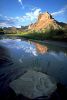
Sids Mountain proper is actually a broad mesa, the highest among several that cover the unit. Knobs and buttes of Navajo Sandstone dot the uplands -- some with unusual names given by pioneer stockherders. The mesas drop off into deep canyons with sheer Wingate Sandstone cliffs. A candidate for wild and scenic river designation, 16 miles of the San Rafael River flow through the northern part, forming the spectacular gorge deservedly called the Little Grand Canyon.Plant communities
Scattered pinyon pine and juniper are found across the mesa tops, interspersed with grassy areas. The slopes below these mesas chiefly support shrubs such as blackbrush, sagebrush and rabbitbrush. Willow and tamarisk line the San Rafael River; these and other riparian species also occur along the trickling perennial flows of North Salt Wash and Virgin Spring Canyon. Relict plant communities occur on Pinnacle and Bottleneck Peaks and provide baseline data for scientific study. The BLM notes that the unit includes habitat for a dozen rare plant species including cacti and milkvetches.Wildlife
Sids Mountain provides crucial yearlong habitat for desert bighorn sheep, according to the BLM. The sheep were reintroduced in 1978 and 1979 and have more than doubled in population since that time to number about 60 at present (BLM, 1986, p. 18). Mule deer browse in the unit and attract occasional mountain lions. Raptors inhabit the unit yearround and golden eagles are especially prevalent. Bald eagles have been sighted west of the campground along the San Rafael River, the BLM notes. Waterfowl use the river as a refueling area during migration, and the UDWR has listed the entire unit as a peregrine use area.Archeology and history
A superb Fremont Indian pictograph panel can be found just off the San Rafael River. The BLM also notes other remains of the Fremont culture, including a petroglyph and a granary. A historic cabin has recently been acquired in the north of the unit and an old mine of historical interest is located in its center.Recreation
The 18-mile float trip down the San Rafael River from Fuller Bottom to the Buckhorn Wash bridge is particularly impressive, yet can be done in small rafts, kayaks, canoes, and even innertubes (see Nichols, 1986). Hikers also follow the river during low water, crossing its course many times. The San Rafael's twisting and colorful canyons and sheer sandstone walls have earned it a nomination for National Wild and Scenic Rivers designation. Away from the river, hiking and horseback riding afford spectacular panoramic vistas from the parklands above the canyon system (see Kelsey, 1986b). For those who prefer to stay near their car, the Wedge Overlook at the northern edge of the unit affords breathtaking views of the Little Grand Canyon and the Coal Wash Overlook on Interstate 70 looks out over the South Fork of Coal Wash and the Block Mesas. Because of its proximity to the Wasatch Front, Sids Mountain is expected to receive a dramatic increase in recreational use beyond its 1,000 visitor days per year as recorded by the BLM.BLM recommendation
The BLM initially recommended wilderness for 78,408 acres of its 80,530-acre WSA, and is expected to recommend 80,084 acres in 1990. The agency excluded lands in upper Cane Wash and North Salt Wash from study by drawing straight line and topographic boundaries, contrary to its inventory policy. The North and South Forks of Coal Wash, Bullock Draw, and Saddle Horse Canyon were deleted from the 1986 draft recommendation to open up 25 miles of ORV corridors into the heart of the unit. ORV use would shatter the silence, damage vegetation, and disturb wildlife habitat in these wash bottoms. Mineral conflicts within the unit are insignificant, according to the BLM.Coalition proposal
The Coalition proposes wilderness designation for 95,800 acres. Important for its spectacular maze of canyons, educational geology, numerous endangered and threatened plants, and bighorn sheep population, the entire Sids Mountain unit deserves protection. Off-road vehicle corridors contradict the definition of wilderness and have no place in the heart of the unit. Closure of these routes at the canyon rim, not at the wash bottom, is the only manageable wilderness boundary. We also include undisturbed lands north of the San Rafael River and west of the Wedge Overlook, but omit the roaded overlook itself.MEXICAN MOUNTAIN UNIT
Highlights
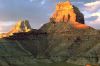
Geologic wonders typify this unit: the northern reaches of the San Rafael Reef, the mysterious slot canyons of the Upper and Lower Black Boxes, a cliffline north of the river reminiscent of Capitol Reef National Park, Mexican Mountain itself, and countless canyons cutting across the northeast side of the Swell. The most unusual geologic feature in the unit is excluded, however, from the BLM's 46,750-acre recommendation: Windowblind Peak, one of the largest free-standing monoliths in the world. The 102,600-acre Coalition proposal includes Windowblind Peak and other lands at the west end of the unit. These lands are an important link to the Sids Mountain unit (across the Buckhorn Wash road) for the northern San Rafael desert bighorn sheep herd and are critical habitat for the endangered peregrine falcon. They are also an important part of the view from the Wedge Overlook and should be kept free from further off-road vehicle damage and development.Geology and landforms
The unit displays a vertical mile of uplifted strata on the east flank of the San Rafael Swell, including deposits from the Pennsylvanian to the early Cretaceous. The Navajo Sandstone covers about one-fourth of the unit, chiefly in the northeast and east, where it is carved into colorful buttes surrounding Cottonwood and Spring canyons. Wingate Sandstone cliffs line the north side of the river for 20 miles below the bridge at Buckhorn Draw. Here the river enters the Upper Black Box, a forbidding slot canyon carved into dark Paleozoic rocks. The spectacular Mexican Bend, where the San Rafael River curves around the massive bulk of Mexican Mountain, can be viewed at the crest of the Horsethief Trail. The river exits the San Rafael Reef just north of Interstate 70 through the Lower Black Box. Windowblind Peak, a 1,200-foot-high tower located south of the San Rafael River at Buckhorn Wash, is visible from many vantage points throughout the Swell. Its name comes from its ability to block the sun in an otherwise open landscape.Plant communities
The unit is composed primarily of pinyon-juniper forest on the uplands, shrubs and grasses at lower elevations, and riparian plants along streams and washes. Two endangered and six proposed or candidate plant species may grow in the unit.Wildlife
According to the BLM, the unit encompasses more than one-fourth of the range for the North San Rafael desert bighorn herd and supports a few mule deer as well. Mountain lions hunt within the unit. The BLM has identified 11,290 acres of critical habitat for the endangered peregrine falcon in its WSA, along with a number of falcon and golden eagle nests. The endangered bald eagle has been sighted during its migration.Archeology and history
Five archeological sites have been recorded but a thorough inventory has not been made, according to the BLM. The Old Spanish Trail, a mid 19th-century route from New Mexico to California, runs just north of the unit and a remnant may be within the WSA. Swasey's Leap, site of Sid Swasey's legendary horse jump across the Lower Black Box, is a favorite destination. Along Mexican Bend are remnants of an old corral and camp where the western outlaws, the Wild Bunch, frequently stayed. The abandoned Smith cabin and corrals on the eastern boundary record early use by livestock herders. An impressive pictograph panel is found along Black Dragon Canyon, but easy access by vehicles has led to some defacement of the panel.Recreation
The Mexican Mountain unit offers countless recreational opportunities. Good access is available by a spur road which follows the San Rafael River for 15 miles below the bridge at Buckhorn Wash. This road provides access to the upper Black Box and Spring Canyon, both excellent hikes. Cottonwood Canyon, the historic Horsethief Trail, and the Lower Black Box are reached by good dirt roads branching off of Highway 6 or Interstate 70. The San Rafael River, under consideration for Wild and Scenic status, provides challenging kayaking and tubing during the spring runoff and into the summer. The unit's hiking is detailed in Hall (1982) and Kelsey (1986b); the float trip down the Black Box is described in Nichols (1986). Horse riding, rock climbing, fishing, hunting, rockhounding, and (occasionally) ski touring are available as well.BLM recommendation
The BLM recommends wilderness for only 46,750 acres of its 59,600-acre WSA, omitting part of the western portion of the WSA and creating a broad vehicle corridor north of the San Rafael River all the way to Mexican Mountain -- the very heart of the WSA. It also allows a cherrystem road to Swasey's Leap. The WSA itself excludes large areas on the north and south because of a claimed lack of naturalness. Uranium and tar sand deposits may have motivated the exclusions, even though mining is generally infeasible.Coalition proposal
The Coalition proposes 102,600 acres of wilderness. The imposing geologic formations, important wildlife habitat, rich history and outstanding recreational opportunities of the unit need to be preserved for generations to come. Conflicts with wilderness designation are few. Some ORV use occurs around the San Rafael River campground and the spur road down the river, but nearby roads and trails along the Buckhorn Wash road would remain open to such use. Uranium and tar sand are found in the unit but their economic potential is low (see overview). Human intrusions are substantially unnoticeable in this huge landscape. Our boundary cherrystems the road along the San Rafael River (instead of deleting a broad swath five miles long as the BLM recommended), but includes old mining impacts (including bulldozer trails and an abandoned landing strip) at Mexican Bend as does the BLM. Our boundary includes Black Dragon Canyon to just below the well-known pictograph panel in order to protect the panel from further damage.SAN RAFAEL REEF UNIT
Highlights
The San Rafael Reef, the steeply tilted slickrock cliffs forming the eastern edge of the San Rafael Swell, displays some of the most spectacular and educational geology in the country. Its hidden canyons and open benchlands offer excellent recreational opportunities, significant historical and archeological sites, and habitat for endangered plants as well as for golden eagles and desert bighorn sheep. A total of 95,000 acres should be protected, connecting the Mexican Mountain and Muddy Creek units to protect the entire length of the Reef.Geology and landforms
The San Rafael Reef, a classic plunging anticline breached by numerous short canyons, rises abruptly from the desert west of the town of Green River and northwest of Hanksville. The unit displays fascinating rock formations including arches, caves, knobs, pinnacles, sheer cliffs, and water-filled potholes. Grape agate, a rare gem found in only a few areas of the country, is present in the unit, according to the BLM. Soils in half of the BLM's WSA would be highly erodible if disturbed (BLM, 1986, p. 9) and thus would limit development. Straight Wash cuts to the Pennsylvanian Hermosa Group, the oldest formation in the San Rafael Swell, and there are large exposures of Coconino Sandstone with narrow slot canyons.Plant communities
Most of the unit is sparsely covered with a pinyon-juniper forest and associated desert shrubs. The remainder consists of grassland, shrub growth, and barren land. Eight rare plant species have been identified in the WSA (BLM, 1986, p. 10).Wildlife
The BLM designated 27,311 acres of its WSA as high-priority desert bighorn habitat. Most of the South San Rafael desert bighorn sheep herd lives in the unit, which includes critical rutting and lambing grounds. Other mammals present, according to the BLM, include mule deer, coyotes, bobcats, cottontail rabbits, badgers, Ord kangaroo rats, gray foxes, kit foxes, and white-tailed antelope squirrels. The golden eagle, a sensitive species, inhabits the unit.Archeology and history
Ancient Indian rock art can be found in several locations. Six sites have been recorded in the WSA, according to the BLM, which notes that additional undiscovered sites are likely to occur. Remnants of historic wagon trails can also be found.Recreation
The proximity of the San Rafael Reef to Utah Highway 24 and Interstate 70 makes for easily accessible recreation. Backpacking, rockhounding, hiking, camping, rock scrambling, photography, and scenic viewing are all excellent in this area. The rugged topography permits the visitor to experience a high degree of solitude and challenge just a few miles from the paved highways. Hiking trips in the unit are described in Kelsey, (1986b) and in Joe Bauman's Stone House Lands (1987).BLM recommendation
In its initial inventory, the BLM reduced the size of the unit from 101,270 acres to 63,264 acres, claiming it was retaining only the "areas of principal interest." As a result, its boundary crosses large natural areas averaging six miles from the original boundary road. The BLM then deleted 17,000 acres by exaggerating the extent of a few small intrusions, many of which show no evidence of construction and are almost completely reclaimed. In 1986, the BLM expanded its diminutive WSA from 55,540 acres to 59,170 acres and recommended wilderness for the entire area. The intrusions that the BLM used to justify its inventory deletions have but a minor effect on the unit's overall naturalness and solitude. For example, the BLM used two dirt jeep trails to drop over 3,000 acres of steep canyons just south of Interstate 70. The trails are less than 7 feet wide and total 5.5 miles in length; they occupy a total area of fewer than 6 acres. They are largely reclaimed since the construction of Interstate 70 which fenced them off and rendered them unusable to vehicles. The BLM deleted about 4,000 acres north of Temple Mountain, claiming that impacts separated this strip of land from the larger roadless area. But the impacts total fewer than 5 acres along a 4.5-mile-long reclaimed jeep trail. A section of state land was dropped for similar reasons.Coalition proposal
The BLM states that its 55,540-acre WSA provides outstanding opportunities for solitude and important wildlife habitat. We agree, but the same applies to additional roadless lands west of the WSA and on benchlands beneath the Reef. The wilderness unit should be expanded to take in these lands. Habitat and recreational opportunities should be protected not just within the deep sandstone canyons, but also in the access gullies, the benches, and pinyon-juniper forest. All of these features work together to protect the character of the land and its inhabitants. Our 95,000-acre San Rafael Reef unit deserves wilderness status in order to preserve its crucial desert bighorn sheep habitat, its unique geology, and its outstanding solitude and primitive recreation values.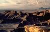
WILD HORSE MESA UNIT
Highlights
In the badlands between the San Rafael Reef and Capitol Reef National Park simple forms and solid colors combine in a landscape of barren purity. Highly susceptible to erosion when disturbed, these badlands should be off limits to vehicle use to protect scenery and downstream water quality. Wild Horse Mesa is adjacent to Goblin Valley State Park on the northeast and is separated from the Muddy Creek unit on the north and west by only a primitive road. Muddy Creek runs for about 30 miles through the unit. Unlike any area the BLM has recommended, this unit and the Muddy Creek unit include the full range of Jurassic and Cretaceous badland formations from the Carmel through the Morrison to the Mancos. Unfortunately, the BLM relied upon an obsolete power plant siting study to exclude Wild Horse Mesa from wilderness study. The Coalition proposes 57,400 acres for designation.
Geology and landforms
Smooth, wide-open badlands, crisscrossed by occasional deep canyons create a moon-like, otherworldly atmosphere. Jet-black stone pinnacles and "goblin" formations (like those in adjacent Goblin Valley State Park) add to the effect. The cliffs of the San Rafael Reef in the Muddy Creek unit rise to the north. The oldest formations (Carmel, about 180 million years old) are along the north and east sides of the unit, and the youngest (Mancos Shale -- about 80 million years old) are on the south and west. (See Mussentuchit Badlands unit for discussion of sensitive soils which cover most of this unit.)Plant communities
Much of the unit is barren, but greasewood is dominant along Muddy Creek and shadscale with galleta grass is found on the uplands. The endangered fishhook cactus Sclerocactus wrightiae may be present, according to the U.S. Fish and Wildlife Service. Riparian habitat is found along Muddy Creek.Wildlife
The northern part of the unit is yearlong bighorn sheep habitat (BLM, 1988b, vol. 2, p. 71).Recreation
During high water in the spring one can float the entire length of Muddy Creek to Hanksville, viewing the constantly changing colors and varied topography of the area. (See Upper Muddy Creek unit for further information.) Hiking, sightseeing, and photography opportunities are outstanding in the unit's cliffs and badlands.BLM recommendation
The BLM rejected the entire inventory unit during a special accelerated study conducted in 1979 to make way for the proposed Intermountain Power Project. That power plant was subsequently located near Delta on the other side of the state, but the inventory decision was never revised (see area overview). According to the BLM, the unit was dropped because of the "extensive human activities" found in about one-third of the unit. These consisted of about 18 miles of vehicle ways, an area of contour furrows (1,000 acres), four stock reservoirs, and three miles of seismograph lines. These impacts are concentrated in the western part of the unit; most are near its edge. The entire eastern and southwestern portions of Wild Horse Mesa, on the other hand, were deemed "essentially natural" by the BLM. Still, despite the clearly limited extent of human impacts on the majority of the unit, the total area was determined to be lacking in basic wilderness attributes. The agency excluded the great wild badlands south and west of the Reef (including Wild Horse Mesa) from any conflict with the proposed Intermountain Power Project by concluding that only slickrock areas could be wilderness.Coalition proposal
Our proposed 57,400-acre wilderness unit excludes the significant "human activities" that the BLM cited in dropping the unit from wilderness study. For example, the 1,000 acres of contour furrows, as well as an area of mining impacts, are both isolated at the extreme north boundary of the roadless area and are excluded by minor boundary adjustments. Further, the vehicle ways described by the BLM are 25 years old and have grown over or simply disappeared due to erosion, making them practically invisible to anyone on the ground. They do not represent an impact so severe that Wild Horse Mesa should be denied wilderness status.
MUDDY CREEK UNIT
Highlights
Reaching from the interior of the San Rafael Swell to the northeast corner of Capitol Reef National Park, Muddy Creek is the second largest block of undeveloped BLM land in Utah. Within this huge area every landform found in the San Rafael region is represented: 200 million years of geologic history from the Permian Coconino Sandstone to Tertiary igneous intrusions folded and carved into towering mesas, sweeping badlands, impassable reefs, slickrock domes and canyons, and random black walls. The BLM's 56,735-acre proposal includes only the San Rafael Reef (Crack Canyon WSA) and the upper Muddy Creek Gorge (Muddy Creek WSA) while excluding most of the unit's many outstanding geologic features: Factory Butte and Little Black Mountain, lower Muddy Creek Gorge, Segers Hole, the Moroni Slopes, Sinbad Country, North Caineville Mesa and Reef, Hebes Mountain, and Salt Wash. The 246,300-acre Coalition proposal would protect the full scientific, ecologic, watershed, scenic, and recreational values of this incomparable landscape.
Geology and landforms
The center of this unit at the junction of lower Muddy Creek Gorge and Segers Hole is the southwestern tip of the oval-shaped San Rafael Swell uplift. From this point, great Wingate and Navajo sandstone cliffs run north along Muddy Creek and east along the San Rafael Reef defining the southern and western limits of the Swell. Inside these cliffs to the east and north is the Sinbad Country. Here Muddy Creek's tributaries have cut myriad small, twisting canyons through the reddish-brown Moenkopi Formation. Muddy Creek cut deeper into the gray Kaibab Limestone with spectacular inner gorges in the slickrock Coconino Sandstone. Outside the Wingate and Navajo cliffs, upper Mesozoic badlands interrupted by small igneous intrusions extend south to the Fremont River and west to Cathedral Valley in Capitol Reef National Park (see Wild Horse Mesa and Cedar Mountain units).Plant communities
Rock outcrops and barren land predominate, with sparse desert shrubs and grasses (principally shadscale and galleta) across much of the unit. A low-growing pinyon-juniper forest covers the Sinbad Country. Scattered pinyon and juniper trees are also found in the Reef and on higher rims west of Muddy Creek. Cottonwoods occur in small groves along many canyon and wash bottoms. Five candidate, one proposed, and two listed threatened or endangered plant species are known within or near the unit, according to the BLM. Hebes Mountain has a 650-acre relict plant community. Because no water occurs on the mountain, it is not likely that grazing has ever taken place here. Tall grasses such as ricegrass and galleta, as well as shadscale and juniper, grow here.Wildlife
The UDWR and BLM have identified the higher parts of this unit in the Crack Canyon WSA as "high-priority desert bighorn sheep habitat" with "habitat for about 32 percent of the desert bighorn sheep in the south San Rafael herd" (BLM, 1986, p. 14-15). The UDWR identified the northeastern part of the unit (the Moroni Slopes) as critical yearlong habitat for desert bighorn sheep. Mule deer, wild horses, gray fox, kit fox, and smaller mammals inhabit the unit. Raptors include bald and golden eagles, ferruginous hawks, and rough-legged hawks.Archeology and history
Several archeological sites including rock art and a structure are known, but the full extent of cultural resources is unknown.Recreation
The rugged terrain offers unforgettable opportunities for solitude and primitive recreation. Activities include hiking, backpacking, sightseeing, photography, geologic study, and horseback riding. (See Upper Muddy Creek unit for description of float trips down Muddy Creek.)BLM recommendation
The agency recommends only 56,735 acres in its two WSAs (Crack Canyon and Muddy Creek) for designation. Instead of recognizing the national and international significance of this wilderness resource, the BLM concluded in its 1979 inventory that about 152,000 acres, including the area surrounding the proposed Salt Wash site of the Intermountain Power Project (IPP), lacked wilderness character. Another 36,000 acres were excluded in the 1980 intensive inventory decision. The areas deleted are described in detail below. The first six were part of the Muddy Creek/Moroni Slopes special inventory unit that was released in 1979, and the last two were part of the Crack Canyon, Chute Canyon, and Cistern Canyon intensive inventory units that were released in 1980.(1) Muddy Creek Gorge (1,000 acres) -- Below the southern boundary of the BLM's Muddy Creek WSA, the stream enters the deepest canyon along its entire course where it cuts through the southern rim of the San Rafael Swell, winding between colorful, thousand-foot-high sandstone walls. During the wilderness inventory the BLM identified a "road" running up the bed of this canyon. On the east side of the canyon, the BLM recommends wilderness designation for its Crack Canyon WSA. Yet during the hasty accelerated inventory, the BLM cut the west side of the canyon, asserting that it lacked wilderness character. While visible in several places for short distances, the old jeep trail is neither a road nor a significant human impact. Indeed, for most of the canyon's length, the track either runs down the bed of the stream or, where located above the streambank, has been completely obliterated by erosion or so thoroughly revegetated that it is difficult to locate or recognize. The Crack Canyon WSA should have included this insignificant impact and been extended west and south to include the lands described below.
(2) Segers Hole (7,000 acres) -- Segers Hole is a 3,000-acre basin, bounded by Navajo slickrock walls, which drains through a deep, narrow slot canyon into lower Muddy Creek Gorge. Rugged slickrock fractured by the folding of the San Rafael Reef and Moroni Slopes extends north and south of the slot canyon. The BLM released Segers Hole in its 1979 inventory decision, citing mineral exploration impacts dating from 1974. The way which was used for access to Segers Hole is now badly eroded and probably will soon be completely impassable. It should be closed to protect scenic and wilderness values. The BLM has proposed a 7,120-acre ACEC "to protect the scenic values from irreparable damage that could occur from possible mineral exploration or ORV use" (BLM, 1988b, vol. 2, p. 97). However, the agency's proposal would not prohibit mineral entry or leasing or close the old ways to ORV use.
| "[The Little Black Mountain] area is becoming increasingly trafficked by tourists because of the improved road connection between Interstate 70, through Last Chance Canyon, and the Cathedral Basin area of the northern part of Capitol Reef National Park. In addition light grazing is having some moderate effect, but even more severe is the danger of extensive off-road vehicle damage in the softer rock units."
Welsh, Hamblin, and Rigby |
(4) Hebes Mountain and East Cedar Mountain (16,000 acres) -- These brooding basalt-capped mountains loom above the rim of the Muddy Creek canyon system in the northwest portion of the unit. They contain striking displays of volcanic intrusions, including radiating systems of "dikes" -- thin blades of dark volcanic rock that cut over the land like the Great Wall of China.
(5) Cat Canyon and the Dike (15,000 acres) -- Cat Canyon: An extremely rugged and beautiful canyon bordering the unit on the north. The Dike is a steeply sloping plateau rising to an abrupt cliffline on the north side of the unit, offering spectacular views of the interior of the San Rafael Swell, Tomsich Butte, and Muddy Creek Canyon. The BLM (1979) noted that "Around Cat Canyon (both to the north and south) there are 13 miles of ways and one long seismograph line (four miles), but they are not obvious in the finely dissected tablelands."
(6) Keesle Country (12,000 acres) -- Wildly shaped and colored terrain, yet more than half (including a portion of Muddy Creek itself near the mouth of Penitentiary Canyon) is omitted from the BLM's Muddy Creek WSA.
(7) Cistern and Chute canyons (33,000 acres) -- These lands north of the Crack Canyon WSA were excluded from the WSA in violation of inventory policy. The BLM properly cherrystemmed a regularly used and maintained road from near Temple Mountain to Chute Canyon five miles to the southwest. However, it improperly excluded a vehicle way extending from the end of the maintained road at Chute Canyon west to Muddy Creek, forming the north boundary of the WSA. A vehicle way does exist but at the time of the wilderness inventory no grading had occurred in many years. Perennial shrubs (ephedra and shadscale) as well as grasses could be found in both the center and wheel paths of the route. At the mouth of an unnamed canyon west of Bell Canyon, the way was so badly eroded that all passage by standard highway vehicles ends. (The boundary between Chute and Crack canyons also follows a similar jeep trail that also does not qualify as a road.) The BLM claimed that the lands north of the way were natural but released them from study saying that they lacked outstanding opportunities for solitude or primitive recreation.
(8) Wild Horse Creek (3,000 acres) -- These lands are along the southeast boundary of the Crack Canyon WSA. They are natural and should have been included in the WSA.
Coalition proposal
We recommend wilderness protection for 246,300 acres surrounding Muddy Creek, incorporating all of the major features of the unit, from Cat Canyon on the north to North Caineville Mesa on the south, while excluding all significant human impacts around the perimeter of this roadless area through boundary adjustments. The Coalition also urges the BLM to aggressively pursue a land exchange with the State of Utah to acquire state-owned sections T. 25 S., R. 8 E., #2 and T. 26 S., R. 9 E. #16 -- both of which lie along the path of Muddy Creek in the heart of the unit.HONDU COUNTRY UNIT
Highlights
Hondu Country is a six-mile square of canyons and ridges without names. Little known and seldom visited, it provides habitat for a growing herd of desert bighorn sheep and range for a small band of wild horses. This unit is broken by ridges and canyons up to 400 feet deep. The BLM found Hondu Country to be roadless and natural, but refused to designate a study area. The Coalition recommends an 18,900-acre wilderness unit to protect this eminently wild area which complements the scenic and wildlife values of the Muddy Creek unit to the west and south.Geology and landforms
The Moenkopi Formation outcrops which cover most of the unit are deep red and often lie in rippled layers reminiscent of the mudflats and tidelands in which they were formed. The uplands are broken with ridges and ravines. The four major drainages are between 300 and 400 feet deep, twisting their way through canyons at two miles to every mile in a straight line. They cut through the Kaibab Limestone into the slickrock Coconino Sandstone.Plant communities
Pinyon-juniper woodlands are scattered throughout the unit. Sage and annual grasses characterize the plateau on the east. The proposed endangered San Rafael cactus, Pediocactus despainii, may also exist in this unit.Wildlife
A wild horse herd inhabits the unit, and the UDWR classifies it as yearlong bighorn habitat.Recreation
Hondu Country offers many challenging hikes. Campers can easily find solitude and isolation within the rippled redrock.BLM recommendation
In its intensive inventory the BLM dropped the Hondu Country unit, claiming it lacked outstanding solitude and recreational values even while acknowledging the lack of human intrusion. The quality and diversity of recreational opportunities is at odds with BLM claims. The BLM claimed the configuration of the unit limited solitude due to three state inholdings. The state inholdings neither limit solitude nor were considered legitimate obstacles to wilderness designation by the IBLA. These inholdings are land of the same basic character as the federal land. The BLM also inappropriately equated screening with solitude. Clearly the broken nature of the land provides solitude.Coalition proposal
The Coalition proposes an 18,900-acre Hondu Country wilderness unit to protect challenging recreation opportunities in a remote, little known setting as well as habitat for desert bighorn sheep.DEVILS CANYON UNIT
Highlights
Devils Canyon begins in the heart of the San Rafael Swell just south of Interstate 70 and flows west into the broad valley of Salt Wash. The Coalition's 21,500-acre proposed wilderness would protect a rugged, colorful landscape that is nonetheless easily accessible for primitive recreation and scenic overlooks. Cutting deep into ancient layers of rock, the cliffs and narrow canyons in this unit offer a splendid view into the past. The unit also has important habitat for golden eagles and contains a number of endangered plant species.Geology and landforms
Devils Canyon slices 1,000 feet into the crest of the Swell, providing spectacular views from overlooks on the south side of Interstate 70. Here, erosive forces have exposed layers of ancient rock formations (chiefly the Glen Canyon Group) in the narrow, twisting canyon. Away from the canyon, benches, knobs, mesas, and colorful badlands give character to the land.Plant communities
Despite its relatively small size, this unit is a treasure trove of endangered and threatened flora. The BLM (1986, p. 8) notes that its WSA may harbor two species currently listed as endangered, one proposed endangered species, as well as five candidate species. The dominant vegetation type in this unit is pinyon-juniper in the higher parts of the unit, with desert shrubs in the lower parts.Wildlife
Along with bats, bobcats, badgers, coyotes, kit and grey foxes and black-tail jack rabbits, there is a wide variety of rodents, and an equally wide variety of raptors to consume them. The latter include golden eagles, ferruginous hawks, prairie falcons, American kestrels, and red-tailed and rough-legged hawks. Mountain lions and mule deer include this area in their winter range. Of particular interest is a small wild horse herd on the natural benches.Archeology and history
The unit contains one recorded pictograph site, according to the BLM. Many others may exist; however, no cultural inventory has yet been made of the area.Recreation
The deep, winding canyon and its tributaries can be explored and enjoyed in solitude. The 10-mile-long canyon bottom, with its short but impressive narrows, is a superb hike. The benchlands provide ample space and terrain for those who really want to stretch their legs. See Kelsey (1986b) for route information. Backpackers, wild horse viewers, and hikers frequent the area.BLM recommendation
The BLM claimed in its 1986 DEIS that none of the 9,610-acre Devils Canyon WSA was worthy of wilderness designation but offered no supporting rationale. The BLM also omitted nearly 12,000 acres suitable for wilderness designation, claiming that vehicle ways, mining scars, and ORV use compromised the entire unit's wilderness character. But the areas of greatest impacts (such as on Justensen Flats) are outside of the WSA (as well as our proposal). Between the WSA boundary and Interstate 70, BLM maps show some routes which have been closed since the freeway was constructed and are no longer noticeable on the ground. Similarly, a route through Link Flats (cited by the BLM) is completely overgrown. North of Kimball Draw and Cat Canyon, the BLM deleted nearly 2,500 acres because of a three-mile-long unmaintained jeep trail that does not receive regular use.Coalition proposal
The Coalition proposes that 21,500 acres be designated wilderness to protect the canyon system as well as surrounding benchlands, the scenic Copper Globe area and part of Link Flats. Our proposal deletes an area of significant vehicle use and mining activity south and east of Copper Globe. Substantially unnoticeable ORV trails in the Kimball Draw and Sagebrush Bench areas on the south are included as is an overgrown landing strip on Sagebrush Bench.UPPER MUDDY CREEK UNIT
Highlights
The 70-mile float trip from Interstate 70 to Hanksville begins in this unit and continues into the Muddy Creek and Wild Horse Mesa units. Designation of all three as wilderness would protect the course of the creek through the full geologic cross-section of the San Rafael Swell. The BLM, in its 1979 inventory decision, exaggerated the extent of human impacts and released the entire unit. The Coalition proposes 17,000 natural acres for designation to protect recreation, scenery, and sensitive soils.Geology and landforms
Muddy Creek and several of its tributary washes twist through multi-colored badland clays and cliff-forming sandstones on the western slope of the San Rafael Swell. There are also fantastic volcanic fins, some almost six miles long. (See Wild Horse Mesa unit for discussion of badland formations, Cedar Mountain for igneous intrusions, and Mussentuchit Badlands unit for sensitive soils.)Plant communities
The unit's sparse vegetation consists of desert shrubs and grasses. According to the U.S. Fish and Wildlife Service, the endangered Wright's fishhook cactus, Sclerocactus wrightiae, may exist in the unit. Riparian habitat is found along Muddy Creek.Recreation
Nichols (1986) calls Muddy Creek "a truly outstanding desert river" for its "incredible scenery, isolation, and numerous rapids." The first 10 miles of this 70-mile trip lie in this unit. Of this stretch Nichols says, "The water is swift with many Class 1 to 3 rocky rapids that prove fairly tricky for an open canoe." The unit also offers outstanding opportunities for scenic and geologic sightseeing, photography, and hiking.BLM recommendation
The BLM dropped the entire Upper Muddy Creek unit from the wilderness inventory, exaggerating the extent of impacts and claiming that it lacked outstanding opportunities for solitude or primitive recreation. Proposed power and rail lines to the now-defunct IPP power plant may have been the major reason for the agency's decision (see area overview).Coalition proposal
The impressive scenery and opportunities for river recreation on Upper Muddy Creek make this unit an excellent wilderness candidate. Our proposal excludes an abandoned mining area near Interstate 70. The Bureau of Reclamation once proposed a desalinization plant in the area but has since abandoned the idea, removing the only real obstacle to wilderness designation.CEDAR MOUNTAIN UNIT
Highlights
Cedar Mountain rises over a thousand feet above the surrounding Mussentuchit and Muddy Creek badlands giving a high view across more than a million acres with almost no evidence of human use. Despite these vistas and fascinating igneous intrusions the BLM could find no outstanding solitude or primitive recreation.Geology and landforms
Cedar Mountain is at the center of a unique region of igneous intrusions which extends north into the Mussentuchit Badlands and Upper Muddy Creek units, and east, south, and west into the Muddy Creek unit and Capitol Reef National Park. The intrusions at Cedar Mountain are even more spectacular than those at Little Black Mountain in the Muddy Creek unit. Cedar Mountain, and East Cedar Mountain in the Muddy Creek unit, have angular shapes and isolated pinnacles more like the southern Arizona deserts than the nearby slickrock country. (See Mussentuchit Badlands unit for discussion of the sensitive soils which cover most of this unit.)Plant communities
Sparse desert shrubs and grasses cover most of the unit. The endangered fishhook cactus Sclerocactus wrightiae may be found on the west edge, according to the U.S. Fish and Wildlife Service.Wildlife
The eastern third is mapped as yearlong desert bighorn habitat by the UDWR.Recreation
Sightseers, hikers, and photographers can reach Cedar Mountain by a two-wheel-drive, unpaved road from Fremont Junction on Interstate 70.BLM recommendation
In the accelerated Intermountain Power Project inventory, the BLM found this unit to be natural, but claimed that it lacked outstanding opportunities for solitude or primitive recreation. Scenic vistas, igneous dikes, and the hiking on a rugged mountain were ignored in the evaluation.Coalition proposal
The Coalition proposes a 14,500-acre wilderness unit to protect scenery, wildlife habitat, geologic values, and sensitive soils. With improvement of the road from Interstate 70 south to Cathedral Valley, off-road vehicle use will likely increase. Wilderness designation would limit ORV use to existing roads, thus sparing the badlands from more unsightly scars and erosion.MUSSENTUCHIT BADLANDS UNIT
Highlights
These badlands are named after Mussentuchit Wash, a tributary of Muddy Creek. The name, pronounced "mustn't touch it," is appropriate because the unit is highly susceptible to erosion. The sensitive soil areas on the south and west sides of the San Rafael Swell also have high scenic and recreational values which should be protected by wilderness designation. The BLM eliminated this unit as a conflict with the once-proposed Intermountain Power Project by claiming it lacks wilderness characteristics, while the Coalition proposes 23,000 acres for designation.Geology and landforms
This unit is one of the most colorful areas in the state. Glittering shards of selenite litter its maroon and cream-colored hills, and volcanic dikes cut across it. It has been identified by the BLM as a critical soil and watershed area. Surface disturbances such as off-road vehicle use, livestock grazing, and mineral exploration cause nearly as much soil loss across the San Rafael region as natural processes, significantly increasing the Colorado River's costly salinity load (BLM, 1988, vol. 1, p. 4-8). (See Wild Horse Mesa unit for discussion of badland formations and Cedar Mountain for igneous intrusions.)Plant communities
Much of the unit is barren but desert shrubs and grasses predominate. The endangered Wright's fishhook cactus may be present, according to the USFWS.Recreation
The Mussentuchit Badlands have outstanding opportunities for extended hiking, photography, and scenic and geologic sightseeing. They can be reached via the Last Chance road from Fremont on Interstate 70. The badlands are constantly changing in form and topography with hundreds of draws, ravines, and gullies. The challenge is finding your way through the maze of such complex topography.BLM recommendation
The proposed coal railroad to Salt Wash, one of the alternative sites for the Intermountain Power Plant, would have crossed the eastern edge of this unit. The BLM claimed the unit was heavily impacted and lacked solitude, a finding which may have been influenced by a desire to promote coal development.Coalition proposal
The Coalition proposes a 23,000-acre wilderness unit to protect scenery and recreation values. Clearly the area possesses outstanding solitude. Opportunities for recreation including scenic and geologic sightseeing, photography, and hiking are also outstanding. The major human imprints are excluded from our proposal. On the east, there is a regularly used vehicle way which leads to cattle facilities just north of Twin Peaks. This vehicle way is several miles long and, with the range improvement next to the route, affects a total of 40 acres. It is cherrystemmed from the Coalition proposal. In the west on the southern part of the Blue Flats, a vehicle way travels from the boundary road south and east for 1.7 miles to a regularly used stock area. An old jeep track, unused and impassable, continues for an additional 2.4 miles. This 2.4-mile section has not seen regular use and has not been maintained. The area possessing significant human impacts totals 60 acres and is outside our boundary. In the eastern part of the Last Chance Desert, several seismic lines are now used as vehicle routes, and maintenance ways created for fence lines. This area is also excluded from our proposal.RED DESERT UNIT