SILVER ISLAND MOUNTAINS WILDERNESS
During the Pleistocene Epoch the Silver Island Mountains were an island in vast Lake Bonneville. Today, as one looks across the Great Salt Lake Desert from Interstate 80 in the heat of summer, the entire range seems to float on a shimmering mirage, giving currency to its name. We propose that 27,200 acres of the Silver Island Mountains, the part of the range least influenced by human actions, be designated wilderness. The BLM has recommended against any wilderness designation in these mountains. The Silver Island Mountains are most accessible from Interstate 80 near Wendover, Utah. A rough dirt road leads northeast from Wendover and splits near Danger Cave State Park to encircle the mountain range. Follow the right-hand branch, which parallels the southeastern side of the mountains. Four-wheel-drive tracks depart from the loop road and lead into Jenkins, Cave, Silver Island, and Donner canyons. A hike up trailless ridges to the main peaks may depart from any of these spur roads.
Views of Distant Ranges
Vistas from the mountain tops out over the desert are superb, taking in the enormous expanse of salt flats and range upon range of Great Basin topography, including the Deep Creek, Pilot, and Newfoundland Mountains. Hiking, hunting, camping, rock collecting, photography, sightseeing, and horseback riding are all possible in the primitive setting of these mountains.Danger Cave, a major archeological site just northeast of Wendover and close to the Silver Island Mountains, has given researchers a great deal of information about human culture spanning more than 9,000 years. Most of the known cultural sites in the region were found along the ancient shoreline of Lake Bonneville, but a few also occur in upland areas (Aikens and Madsen, 1986). The Silver Island Mountains have never been thoroughly inventoried for cultural resources, but because of their proximity to known sites and the favorable environmental conditions, it is likely that cultural sites exist within the proposed wilderness. The cultural resources in this region have no commercial value but are of scientific interest.
There are also significant biological, geological, and historical values in the Silver Island Mountains. The wave-cut terraces and accompanying deposits of tufa (an evaporite mineral) at the northeast corner of the unit are of special interest to geologists and rockhounds. The path of the Donner Party skirts the northern boundary and is still visible in some locations.
Studies Needed
Rising to an elevation of 7,500 feet, the Silvers are not high enough to wrest much moisture from the parched desert air. Consequently, the mountain slopes and canyons are dry and their streams ephemeral; they are dominated by heat- and drought-resistant vegetation. Small mammals are present as well as some deer, coyotes, and an occasional cougar. Thorough biological inventories of sensitive, threatened, or endangered species have not been done. However, a variety of raptors nest in the area or migrate through, including hawks, falcons, and eagles.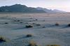
The Utah Wilderness Coalition Proposal
We recommend that Congress designate 27,200 acres in the northern portion of the Silver Island Mountains as wilderness. This excludes abandoned mines on the south end of the area. The easternmost part of the range, divided from the main part by a well used jeep trail, is included in our proposal. No intrusions whatsoever occur in the part of this unit which lie above an elevation of 5,200 feet.The BLM dropped the entire Silver Island range from further study during its intensive inventory, claiming that daily Air Force overflights significantly interrupt solitude and that vegetative and topographic screening is inadequate. The BLM's "screening" argument is specious; the area is unlikely to attract so many visitors that they could not easily find solitude. And as explained above, Congress specifically prohibited the agency from disqualifying wilderness on the basis of outside sights and sounds. Although airplane flights over wilderness areas need to be regulated, Congress designated several wilderness areas just east of Salt Lake City that receive a higher number of overflights.
The "overflights" argument hides an issue more directly concerned with land use: the military's proposed placement of electronic facilities throughout the West Desert. Ample lands outside of the UWC proposal are available for such facilities.
The BLM's inventory decision recognizes that existing vehicle ways do not detract significantly from wilderness values, but asserts that "ORV play has left its impression." Of the eight vehicle ways in the area, seven show no evidence of regular use and no evidence of construction or maintenance. All of these ways are two-wheel ruts with vegetation between them. Those in North Campbell and Lost canyons and those east of Jenkins Peak and west of Lambs Peak are largely revegetated. Their overall impression on the wildness of the area is negligible.
Mike Medberry
