THE WHITE CANYON WILDERNESS
- Classic High Desert
- Wilderness Recognized -- Except by the BLM
- Hundreds of Wells Authorized
- Wilderness Proposal Complements Park Lands
- CHEESEBOX CANYON AND HARMONY FLAT UNITS
- GRAVEL CANYON AND FORTKNOCKER CANYON UNITS
 Each year nearly 100,000 visitors explore Natural Bridges National Monument, searching for the solitude, beauty, and silence that are unique to the Colorado Plateau. Few of these visitors realize that the 7,800-acre monument is surrounded by 85,000 acres of BLM wild lands in the upper drainages of White Canyon. On most of its wild lands the BLM has made some gesture of recognition, however faint, for outstanding wilderness values. But when the BLM announced its draft wilderness proposal for Utah in February of 1986, not one acre of the White Canyon complex was recommended for wilderness designation.
Wilderness designation for the White Canyon area would protect outstanding backcountry canyoneering opportunities, thousands of acres of important habitat for desert bighorn sheep, and many ancient cultural resource sites, as well as complementing wild lands within Natural Bridges National Monument.
Classic High Desert
Between U.S. Highway 95 to the south, the rim of Dark Canyon to the north, the Elk Ridge road to the east, and Lake Powell to the west lie 85,000 acres of pristine wild lands administered by the BLM. Most of this broad plateau is covered with pinyon and juniper and studded with thousand-foot-high mesas and buttes. Deer, coyote, and desert bighorn sheep roam the rugged landscape. Raptors comb the air along the canyon rims.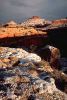 White Canyon has carved a maze of canyons into the Cedar Mesa Sandstone that underlies the plateau. These canyons are among the world's foremost displays of erosional sculpting, and the upper part of White Canyon was included within Natural Bridges National Monument in recognition of this character. The canyons on the BLM lands are more intimate and challenging, though no less deserving of recognition. They alternately narrow down into cool, dark, armspan-width slots -- and then widen again into coves littered with 40-ton houserocks and pocket forests of cottonwood, ponderosa, and fir.
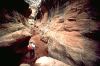
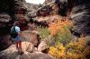
The canyon walls are honeycombed with alcoves, arches, windows, hanging gardens, and grottoes; the canyon floors are riddled with potholes. In places springwater forms deep pools, and occasional rainstorms bring torrents of floodwater raging through boulder gardens and thundering over pouroffs in spectacular waterfalls. Well over 100 miles of narrow, winding canyons in the White Canyon system form a network so labyrinthine that backpacking trips of two and three weeks can scarcely begin to touch its recreation potential.
As in much of the Cedar Mesa region, archeological values are high. Remnants of the ancient Anasazi culture, ranging from scattered stone-working sites to impressive cliff dwellings, are located throughout the proposed wilderness. The BLM notes in its wilderness DEIS that "no significant archeological work has been conducted" in Cheesebox Canyon, the area's sole WSA. However, the BLM goes on to say that if such inventories were made, they probably would disclose 600 sites in the WSA alone, up to 400 of which could be eligible for listing on the National Register of Historic Places.
 Isolation and rugged topography have protected the area from the vandalism that has scarred so many of southeastern Utah's irreplaceable archeological sites. That isolation may change, however, if the wildness of the area is not formally protected.
Wilderness Recognized -- Except by the BLM
The exceptional wilderness character of the White Canyon area has long been recognized. In the 1930s, the Interior Department identified the White Canyon region as part of a proposed 4.5-million-acre Escalante National Monument. More recently, the National Park Service identified the entire length of White Canyon, from Natural Bridges National Monument to Glen Canyon National Recreation Area, as a candidate for wild and scenic river designation. In 1979, Park Service officials proposed the acquisition of adjacent lands to protect the viewshed of Natural Bridges National Monument, and the National Parks and Conservation Association has since recommended the addition of 30,000 acres to the national monument.The BLM has recognized that most of the White Canyon wilderness provides critical lambing and rutting habitat for desert bighorn sheep. But the BLM does not share the concern of other agencies and citizens for the wilderness resource of White Canyon. In 1979, the BLM dropped four of five White Canyon roadless units from its wilderness inventory, claiming that they "clearly and obviously lack wilderness character." In 1986, the BLM insisted that Cheesebox Canyon was also unworthy of wilderness designation. Strange indeed, for the Cheesebox WSA is geologically, biologically, and topographically a natural extension of the wild lands within Natural Bridges National Monument.
The BLM claimed that the White Canyon area lacked wilderness character because of old mining scars around the perimeter of the canyon system. But extensive ground and aerial reconnaissance by Utah Wilderness Coalition volunteers in the spring of 1985 proved that most of these mining impacts are minimal or have been obliterated by erosion. The rest were easily excluded from the Coalition's wilderness proposals through minor boundary adjustments.
Hundreds of Wells Authorized
Why has the BLM overlooked the wilderness potential of White Canyon throughout a decade of wilderness inventory and study? In 1979, when the BLM removed the White Canyon roadless units from its wilderness inventory, the nation was in the throes of an energy crisis, and the agency was under intense pressure to permit mineral exploration inside the roadless area. Between 1979 and 1983, in the Cheesebox Canyon inventory unit alone, the BLM authorized the drilling of more than 200 new uranium exploration holes and the construction of 10 miles of new seismic lines. Fortunately, as a result of protests, appeals, and a decline in energy prices, few of the authorized actions were ever undertaken.Though the energy crisis has abated for the moment, new mining exploration proposals for the White Canyon wilderness may develop at any time. Meanwhile, so-called "range improvements" are the order of the day in the BLM's planning documents for the region. In 1985, the BLM proposed to build an 18-foot-wide, 8-mile-long stock driveway into the heart of the Gravel and Long Canyon roadless area. If constructed, the new road would invite vehicular traffic into the center of this wild area. Elsewhere inside the proposed White Canyon wilderness, the BLM proposes to chain down as much as 7,000 acres of pinyon-juniper forest (BLM, 1987b). Such developments will damage the region's extensive archeological resources, destroy critical habitat for desert bighorn sheep, and draw off-road vehicle traffic ever deeper into the roadless areas.
Although the White Canyon wilderness inventory was largely abandoned in order to promote energy exploration, the oil, gas, and uranium resources of this region are marginal at best. The BLM's San Juan Resource Management Plan rates the White Canyon region as low for oil, gas, uranium, and other hardrock minerals. According to the BLM, there are no coal, potash, geothermal, or other leasable minerals. "...all wells that have been drilled in this general area are now abandoned," the BLM said in its analysis of the Cheesebox Canyon WSA. "If oil and/or gas existed...in the WSA, there is a good chance that it has drained away..."
Wilderness Proposal Complements Park Lands
The Utah Wilderness Coalition proposes 85,000 acres of wilderness designations in White Canyon comprising four units. Since the White Canyon system is traversed by two low-grade dirt roads, the Coalition has used the road corridors as boundaries for three contiguous proposed wilderness areas west of Natural Bridges National Monument. A fourth proposed wilderness area abuts Natural Bridges on the southeast. Together these units would protect the recreational, cultural, and wildlife resources of the White Canyon area and would complement the purposes for which Natural Bridges National Monument was designated. Ray WheelerCHEESEBOX CANYON AND HARMONY FLAT UNITS
Highlights
These roadless lands surround additional wild country within Natural Bridges National Monument. A primitive road separates Cheesebox Canyon from the Gravel and Long Canyon unit to the west. Wilderness designation is needed to protect these lands for their primitive recreation opportunities, archeological sites, and wildlife habitat. Further vehicle access and mineral exploration would jeopardize these resources. We propose 28,500 acres of wilderness for Cheesebox Canyon and 9,100 acres for Harmony Flat.Geology and landforms
Tributaries of White Canyon have cut into the massive Cedar Mesa Sandstone throughout the forested benchlands surrounding Natural Bridges National Monument, forming Cheesebox, Hideout, and Deer canyons in the Cheesebox unit and Armstrong and Tuwa canyons in the Harmony Flat unit. The Cheesebox, a prominent butte visible from Highway 95, is a monument to the forces that stripped away hundreds of feet of overlying rocks, exposing the present plateau.Plant communities
An extensive pinyon-juniper forest covers the benchlands, while cottonwoods and other riparian plants grow along White Canyon, an ephemeral stream.Wildlife
Mule deer, mountain lion, bobcat, and a variety of smaller animals find habitat here. The western half of the Cheesebox unit is yearlong habitat for the desert bighorn sheep and also provides crucial rutting and lambing areas. Harmony Flat contains crucial deer winter range, according to the UDWR. The BLM notes that bald eagles use the area in the winter.Archeology and history
Thorough inventories have not been done, but 12 archeological sites, chiefly cliff dwellings and granaries, have been documented within the Cheesebox Canyon WSA (BLM, 1986). Many more sites of all types -- as many as 600 in the WSA alone, according to the BLM -- would probably be found if full surveys were undertaken. Harmony Flat has numerous sites of both Basketmaker and Pueblo age.Recreation
More than 35 miles of canyon-bottom travel is possible, ranging from easy walks and horse trips along the bottom of White Canyon to narrow, pouroff-ridden slots requiring rope work. Convenient access is available from Utah Highway 95, where short spur roads lead down into White Canyon. Deer, Armstrong, and Tuwa canyons are accessible from within the National Monument, the latter two forming a good loop hike by cutting across the mesa top between them.BLM recommendation
The BLM did not study nearly half the roadless lands in the Cheesebox unit, claiming that human impacts disqualified 12,000 acres in White, K and L, Hideout, and Deer canyons. The WSA boundary shrinks back from Natural Bridges National Monument, evidently in order to exclude three sections of state lands (see map). Instead of fragmenting the roadless area, the BLM should pursue an exchange of the state sections to consolidate BLM lands connecting Cheesebox and White canyons with the national monument. In 1986, the agency suggested that outside sights and sounds, chiefly traffic on nearby Highway 95 and visual intrusions from 20-year-old mining operations, compromise the solitude and naturalness found in the WSA. But Congress has repeatedly held this "sights and sounds" argument to be invalid, pointing out that wilderness areas that happen to be close to highways or towns hold value to the public because of their accessibility. The agency found nearly all of the Harmony Flat unit to be natural but could find no outstanding solitude or primitive recreation possibilities, despite the extensive pinyon-juniper forest and incised canyons. It stated in a 1981 letter that the unit's proximity to the national monument is "totally irrelevant," despite a Park Service statement in 1979 that "We concur in the BLM's designation of [the initial inventory unit] for further wilderness study and would consider lands within the Monument contiguous to this area as possible wilderness."Coalition proposal
We have included several thousand acres in the Cheesebox unit that the BLM excluded from study; the intrusions are minimal, consisting mainly of old, eroding mineral-prospecting roads and cattle driveways. Imprints in Harmony Flat consist of six miles of cleared fenceline running along Highway 95, an old, closed-off access road from the highway to Owachomo Natural Bridge (now shown as a "foot trail" on the USGS map), and a road leading to forest chainings in a state section on the east. The Department of Energy's analysis of uranium potential indicates small, low-grade deposits only; most of the uranium-bearing rocks have already been prospected. Potential for other minerals and oil and gas in the unit is low, according to the BLM. Both units should be designated as wilderness together with roadless lands within the national monument to allow coordinated management of these outstanding wild lands regardless of jurisdictional lines.GRAVEL CANYON AND FORTKNOCKER CANYON UNITS
Highlights
The northern half of the White Canyon complex has crucial bighorn sheep habitat, important archeologic resources, and some of the most challenging canyoneering in the state -- all located just off Highway 95. Neither unit was designated a WSA by the BLM. We propose 35,000 acres of wilderness in Gravel and Long Canyon and 12,400 acres in Fortknocker Canyon.
Geology and landforms
Gravel Canyon and its neighbor to the north, Long Canyon, wind through wide benchlands surrounded by thousand-foot-high red mesas and buttes. Both canyons feed into White Canyon, as does Fortknocker Canyon farther downstream. In all, over 60 miles of narrow canyons wind through these units, a superb example of erosional sculpting of the Cedar Mesa Sandstone. The benchlands and mesas between the canyons form the spectacular vistas from the Highway 95 scenic corridor. The BLM designated an Area of Critical Environmental Concern for scenic values here.Plant communities
The rocky benches in these units are covered with pinyon and juniper trees, with blackbrush, yucca, beavertail cactus, and associated desert shrubs also present. Soils are relatively undisturbed and thick cryptogam is common. Portions of these units have unusually healthy plant communities. Hanging gardens are found at seeps in some of the sidecanyons.Wildlife
Desert bighorn sheep use most of these units yearlong; they also find critical rutting and lambing habitat here. Riparian habitat exists in the intermittently flowing White Canyon.Archeology and history
Like much of the Cedar Mesa region, these units have important remains of the Anasazi culture that depend on isolation and remoteness as protection from vandalism.